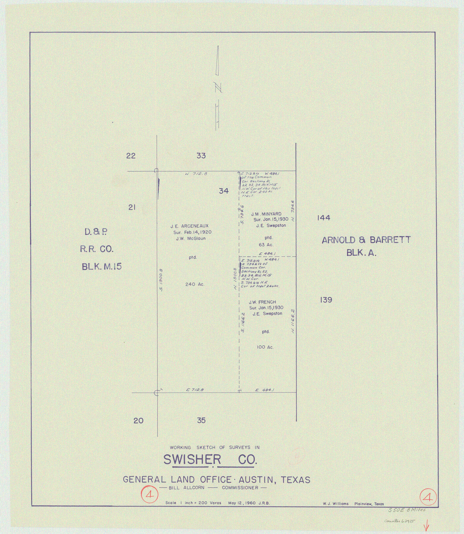
Swisher County Working Sketch 4
-
Map/Doc
62415
-
Collection
General Map Collection
-
Object Dates
5/12/1960 (Creation Date)
-
Counties
Swisher
-
Subjects
Surveying Working Sketch
-
Height x Width
23.0 x 19.9 inches
58.4 x 50.6 cm
-
Scale
1" = 200 varas
Part of: General Map Collection
Washington County Working Sketch 4

Print $20.00
- Digital $50.00
Washington County Working Sketch 4
1992
Size 28.2 x 25.2 inches
Map/Doc 72365
Harris County Rolled Sketch 80

Print $20.00
- Digital $50.00
Harris County Rolled Sketch 80
1958
Size 31.1 x 31.0 inches
Map/Doc 6116
Trinity River, McKinney Sheet/East Fork of Trinity River

Print $20.00
- Digital $50.00
Trinity River, McKinney Sheet/East Fork of Trinity River
1931
Size 40.6 x 28.0 inches
Map/Doc 65241
Jim Wells County Working Sketch 11

Print $20.00
- Digital $50.00
Jim Wells County Working Sketch 11
1953
Size 20.4 x 22.6 inches
Map/Doc 66609
Harbor Pass and Bar at Brazos Santiago, Texas

Print $20.00
- Digital $50.00
Harbor Pass and Bar at Brazos Santiago, Texas
1871
Size 18.2 x 26.8 inches
Map/Doc 72983
McMullen County Sketch File 38

Print $20.00
- Digital $50.00
McMullen County Sketch File 38
1938
Size 31.3 x 17.5 inches
Map/Doc 12064
Sutton County Working Sketch 16

Print $40.00
- Digital $50.00
Sutton County Working Sketch 16
1972
Size 30.9 x 67.6 inches
Map/Doc 62359
Freestone County Working Sketch 16

Print $20.00
- Digital $50.00
Freestone County Working Sketch 16
1980
Size 47.1 x 39.7 inches
Map/Doc 69258
Crosby County Rolled Sketch 1

Print $20.00
- Digital $50.00
Crosby County Rolled Sketch 1
1950
Size 25.3 x 21.1 inches
Map/Doc 5640
Lampasas County Boundary File 16

Print $14.00
- Digital $50.00
Lampasas County Boundary File 16
Size 8.9 x 8.2 inches
Map/Doc 56216
El Paso County Working Sketch 37

Print $20.00
- Digital $50.00
El Paso County Working Sketch 37
1983
Size 28.2 x 24.8 inches
Map/Doc 69059
Cottle County Working Sketch 14a

Print $20.00
- Digital $50.00
Cottle County Working Sketch 14a
1963
Size 31.2 x 42.1 inches
Map/Doc 68324
You may also like
Working Sketch in Baylor and Throckmorton Cos.

Print $20.00
- Digital $50.00
Working Sketch in Baylor and Throckmorton Cos.
1890
Size 24.2 x 20.8 inches
Map/Doc 75771
Gray County Sketch File 14

Print $4.00
- Digital $50.00
Gray County Sketch File 14
1946
Size 11.3 x 8.9 inches
Map/Doc 24457
Map of the International and Great Northern Railroad between Austin and San Antonio, Texas

Print $40.00
- Digital $50.00
Map of the International and Great Northern Railroad between Austin and San Antonio, Texas
1881
Size 42.5 x 121.5 inches
Map/Doc 64776
Callahan County Working Sketch 5

Print $20.00
- Digital $50.00
Callahan County Working Sketch 5
1954
Size 24.3 x 33.8 inches
Map/Doc 67887
McMullen County Working Sketch 31

Print $20.00
- Digital $50.00
McMullen County Working Sketch 31
1957
Size 39.9 x 25.9 inches
Map/Doc 70732
Lee County Sketch File 1

Print $4.00
- Digital $50.00
Lee County Sketch File 1
1856
Size 13.1 x 8.2 inches
Map/Doc 29678
Flight Mission No. BRA-8M, Frame 125, Jefferson County

Print $20.00
- Digital $50.00
Flight Mission No. BRA-8M, Frame 125, Jefferson County
1953
Size 15.9 x 15.7 inches
Map/Doc 85621
General Highway Map, Fort Bend County, Texas

Print $20.00
General Highway Map, Fort Bend County, Texas
1961
Size 18.1 x 24.5 inches
Map/Doc 79469
Hudspeth County Sketch File 40

Print $8.00
- Digital $50.00
Hudspeth County Sketch File 40
1944
Size 11.2 x 8.6 inches
Map/Doc 27012
Cherokee County Sketch File 22b

Print $20.00
- Digital $50.00
Cherokee County Sketch File 22b
1906
Size 15.5 x 14.0 inches
Map/Doc 82019
General Highway Map, Brewster County, Texas

Print $20.00
General Highway Map, Brewster County, Texas
1940
Size 18.5 x 25.1 inches
Map/Doc 79028
Atascosa County Working Sketch 35

Print $20.00
- Digital $50.00
Atascosa County Working Sketch 35
1992
Size 34.6 x 48.1 inches
Map/Doc 67231