McMullen County Sketch File 38
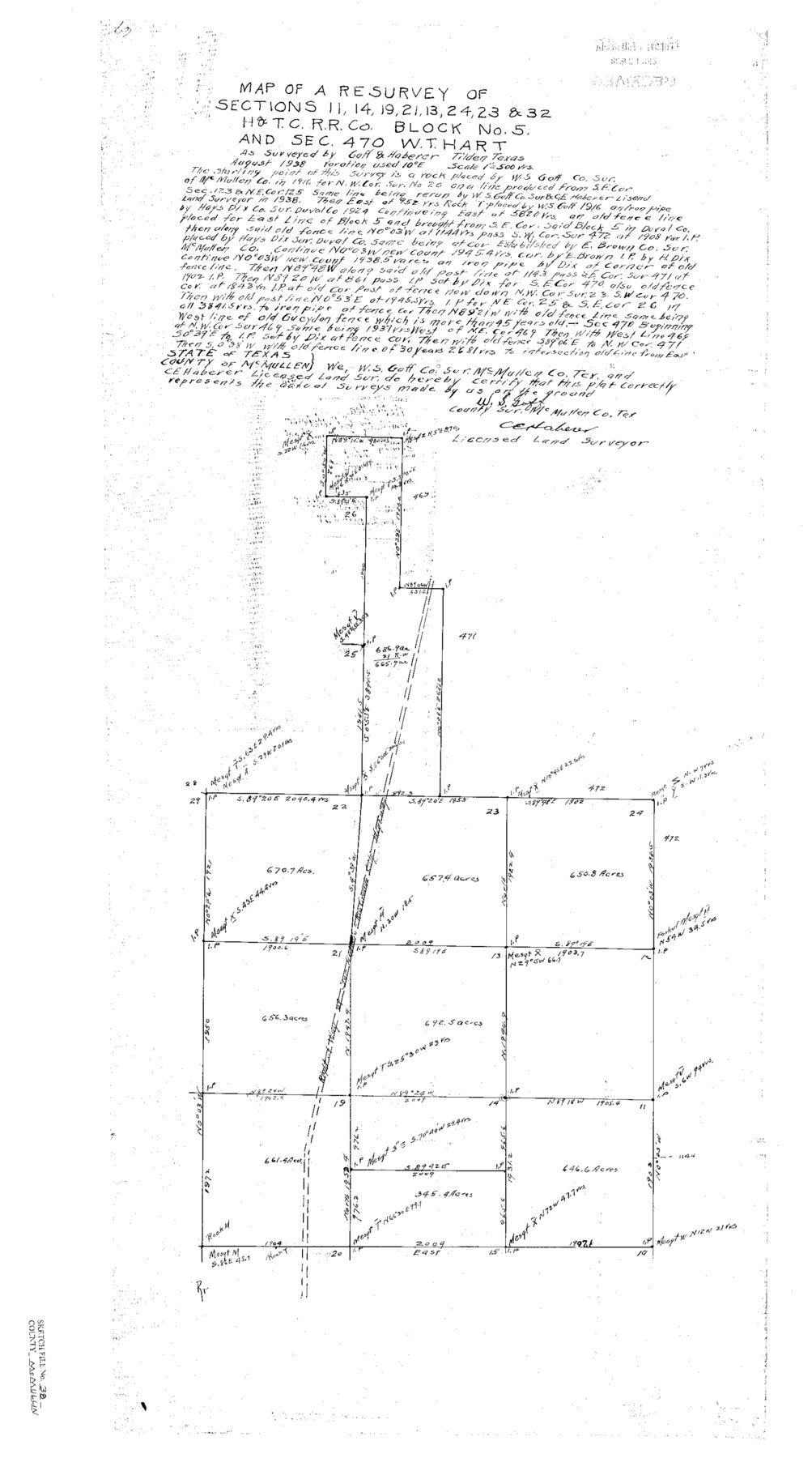
Map of a Resurvey of Sections 11, 14, 19, 21, 13, 24, 23 & 32, H&TCRRCo. Block No. 5 & Sec. 470 W. T. Hart, McMullen County, Texas
-
Map/Doc
12064
-
Collection
General Map Collection
-
Object Dates
1938 (Creation Date)
1938/9/27 (File Date)
1938 (Survey Date)
-
People and Organizations
C.E. Haberer (Surveyor/Engineer)
W.S. Goff (Surveyor/Engineer)
-
Counties
McMullen
-
Subjects
Surveying Sketch File
-
Height x Width
31.3 x 17.5 inches
79.5 x 44.5 cm
-
Medium
paper, print
-
Scale
1:500
Part of: General Map Collection
Liberty County Working Sketch 75

Print $20.00
- Digital $50.00
Liberty County Working Sketch 75
1980
Size 23.2 x 23.8 inches
Map/Doc 70535
Brewster County Rolled Sketch 92

Print $20.00
- Digital $50.00
Brewster County Rolled Sketch 92
1950
Size 24.3 x 15.2 inches
Map/Doc 5250
Reconnoissances of Routes from San Antonio de Bexar, El Paso del Norte &c &c

Print $20.00
- Digital $50.00
Reconnoissances of Routes from San Antonio de Bexar, El Paso del Norte &c &c
1849
Size 26.3 x 38.9 inches
Map/Doc 94853
Zapata County

Print $40.00
- Digital $50.00
Zapata County
1935
Size 56.7 x 43.2 inches
Map/Doc 63145
Flight Mission No. BRE-2P, Frame 16, Nueces County

Print $20.00
- Digital $50.00
Flight Mission No. BRE-2P, Frame 16, Nueces County
1956
Size 18.3 x 22.2 inches
Map/Doc 86725
McLennan County Boundary File 1

Print $80.00
- Digital $50.00
McLennan County Boundary File 1
Size 19.4 x 12.3 inches
Map/Doc 56937
Crockett County Rolled Sketch 37

Print $20.00
- Digital $50.00
Crockett County Rolled Sketch 37
Size 36.7 x 29.3 inches
Map/Doc 5589
Callahan County Sketch File 10

Print $40.00
- Digital $50.00
Callahan County Sketch File 10
Size 21.7 x 24.7 inches
Map/Doc 11039
Flight Mission No. CUG-1P, Frame 71, Kleberg County

Print $20.00
- Digital $50.00
Flight Mission No. CUG-1P, Frame 71, Kleberg County
1956
Size 18.5 x 22.2 inches
Map/Doc 86136
San Patricio County Rolled Sketch 21

Print $20.00
- Digital $50.00
San Patricio County Rolled Sketch 21
1935
Size 25.9 x 24.7 inches
Map/Doc 7580
Loving County Working Sketch 6

Print $40.00
- Digital $50.00
Loving County Working Sketch 6
1947
Size 31.3 x 51.0 inches
Map/Doc 70638
Parker County Working Sketch 6

Print $20.00
- Digital $50.00
Parker County Working Sketch 6
1923
Map/Doc 71456
You may also like
McMullen County Rolled Sketch 23

Print $20.00
- Digital $50.00
McMullen County Rolled Sketch 23
2020
Size 24.5 x 36.3 inches
Map/Doc 95949
Chart of the Rio Bravo del Norte traced from a survey made by Henry Austin by Lieut. Bowman, 3d. Infy.

Print $20.00
- Digital $50.00
Chart of the Rio Bravo del Norte traced from a survey made by Henry Austin by Lieut. Bowman, 3d. Infy.
1866
Size 18.3 x 27.8 inches
Map/Doc 72889
Scurry County Sketch Mineral Application No. 42631

Print $20.00
- Digital $50.00
Scurry County Sketch Mineral Application No. 42631
1950
Size 16.7 x 23.9 inches
Map/Doc 92966
Lynn County Boundary File 6a

Print $2.00
- Digital $50.00
Lynn County Boundary File 6a
Size 11.2 x 8.7 inches
Map/Doc 56641
Morris County Rolled Sketch 2A

Print $20.00
- Digital $50.00
Morris County Rolled Sketch 2A
Size 24.4 x 19.2 inches
Map/Doc 10271
Brazoria County Rolled Sketch AM

Print $20.00
- Digital $50.00
Brazoria County Rolled Sketch AM
1935
Size 27.1 x 43.2 inches
Map/Doc 5189
La Salle County Rolled Sketch 20

Print $20.00
- Digital $50.00
La Salle County Rolled Sketch 20
1954
Size 24.6 x 40.1 inches
Map/Doc 6584
Lynn County Sketch File 9

Print $4.00
- Digital $50.00
Lynn County Sketch File 9
1904
Size 11.2 x 8.7 inches
Map/Doc 30475
Pecos County Sketch File 18

Print $32.00
- Digital $50.00
Pecos County Sketch File 18
1884
Size 24.5 x 9.6 inches
Map/Doc 12159
Kent County Boundary File 11

Print $4.00
- Digital $50.00
Kent County Boundary File 11
Size 13.9 x 8.8 inches
Map/Doc 55895
Panola County Sketch File 30

Print $4.00
- Digital $50.00
Panola County Sketch File 30
1944
Size 2.8 x 8.9 inches
Map/Doc 33505
Map of Texas Gulf Coast and Continental Shelf showing Natural Gas Pipe Lines

Print $40.00
- Digital $50.00
Map of Texas Gulf Coast and Continental Shelf showing Natural Gas Pipe Lines
1983
Size 40.9 x 59.1 inches
Map/Doc 75969