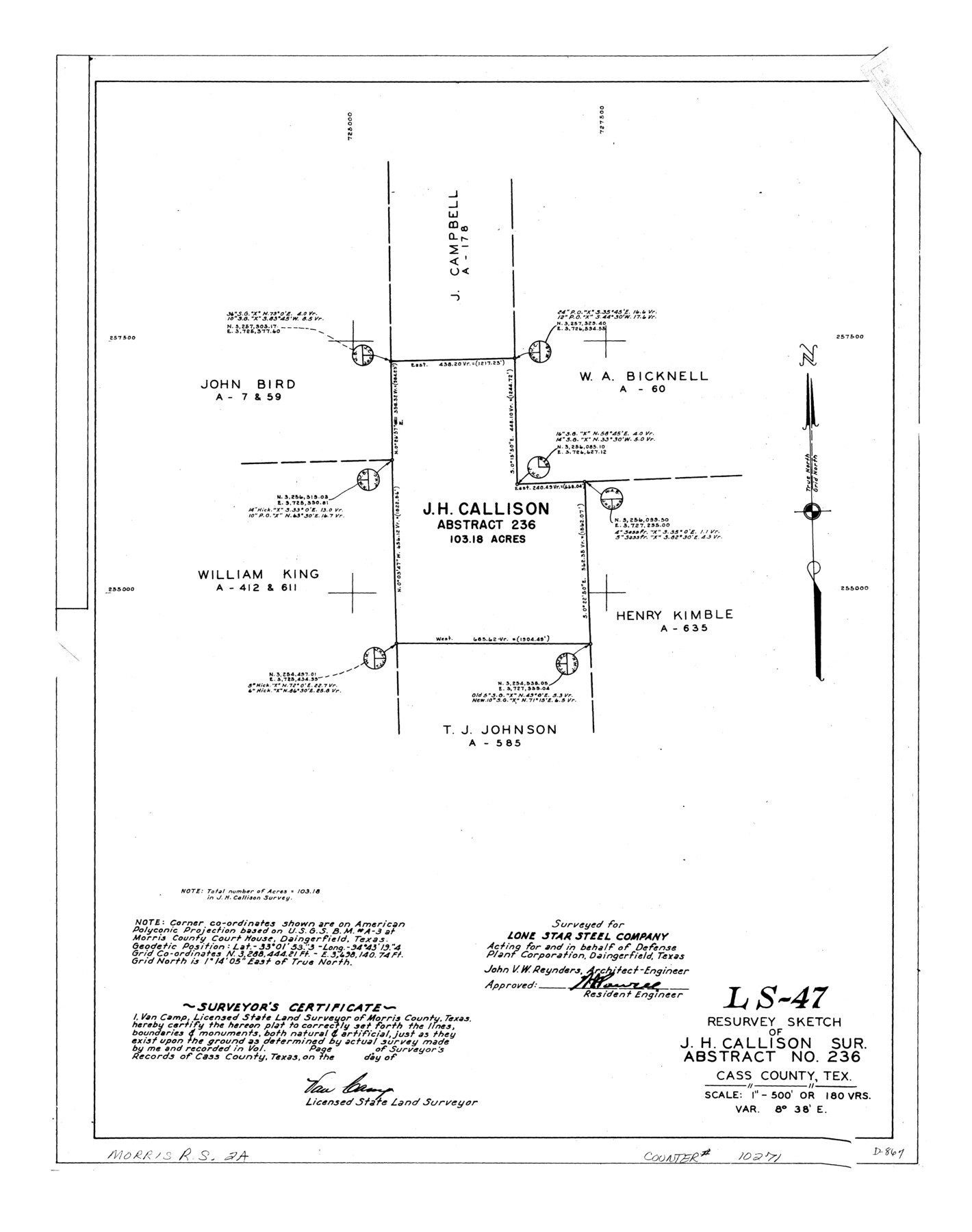
Morris County Rolled Sketch 2A
LS-47 - Resurvey sketch of J.H. Callison sur., abstract no. 236, Cass County, Tex.
-
Map/Doc
10271
-
Collection
General Map Collection
-
People and Organizations
Van Camp (Surveyor/Engineer)
-
Counties
Cass
-
Subjects
Surveying Rolled Sketch
-
Height x Width
24.4 x 19.2 inches
62.0 x 48.8 cm
-
Medium
linen, manuscript
-
Scale
1" = 180 varas
-
Comments
See Morris County Rolled Sketch 2 (9550) for map of all retracement surveys made for Lone Star Steel Company.
Related maps
Morris County Rolled Sketch 2

Print $40.00
- Digital $50.00
Morris County Rolled Sketch 2
1944
Size 59.4 x 43.5 inches
Map/Doc 9550
Part of: General Map Collection
Flight Mission No. CRC-3R, Frame 29, Chambers County

Print $20.00
- Digital $50.00
Flight Mission No. CRC-3R, Frame 29, Chambers County
1956
Size 18.6 x 22.3 inches
Map/Doc 84804
East Half - Brown County

Print $40.00
- Digital $50.00
East Half - Brown County
1982
Size 141.3 x 36.8 inches
Map/Doc 97385
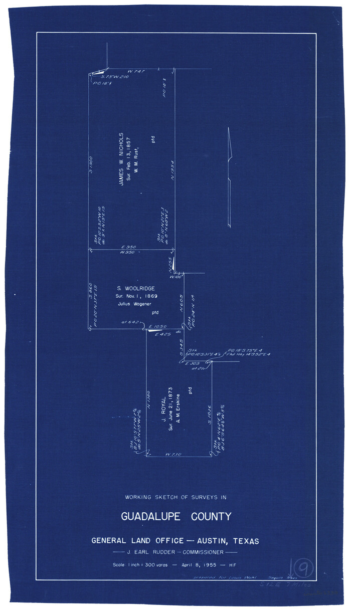
Guadalupe County Working Sketch 9
Print $20.00
- Digital $50.00
Guadalupe County Working Sketch 9
1955
Size 21.9 x 12.6 inches
Map/Doc 63318
Castro County Sketch File 10

Print $6.00
- Digital $50.00
Castro County Sketch File 10
1916
Size 8.2 x 5.4 inches
Map/Doc 17501
Briscoe County Rolled Sketch 17

Print $20.00
- Digital $50.00
Briscoe County Rolled Sketch 17
1946
Size 36.7 x 28.7 inches
Map/Doc 5331
Madison County Working Sketch 15

Print $20.00
- Digital $50.00
Madison County Working Sketch 15
2009
Size 42.3 x 36.0 inches
Map/Doc 89019
Flight Mission No. DAG-26K, Frame 56, Matagorda County

Print $20.00
- Digital $50.00
Flight Mission No. DAG-26K, Frame 56, Matagorda County
1953
Size 18.6 x 22.7 inches
Map/Doc 86576
Grayson County Working Sketch 10

Print $20.00
- Digital $50.00
Grayson County Working Sketch 10
1951
Size 41.6 x 37.8 inches
Map/Doc 63249
Crane County Sketch File 3

Print $20.00
- Digital $50.00
Crane County Sketch File 3
Size 23.6 x 26.0 inches
Map/Doc 11204

[Beaumont, Sour Lake and Western Ry. Right of Way and Alignment - Frisco]
![64128, [Beaumont, Sour Lake and Western Ry. Right of Way and Alignment - Frisco], General Map Collection](https://historictexasmaps.com/wmedia_w700/maps/64128.tif.jpg)
Print $20.00
- Digital $50.00
[Beaumont, Sour Lake and Western Ry. Right of Way and Alignment - Frisco]
1910
Size 20.1 x 45.9 inches
Map/Doc 64128
[Map of Polk County]
![4614, [Map of Polk County], General Map Collection](https://historictexasmaps.com/wmedia_w700/maps/4614-1.tif.jpg)
Print $20.00
- Digital $50.00
[Map of Polk County]
Size 21.7 x 25.8 inches
Map/Doc 4614
You may also like
The Dividing Link - Mexico & Central America

The Dividing Link - Mexico & Central America
Size 20.5 x 31.2 inches
Map/Doc 95941
Milam County Rolled Sketch 3A

Print $40.00
- Digital $50.00
Milam County Rolled Sketch 3A
1967
Size 49.1 x 38.8 inches
Map/Doc 43048
[Surveys in Chambers County, along East Bay Bayou and Elm Bayou]
![69752, [Surveys in Chambers County, along East Bay Bayou and Elm Bayou], General Map Collection](https://historictexasmaps.com/wmedia_w700/maps/69752.tif.jpg)
Print $2.00
- Digital $50.00
[Surveys in Chambers County, along East Bay Bayou and Elm Bayou]
1847
Size 7.5 x 9.3 inches
Map/Doc 69752
Flight Mission No. DCL-6C, Frame 2, Kenedy County

Print $20.00
- Digital $50.00
Flight Mission No. DCL-6C, Frame 2, Kenedy County
1943
Size 18.6 x 22.4 inches
Map/Doc 85862
Nueces County Rolled Sketch 39

Print $20.00
- Digital $50.00
Nueces County Rolled Sketch 39
1957
Size 32.9 x 45.3 inches
Map/Doc 6879
[Sketch for Mineral Application 1487 -Big Wichita River, Ernest R. Smith]
![65685, [Sketch for Mineral Application 1487 -Big Wichita River, Ernest R. Smith], General Map Collection](https://historictexasmaps.com/wmedia_w700/maps/65685.tif.jpg)
Print $40.00
- Digital $50.00
[Sketch for Mineral Application 1487 -Big Wichita River, Ernest R. Smith]
1918
Size 129.3 x 31.5 inches
Map/Doc 65685
Flight Mission No. CUG-1P, Frame 79, Kleberg County

Print $20.00
- Digital $50.00
Flight Mission No. CUG-1P, Frame 79, Kleberg County
1956
Size 18.7 x 22.2 inches
Map/Doc 86144
Liberty County Sketch File 2

Print $2.00
- Digital $50.00
Liberty County Sketch File 2
Size 7.7 x 3.3 inches
Map/Doc 29883
Coleman County Sketch File 15

Print $4.00
- Digital $50.00
Coleman County Sketch File 15
1848
Size 7.3 x 13.0 inches
Map/Doc 18681
Pecos County Working Sketch 71

Print $20.00
- Digital $50.00
Pecos County Working Sketch 71
1957
Size 41.6 x 26.0 inches
Map/Doc 71543
Wilbarger County Working Sketch 3

Print $20.00
- Digital $50.00
Wilbarger County Working Sketch 3
1923
Size 22.0 x 23.9 inches
Map/Doc 72541
Aransas County Sketch File 13

Print $4.00
- Digital $50.00
Aransas County Sketch File 13
Size 7.0 x 8.4 inches
Map/Doc 13126