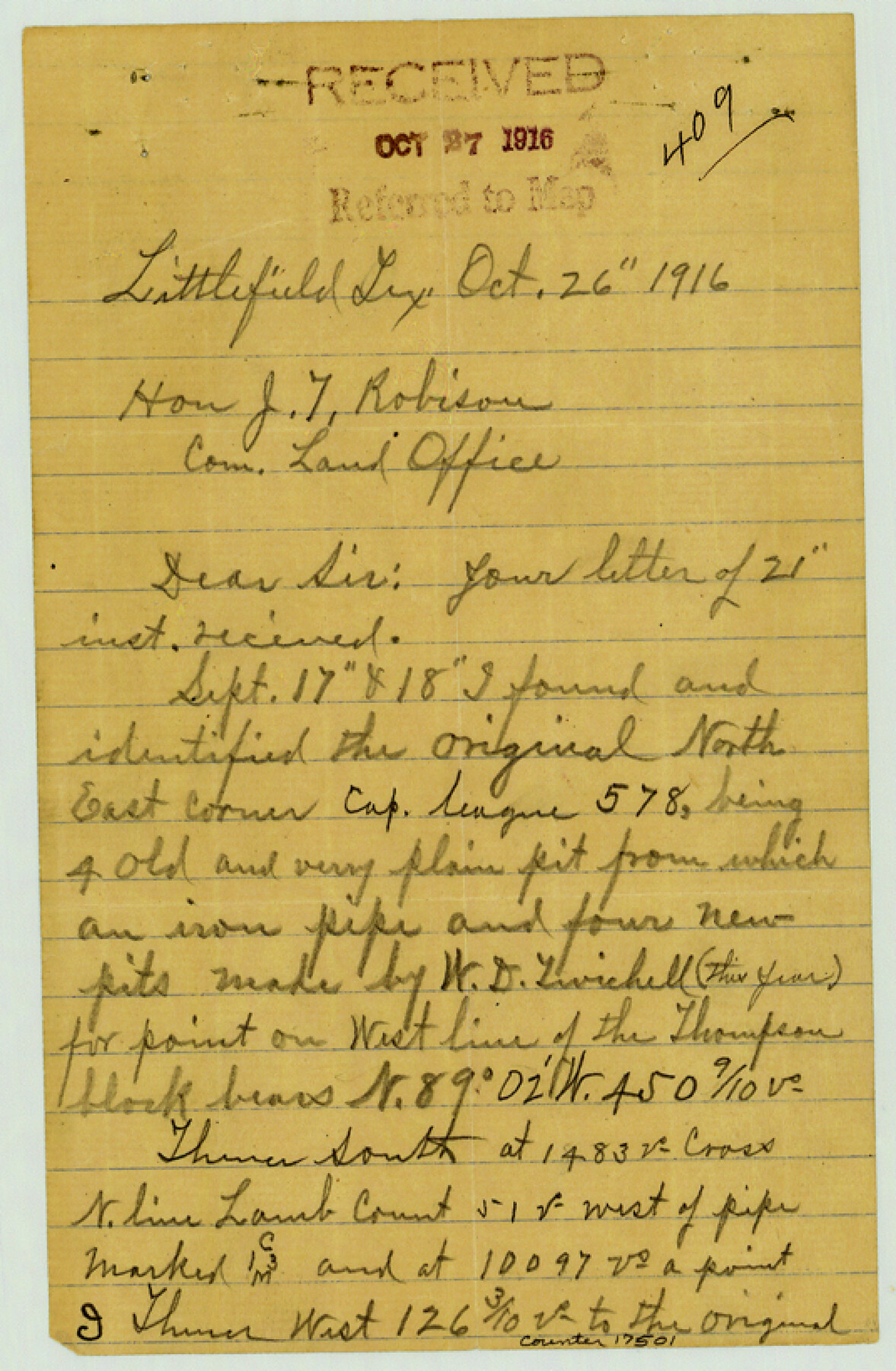
Castro County Sketch File 10
[Letter referring to connections between League 578 to League 616]
-
Map/Doc
17501
-
Collection
General Map Collection
-
Object Dates
1916/10/26 (Creation Date)
1916/10/27 (File Date)
-
People and Organizations
R.S. Hunnicutt (Surveyor/Engineer)
-
Counties
Castro Lamb
-
Subjects
Surveying Sketch File
-
Height x Width
8.2 x 5.4 inches
20.8 x 13.7 cm
-
Medium
paper, manuscript
Part of: General Map Collection
Mason County Sketch File 13

Print $4.00
- Digital $50.00
Mason County Sketch File 13
Size 7.3 x 6.2 inches
Map/Doc 30701
Jefferson County Sketch File 15b

Print $26.00
- Digital $50.00
Jefferson County Sketch File 15b
Size 17.4 x 33.2 inches
Map/Doc 11869
Knox County Working Sketch 5

Print $20.00
- Digital $50.00
Knox County Working Sketch 5
1919
Size 27.1 x 23.2 inches
Map/Doc 70247
Brewster County Rolled Sketch 27

Print $40.00
- Digital $50.00
Brewster County Rolled Sketch 27
Size 35.1 x 48.8 inches
Map/Doc 8474
Flight Mission No. BRE-2P, Frame 50, Nueces County

Print $20.00
- Digital $50.00
Flight Mission No. BRE-2P, Frame 50, Nueces County
1956
Size 18.5 x 22.4 inches
Map/Doc 86752
Map of the Navosoto [sp.] River, Washington County
![64, Map of the Navosoto [sp.] River, Washington County, General Map Collection](https://historictexasmaps.com/wmedia_w700/maps/64.tif.jpg)
Print $20.00
- Digital $50.00
Map of the Navosoto [sp.] River, Washington County
1842
Size 15.7 x 14.2 inches
Map/Doc 64
Val Verde County Working Sketch 28

Print $20.00
- Digital $50.00
Val Verde County Working Sketch 28
1937
Size 45.9 x 38.6 inches
Map/Doc 72163
Colorado County Boundary File 1

Print $8.00
- Digital $50.00
Colorado County Boundary File 1
Size 14.0 x 8.6 inches
Map/Doc 51768
Young County Working Sketch 12

Print $20.00
- Digital $50.00
Young County Working Sketch 12
1921
Size 17.6 x 19.0 inches
Map/Doc 62035
Presidio County

Print $40.00
- Digital $50.00
Presidio County
1875
Size 98.1 x 36.4 inches
Map/Doc 88866
Robertson County Working Sketch 13

Print $20.00
- Digital $50.00
Robertson County Working Sketch 13
1987
Size 28.0 x 29.4 inches
Map/Doc 63586
Bell County Working Sketch 11

Print $20.00
- Digital $50.00
Bell County Working Sketch 11
1956
Size 31.8 x 24.4 inches
Map/Doc 67351
You may also like
San Jacinto County Boundary File 2

Print $5.00
- Digital $50.00
San Jacinto County Boundary File 2
Size 15.8 x 11.0 inches
Map/Doc 58561
Knox County Rolled Sketch 18

Print $20.00
- Digital $50.00
Knox County Rolled Sketch 18
1945
Size 23.1 x 29.5 inches
Map/Doc 6558

San Augustine County Working Sketch 15

Print $20.00
- Digital $50.00
San Augustine County Working Sketch 15
1959
Size 26.6 x 36.7 inches
Map/Doc 63703
The Republic County of Matagorda. December 24, 1844

Print $20.00
The Republic County of Matagorda. December 24, 1844
2020
Size 21.0 x 21.7 inches
Map/Doc 96223
Coke County Working Sketch 30

Print $20.00
- Digital $50.00
Coke County Working Sketch 30
1982
Size 15.7 x 22.4 inches
Map/Doc 76064
Flight Mission No. DCL-7C, Frame 41, Kenedy County

Print $20.00
- Digital $50.00
Flight Mission No. DCL-7C, Frame 41, Kenedy County
1943
Size 15.4 x 15.2 inches
Map/Doc 86029
Donley County Sketch File 25

Print $20.00
- Digital $50.00
Donley County Sketch File 25
Size 32.5 x 26.2 inches
Map/Doc 11369
Flight Mission No. CRC-4R, Frame 74, Chambers County

Print $20.00
- Digital $50.00
Flight Mission No. CRC-4R, Frame 74, Chambers County
1956
Size 18.7 x 22.5 inches
Map/Doc 84878
Val Verde County Sketch File 35A

Print $18.00
- Digital $50.00
Val Verde County Sketch File 35A
1936
Size 4.4 x 7.4 inches
Map/Doc 39253
Baylor County Sketch File 12g

Print $50.00
- Digital $50.00
Baylor County Sketch File 12g
Size 11.4 x 8.9 inches
Map/Doc 14170
Map of Falls County

Print $20.00
- Digital $50.00
Map of Falls County
1855
Size 21.4 x 23.9 inches
Map/Doc 3532