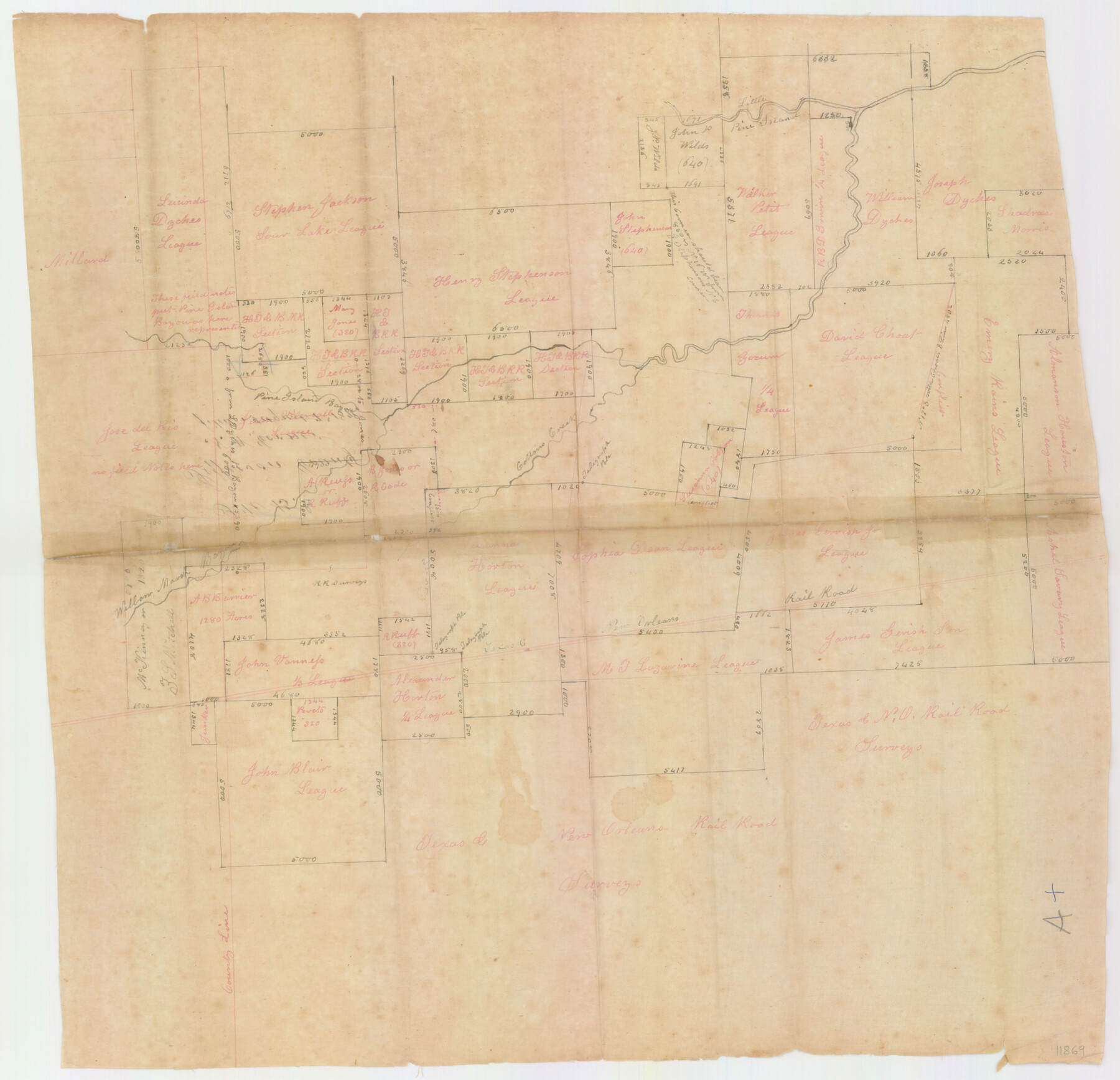
Jefferson County Sketch File 15b
N. W. Corner
-
Map/Doc
11869
-
Collection
General Map Collection
-
Object Dates
8/7/1871 (File Date)
7/13/1874 (Correspondence Date)
-
People and Organizations
George Armstrong (Surveyor/Engineer)
-
Counties
Jefferson Hardin Liberty
-
Subjects
Surveying Sketch File
-
Height x Width
17.4 x 33.2 inches
44.2 x 84.3 cm
-
Medium
paper, manuscript
-
Features
Little Pine Island Bayou
Pine Island Bayou
T&NO
Cottons Creek
Willow Marsh Bayou
Pine Island Bayou South Fork
Part of: General Map Collection

Ector County Sketch File 5

Print $6.00
- Digital $50.00
Ector County Sketch File 5
1939
Size 9.1 x 14.5 inches
Map/Doc 21637
Childress County

Print $20.00
- Digital $50.00
Childress County
1921
Size 44.1 x 32.2 inches
Map/Doc 4746
Starr County Sketch File 9

Print $22.00
- Digital $50.00
Starr County Sketch File 9
Size 9.1 x 7.9 inches
Map/Doc 36861
Wharton County Working Sketch 19

Print $20.00
- Digital $50.00
Wharton County Working Sketch 19
1940
Size 21.4 x 23.0 inches
Map/Doc 72483
Montague County Working Sketch 16

Print $20.00
- Digital $50.00
Montague County Working Sketch 16
1946
Size 44.1 x 40.8 inches
Map/Doc 71082
Austin County Boundary File 2

Print $32.00
- Digital $50.00
Austin County Boundary File 2
Size 22.4 x 30.7 inches
Map/Doc 50236
Maps of Gulf Intracoastal Waterway, Texas - Sabine River to the Rio Grande and connecting waterways including ship channels

Print $20.00
- Digital $50.00
Maps of Gulf Intracoastal Waterway, Texas - Sabine River to the Rio Grande and connecting waterways including ship channels
1966
Size 14.6 x 22.2 inches
Map/Doc 61946
Flight Mission No. DQN-5K, Frame 40, Calhoun County

Print $20.00
- Digital $50.00
Flight Mission No. DQN-5K, Frame 40, Calhoun County
1953
Size 18.6 x 22.1 inches
Map/Doc 84388
Callahan County Working Sketch 8

Print $20.00
- Digital $50.00
Callahan County Working Sketch 8
Size 30.5 x 23.7 inches
Map/Doc 67890
Cooke County Working Sketch 26

Print $20.00
- Digital $50.00
Cooke County Working Sketch 26
1974
Size 33.9 x 39.2 inches
Map/Doc 68263
Smith County Sketch File 17

Print $8.00
- Digital $50.00
Smith County Sketch File 17
1853
Size 12.6 x 8.1 inches
Map/Doc 36789
You may also like
Flight Mission No. DQO-8K, Frame 40, Galveston County

Print $20.00
- Digital $50.00
Flight Mission No. DQO-8K, Frame 40, Galveston County
1952
Size 18.5 x 22.3 inches
Map/Doc 85147
San Patricio County Working Sketch 8

Print $20.00
- Digital $50.00
San Patricio County Working Sketch 8
1936
Size 26.9 x 21.5 inches
Map/Doc 63770

Galveston County NRC Article 33.136 Sketch 61

Print $140.00
- Digital $50.00
Galveston County NRC Article 33.136 Sketch 61
2009
Size 24.0 x 36.0 inches
Map/Doc 94824
Sutton County

Print $40.00
- Digital $50.00
Sutton County
1941
Size 42.3 x 56.8 inches
Map/Doc 63052
Flight Mission No. DQO-2K, Frame 101, Galveston County

Print $20.00
- Digital $50.00
Flight Mission No. DQO-2K, Frame 101, Galveston County
1952
Size 18.8 x 22.5 inches
Map/Doc 85028
Map of surveys 191 & 192 T. C. R.R. Co. in Travis County, Texas

Print $20.00
- Digital $50.00
Map of surveys 191 & 192 T. C. R.R. Co. in Travis County, Texas
1915
Size 20.6 x 13.5 inches
Map/Doc 75556
Erath County Working Sketch 28

Print $20.00
- Digital $50.00
Erath County Working Sketch 28
1970
Size 31.8 x 31.6 inches
Map/Doc 69109
Intracoastal Waterway in Texas - Corpus Christi to Point Isabel including Arroyo Colorado to Mo. Pac. R.R. Bridge Near Harlingen

Print $20.00
- Digital $50.00
Intracoastal Waterway in Texas - Corpus Christi to Point Isabel including Arroyo Colorado to Mo. Pac. R.R. Bridge Near Harlingen
1933
Size 27.7 x 40.7 inches
Map/Doc 61858
Duval County Working Sketch 33

Print $20.00
- Digital $50.00
Duval County Working Sketch 33
1951
Size 21.9 x 23.3 inches
Map/Doc 68757
Crockett County Working Sketch 57

Print $20.00
- Digital $50.00
Crockett County Working Sketch 57
1954
Size 35.9 x 38.8 inches
Map/Doc 68390
Edwards County Working Sketch 124

Print $20.00
- Digital $50.00
Edwards County Working Sketch 124
1976
Size 20.0 x 27.8 inches
Map/Doc 69000