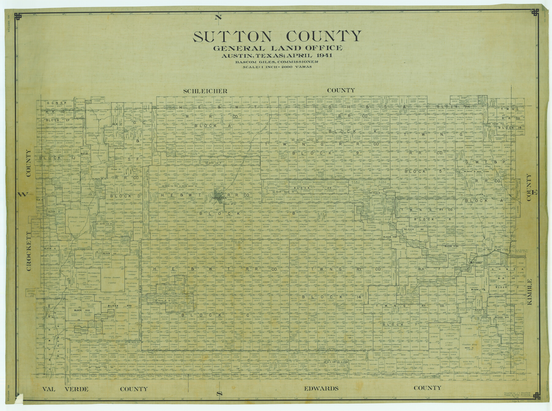
Sutton County
-
Map/Doc
63052
-
Collection
General Map Collection
-
Object Dates
1941 (Creation Date)
-
People and Organizations
Texas General Land Office (Publisher)
Bascom Giles (GLO Commissioner)
J.L. Woodland (Compiler)
-
Counties
Sutton
-
Subjects
County
-
Height x Width
42.3 x 56.8 inches
107.4 x 144.3 cm
-
Comments
Traced by Eltea Armstrong.
Part of: General Map Collection
Trinity County Rolled Sketch 2

Print $20.00
- Digital $50.00
Trinity County Rolled Sketch 2
1948
Size 34.5 x 34.9 inches
Map/Doc 10024
Kerr County Rolled Sketch 20

Print $20.00
- Digital $50.00
Kerr County Rolled Sketch 20
1955
Size 30.2 x 35.2 inches
Map/Doc 6502
La Salle County Working Sketch 10

Print $20.00
- Digital $50.00
La Salle County Working Sketch 10
1928
Size 30.6 x 20.5 inches
Map/Doc 70311
Flight Mission No. DQO-12K, Frame 34, Galveston County

Print $20.00
- Digital $50.00
Flight Mission No. DQO-12K, Frame 34, Galveston County
1952
Size 18.8 x 22.5 inches
Map/Doc 85225
Coast Chart No. 210 - Aransas Pass and Corpus Christi Bay with the coast to latitude 27° 12', Texas

Print $20.00
- Digital $50.00
Coast Chart No. 210 - Aransas Pass and Corpus Christi Bay with the coast to latitude 27° 12', Texas
1900
Size 18.3 x 23.6 inches
Map/Doc 73448
Brewster County Rolled Sketch 114

Print $20.00
- Digital $50.00
Brewster County Rolled Sketch 114
1964
Size 11.7 x 18.4 inches
Map/Doc 5267
Flight Mission No. CUG-2P, Frame 67, Kleberg County

Print $20.00
- Digital $50.00
Flight Mission No. CUG-2P, Frame 67, Kleberg County
1956
Size 18.5 x 22.3 inches
Map/Doc 86204
Irion County Rolled Sketch 18

Print $20.00
- Digital $50.00
Irion County Rolled Sketch 18
1956
Size 30.5 x 26.3 inches
Map/Doc 6326
Parker County Sketch File 6

Print $6.00
- Digital $50.00
Parker County Sketch File 6
1858
Size 6.9 x 6.0 inches
Map/Doc 33530
Hudspeth County Rolled Sketch 19

Print $20.00
- Digital $50.00
Hudspeth County Rolled Sketch 19
Size 47.8 x 44.6 inches
Map/Doc 9205
Lee County Working Sketch 4

Print $20.00
- Digital $50.00
Lee County Working Sketch 4
1973
Size 17.1 x 18.4 inches
Map/Doc 70383
Gulf Intracoastal Waterway, Tex. - Aransas Bay to Corpus Christi Bay - Modified Route of Main Channel/Dredging

Print $20.00
- Digital $50.00
Gulf Intracoastal Waterway, Tex. - Aransas Bay to Corpus Christi Bay - Modified Route of Main Channel/Dredging
1958
Size 31.2 x 42.5 inches
Map/Doc 61897
You may also like
Clay County Sketch File 9a

Print $6.00
- Digital $50.00
Clay County Sketch File 9a
1855
Size 10.7 x 6.1 inches
Map/Doc 18403
Rhyne Simpson Quirt Ave. Addition to the City of Lubbock

Print $20.00
- Digital $50.00
Rhyne Simpson Quirt Ave. Addition to the City of Lubbock
1951
Size 17.2 x 21.2 inches
Map/Doc 92878
United States - Gulf Coast - From Latitude 26° 33' to the Rio Grande Texas

Print $20.00
- Digital $50.00
United States - Gulf Coast - From Latitude 26° 33' to the Rio Grande Texas
1913
Size 27.8 x 18.4 inches
Map/Doc 72831
Flight Mission No. DQN-5K, Frame 23, Calhoun County

Print $20.00
- Digital $50.00
Flight Mission No. DQN-5K, Frame 23, Calhoun County
1953
Size 18.5 x 22.1 inches
Map/Doc 84374
Ward County Working Sketch 43

Print $40.00
- Digital $50.00
Ward County Working Sketch 43
Size 57.3 x 36.8 inches
Map/Doc 72349
Montgomery County Texas Historical Map

Montgomery County Texas Historical Map
Size 23.2 x 35.5 inches
Map/Doc 94403
A Topographical Map of The Government Tract Adjoining the City of Austin

Print $20.00
- Digital $50.00
A Topographical Map of The Government Tract Adjoining the City of Austin
1840
Size 44.5 x 36.0 inches
Map/Doc 82031
Flight Mission No. DQO-2K, Frame 165, Galveston County

Print $20.00
- Digital $50.00
Flight Mission No. DQO-2K, Frame 165, Galveston County
1952
Size 18.9 x 22.4 inches
Map/Doc 85054
Fractional Township No. 8 South Range No. 11 East of the Indian Meridian, Indian Territory

Print $20.00
- Digital $50.00
Fractional Township No. 8 South Range No. 11 East of the Indian Meridian, Indian Territory
1896
Size 19.3 x 24.4 inches
Map/Doc 75222
Coleman County Sketch File 24

Print $6.00
- Digital $50.00
Coleman County Sketch File 24
1872
Size 8.7 x 7.8 inches
Map/Doc 18705
San Patricio County Rolled Sketch 43

Print $1233.00
- Digital $50.00
San Patricio County Rolled Sketch 43
Size 8.8 x 14.2 inches
Map/Doc 41814
Flight Mission No. DQN-2K, Frame 38, Calhoun County

Print $20.00
- Digital $50.00
Flight Mission No. DQN-2K, Frame 38, Calhoun County
1953
Size 15.5 x 15.4 inches
Map/Doc 84243