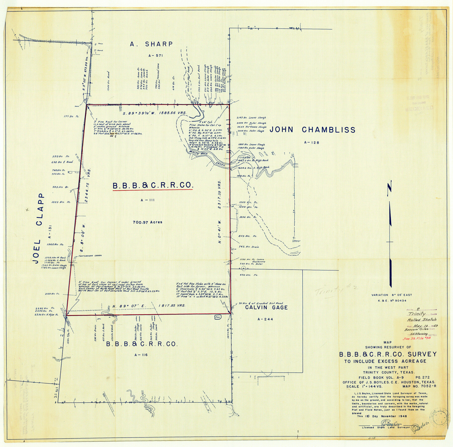
Trinity County Rolled Sketch 2
Map showing resurvey of B. B. B. & C. R.R. Co. survey to include excess acreage in the west part Trinity County, Texas
-
Map/Doc
10024
-
Collection
General Map Collection
-
Object Dates
1948/11/1 (Creation Date)
1949/5/10 (File Date)
-
People and Organizations
J.S. Boyles (Surveyor/Engineer)
-
Counties
Trinity
-
Subjects
Surveying Rolled Sketch
-
Height x Width
34.5 x 34.9 inches
87.6 x 88.6 cm
-
Medium
blueprint/diazo
-
Scale
1" = 144 varas
-
Comments
See Trinity County Sketch File 38 (38593) for report.
Related maps
Trinity County Sketch File 38

Print $8.00
- Digital $50.00
Trinity County Sketch File 38
1948
Size 14.5 x 8.9 inches
Map/Doc 38593
Part of: General Map Collection
Flight Mission No. DQO-3K, Frame 30, Galveston County

Print $20.00
- Digital $50.00
Flight Mission No. DQO-3K, Frame 30, Galveston County
1952
Size 18.9 x 22.4 inches
Map/Doc 85071
Tom Green County Sketch File 3

Print $20.00
- Digital $50.00
Tom Green County Sketch File 3
Size 29.7 x 40.5 inches
Map/Doc 10400
Harris County Rolled Sketch 63

Print $40.00
- Digital $50.00
Harris County Rolled Sketch 63
1936
Size 41.4 x 52.5 inches
Map/Doc 9120
Flight Mission No. CRC-3R, Frame 8, Chambers County

Print $20.00
- Digital $50.00
Flight Mission No. CRC-3R, Frame 8, Chambers County
1956
Size 18.6 x 22.2 inches
Map/Doc 84782
Padre Island National Seashore, Texas - Dependent Resurvey

Print $4.00
- Digital $50.00
Padre Island National Seashore, Texas - Dependent Resurvey
2001
Size 18.2 x 24.3 inches
Map/Doc 60552
Upton County Rolled Sketch 59

Print $40.00
- Digital $50.00
Upton County Rolled Sketch 59
1994
Size 35.8 x 49.2 inches
Map/Doc 10637
Boundary Between the United States & Mexico Agreed upon by the Joint Commission under the Treaty of Guadalupe Hidalgo

Print $4.00
- Digital $50.00
Boundary Between the United States & Mexico Agreed upon by the Joint Commission under the Treaty of Guadalupe Hidalgo
1853
Size 18.2 x 26.8 inches
Map/Doc 72879
Cooke County Boundary File 2

Print $19.00
- Digital $50.00
Cooke County Boundary File 2
Size 12.1 x 7.6 inches
Map/Doc 51840
Smith County Working Sketch 18

Print $40.00
- Digital $50.00
Smith County Working Sketch 18
1996
Size 50.4 x 37.1 inches
Map/Doc 63903
Pecos County Working Sketch 118

Print $20.00
- Digital $50.00
Pecos County Working Sketch 118
1973
Size 46.2 x 36.9 inches
Map/Doc 71591
Real County Working Sketch 12

Print $20.00
- Digital $50.00
Real County Working Sketch 12
1931
Size 19.1 x 18.6 inches
Map/Doc 71904
Irion County Boundary File 1

Print $36.00
- Digital $50.00
Irion County Boundary File 1
Size 8.9 x 4.1 inches
Map/Doc 55316
You may also like

General Highway Map, El Paso County, Texas

Print $20.00
General Highway Map, El Paso County, Texas
1961
Size 18.2 x 24.8 inches
Map/Doc 79458
Map of Pass Cavallo, Texas, Showing the position of the Rebel fortifications and rifle pits.

Print $20.00
Map of Pass Cavallo, Texas, Showing the position of the Rebel fortifications and rifle pits.
1863
Size 23.8 x 21.0 inches
Map/Doc 88595
Kenedy County Rolled Sketch 5

Print $20.00
- Digital $50.00
Kenedy County Rolled Sketch 5
1911
Size 27.9 x 24.4 inches
Map/Doc 6462
Outer Continental Shelf Leasing Maps (Texas Offshore Operations)

Print $20.00
- Digital $50.00
Outer Continental Shelf Leasing Maps (Texas Offshore Operations)
Size 29.9 x 21.7 inches
Map/Doc 75857
[Sketch for Mineral Application 13439 - Old River, Walle Merritt]
![65689, [Sketch for Mineral Application 13439 - Old River, Walle Merritt], General Map Collection](https://historictexasmaps.com/wmedia_w700/maps/65689-1.tif.jpg)
Print $20.00
- Digital $50.00
[Sketch for Mineral Application 13439 - Old River, Walle Merritt]
1925
Size 41.0 x 19.0 inches
Map/Doc 65689
Irion County Rolled Sketch 12

Print $40.00
- Digital $50.00
Irion County Rolled Sketch 12
1945
Size 37.5 x 51.9 inches
Map/Doc 75943
Dallam County Sketch File 13

Print $20.00
- Digital $50.00
Dallam County Sketch File 13
Size 22.2 x 20.3 inches
Map/Doc 11280
Blanco County Working Sketch 15

Print $20.00
- Digital $50.00
Blanco County Working Sketch 15
1950
Size 23.5 x 20.7 inches
Map/Doc 67375
Flight Mission No. CRC-3R, Frame 29, Chambers County

Print $20.00
- Digital $50.00
Flight Mission No. CRC-3R, Frame 29, Chambers County
1956
Size 18.6 x 22.3 inches
Map/Doc 84804
Ochiltree County

Print $20.00
- Digital $50.00
Ochiltree County
1889
Size 23.1 x 19.5 inches
Map/Doc 3923
Webb County Boundary File 6

Print $123.00
- Digital $50.00
Webb County Boundary File 6
Size 14.4 x 8.8 inches
Map/Doc 59786