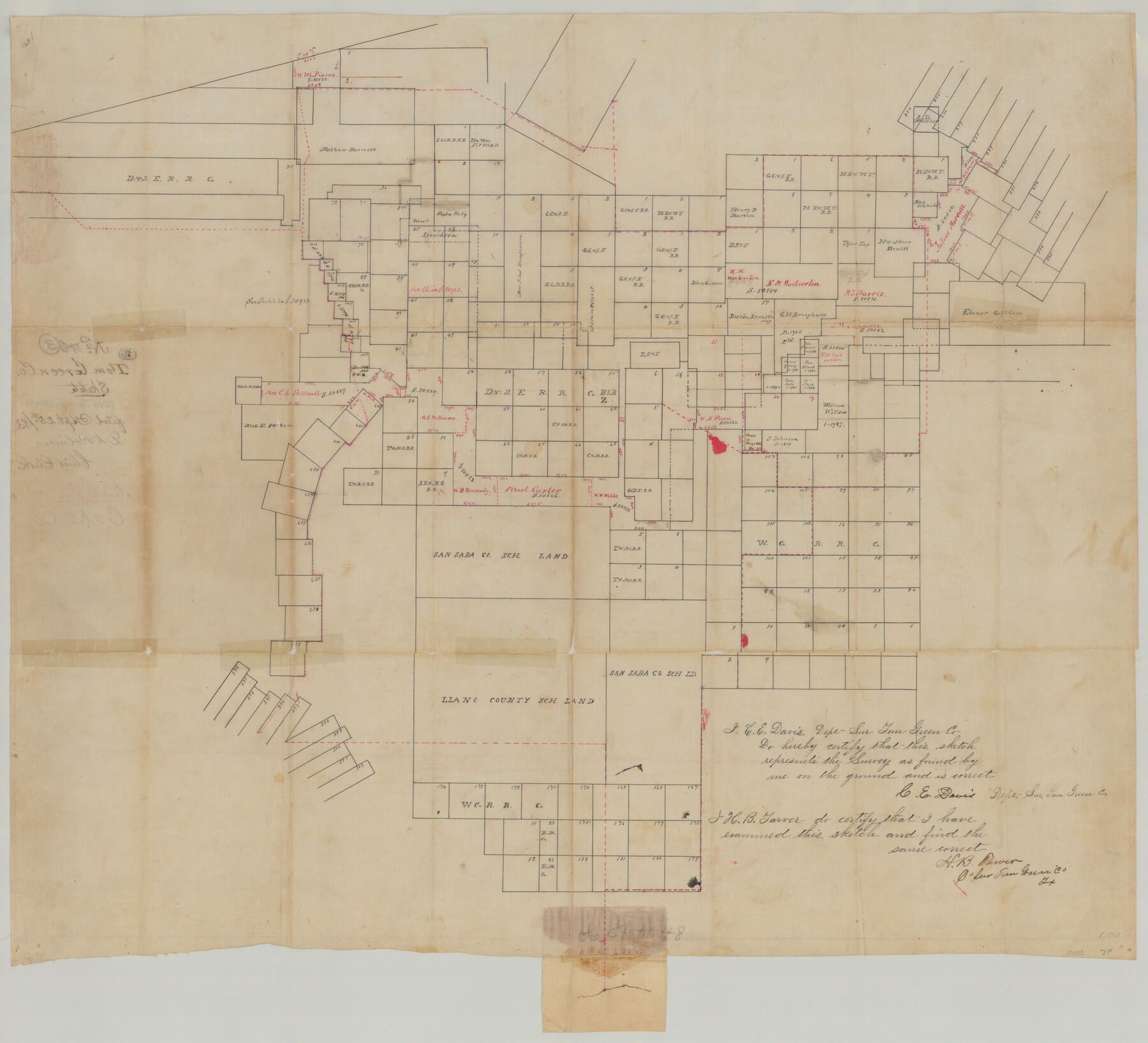
Tom Green County Sketch File 3
[Two sketches showing large area in the north part of Tom Green County and extending into Sterling and Coke Counties]
-
Map/Doc
10400
-
Collection
General Map Collection
-
Object Dates
9/25/1883 (File Date)
-
People and Organizations
C.E. Davis (Surveyor/Engineer)
-
Counties
Tom Green Sterling Coke
-
Subjects
Surveying Sketch File
-
Height x Width
29.7 x 40.5 inches
75.4 x 102.9 cm
-
Medium
paper, manuscript
Part of: General Map Collection
Flight Mission No. BRA-8M, Frame 129, Jefferson County

Print $20.00
- Digital $50.00
Flight Mission No. BRA-8M, Frame 129, Jefferson County
1953
Size 16.0 x 16.0 inches
Map/Doc 85625
Kaufman County Sketch File 18

Print $10.00
- Digital $50.00
Kaufman County Sketch File 18
1936
Size 11.4 x 8.8 inches
Map/Doc 28661
Dickens County Working Sketch 1

Print $20.00
- Digital $50.00
Dickens County Working Sketch 1
Size 15.5 x 15.5 inches
Map/Doc 68648
Matagorda County Rolled Sketch 40

Print $20.00
- Digital $50.00
Matagorda County Rolled Sketch 40
Size 24.6 x 27.4 inches
Map/Doc 6704
Crockett County Working Sketch 96

Print $20.00
- Digital $50.00
Crockett County Working Sketch 96
1979
Size 25.5 x 16.9 inches
Map/Doc 68429
Edwards County Rolled Sketch 23

Print $20.00
- Digital $50.00
Edwards County Rolled Sketch 23
1952
Size 26.3 x 34.7 inches
Map/Doc 8846
Panola County Rolled Sketch 4

Print $20.00
- Digital $50.00
Panola County Rolled Sketch 4
1951
Size 25.4 x 26.1 inches
Map/Doc 7198
Hutchinson County Rolled Sketch 23

Print $20.00
- Digital $50.00
Hutchinson County Rolled Sketch 23
1913
Size 29.7 x 25.6 inches
Map/Doc 6288
[Missouri, Kansas & Texas Line Map through Bastrop County]
![64033, [Missouri, Kansas & Texas Line Map through Bastrop County], General Map Collection](https://historictexasmaps.com/wmedia_w700/maps/64033.tif.jpg)
Print $40.00
- Digital $50.00
[Missouri, Kansas & Texas Line Map through Bastrop County]
1916
Size 25.2 x 68.9 inches
Map/Doc 64033
Cass County Working Sketch 29

Print $20.00
- Digital $50.00
Cass County Working Sketch 29
1979
Size 38.4 x 23.5 inches
Map/Doc 67932
Current Miscellaneous File 86

Print $6.00
- Digital $50.00
Current Miscellaneous File 86
Size 11.2 x 8.8 inches
Map/Doc 74240
Right-of-Way and Track Map, Houston and Brazos Valley Ry. Co. operated by the Houston and Brazos Valley Ry. Co.

Print $40.00
- Digital $50.00
Right-of-Way and Track Map, Houston and Brazos Valley Ry. Co. operated by the Houston and Brazos Valley Ry. Co.
1918
Size 24.9 x 56.4 inches
Map/Doc 64602
You may also like
Kimble County Working Sketch 34

Print $20.00
- Digital $50.00
Kimble County Working Sketch 34
1945
Size 34.4 x 26.7 inches
Map/Doc 70102

Angelina County Rolled Sketch 4

Print $20.00
- Digital $50.00
Angelina County Rolled Sketch 4
Size 24.9 x 36.9 inches
Map/Doc 77187
Flight Mission No. DCL-4C, Frame 120, Kenedy County

Print $20.00
- Digital $50.00
Flight Mission No. DCL-4C, Frame 120, Kenedy County
1943
Size 18.6 x 22.5 inches
Map/Doc 85819
Cameron County Rolled Sketch Z

Print $20.00
- Digital $50.00
Cameron County Rolled Sketch Z
1936
Size 24.6 x 31.3 inches
Map/Doc 5400
Flight Mission No. BRE-4P, Frame 170, Nueces County

Print $20.00
- Digital $50.00
Flight Mission No. BRE-4P, Frame 170, Nueces County
1956
Size 18.5 x 22.6 inches
Map/Doc 86833
Pecos County Sketch File 47

Print $8.00
- Digital $50.00
Pecos County Sketch File 47
1935
Size 11.4 x 8.5 inches
Map/Doc 33759
Calhoun County Rolled Sketch 26

Print $20.00
- Digital $50.00
Calhoun County Rolled Sketch 26
1941
Size 10.9 x 39.9 inches
Map/Doc 5374
Map of Hopkins County

Print $20.00
- Digital $50.00
Map of Hopkins County
1872
Size 17.5 x 17.9 inches
Map/Doc 4567
Hudspeth County Sketch File 1

Print $8.00
- Digital $50.00
Hudspeth County Sketch File 1
1900
Size 11.3 x 8.8 inches
Map/Doc 26880
Crockett County Rolled Sketch 88H

Print $40.00
- Digital $50.00
Crockett County Rolled Sketch 88H
1973
Size 42.6 x 57.3 inches
Map/Doc 8733
San Augustine County Working Sketch 1

Print $3.00
- Digital $50.00
San Augustine County Working Sketch 1
1906
Size 9.1 x 11.3 inches
Map/Doc 63688