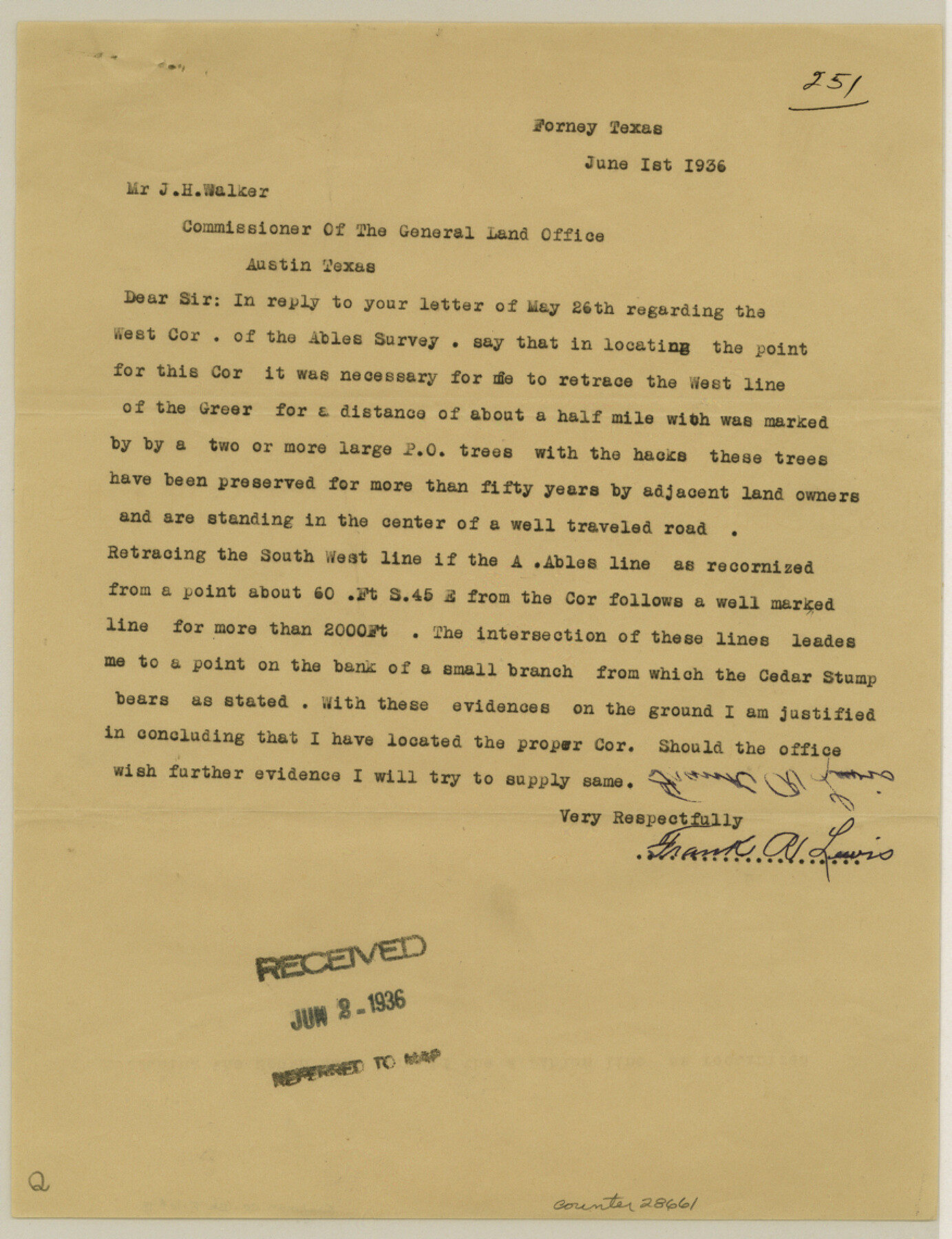
Kaufman County Sketch File 18
[Correspondence and affidavit regarding location of west corner of the Ables survey no. 86]
-
Map/Doc
28661
-
Collection
General Map Collection
-
Object Dates
6/1/1936 (Creation Date)
6/2/1936 (File Date)
5/26/1936 (Correspondence Date)
5/23/1936 (Correspondence Date)
5/1936 (Survey Date)
-
People and Organizations
Frank R. Lewis (Surveyor/Engineer)
-
Counties
Kaufman
-
Subjects
Surveying Sketch File
-
Height x Width
11.4 x 8.8 inches
29.0 x 22.4 cm
-
Medium
paper, print
Part of: General Map Collection

Atascosa County Sketch File 9

Print $4.00
- Digital $50.00
Atascosa County Sketch File 9
1858
Size 8.1 x 12.6 inches
Map/Doc 13763
Flight Mission No. BRA-16M, Frame 104, Jefferson County

Print $20.00
- Digital $50.00
Flight Mission No. BRA-16M, Frame 104, Jefferson County
1953
Size 18.5 x 22.3 inches
Map/Doc 85716
Flight Mission No. BRA-7M, Frame 181, Jefferson County

Print $20.00
- Digital $50.00
Flight Mission No. BRA-7M, Frame 181, Jefferson County
1953
Size 18.6 x 22.4 inches
Map/Doc 85549
Coast of Texas from head of East Bay Galveston Harbor to Sabine Pass

Print $40.00
- Digital $50.00
Coast of Texas from head of East Bay Galveston Harbor to Sabine Pass
1882
Size 32.3 x 53.9 inches
Map/Doc 69840
West Part Presidio Co.

Print $20.00
- Digital $50.00
West Part Presidio Co.
1974
Size 42.1 x 33.3 inches
Map/Doc 73267
A General Map of North America drawn from the best surveys

Print $20.00
- Digital $50.00
A General Map of North America drawn from the best surveys
1795
Map/Doc 93944
Hudspeth County Rolled Sketch 18

Print $40.00
- Digital $50.00
Hudspeth County Rolled Sketch 18
1886
Size 15.7 x 105.0 inches
Map/Doc 9204
Frio County Working Sketch 18

Print $20.00
- Digital $50.00
Frio County Working Sketch 18
1982
Size 35.7 x 36.8 inches
Map/Doc 69292
Webb County Rolled Sketch 5

Print $20.00
- Digital $50.00
Webb County Rolled Sketch 5
Size 43.2 x 23.0 inches
Map/Doc 8172

Archer County

Print $20.00
- Digital $50.00
Archer County
1926
Size 43.7 x 37.9 inches
Map/Doc 95419
You may also like
Jeff Davis County Sketch File 29

Print $30.00
- Digital $50.00
Jeff Davis County Sketch File 29
Size 14.2 x 8.5 inches
Map/Doc 28008
Webb County Working Sketch 27

Print $20.00
- Digital $50.00
Webb County Working Sketch 27
1932
Size 24.0 x 19.5 inches
Map/Doc 72392
Amistad International Reservoir on Rio Grande 74a

Print $20.00
- Digital $50.00
Amistad International Reservoir on Rio Grande 74a
1949
Size 28.6 x 40.0 inches
Map/Doc 75502
Scurry County Sketch File 3

Print $20.00
- Digital $50.00
Scurry County Sketch File 3
Size 22.0 x 24.2 inches
Map/Doc 12312
[George Gentry, Charles Welch, and Surrounding Surveys]
![91082, [George Gentry, Charles Welch, and Surrounding Surveys], Twichell Survey Records](https://historictexasmaps.com/wmedia_w700/maps/91082-1.tif.jpg)
Print $20.00
- Digital $50.00
[George Gentry, Charles Welch, and Surrounding Surveys]
1922
Size 28.6 x 32.0 inches
Map/Doc 91082
Nautical Chart 887-SC Intracoastal Waterway - Galveston Bay to Cedar Lakes including the Brazos and San Bernard Rivers, Texas

Print $40.00
- Digital $50.00
Nautical Chart 887-SC Intracoastal Waterway - Galveston Bay to Cedar Lakes including the Brazos and San Bernard Rivers, Texas
1971
Size 15.7 x 59.5 inches
Map/Doc 69938
Texas Gulf Coast Map from the Sabine River to the Rio Grande as subdivided for mineral development

Print $40.00
- Digital $50.00
Texas Gulf Coast Map from the Sabine River to the Rio Grande as subdivided for mineral development
1948
Size 44.0 x 69.2 inches
Map/Doc 2908
Lipscomb County Sketch File 6

Print $20.00
- Digital $50.00
Lipscomb County Sketch File 6
1965
Size 19.4 x 26.1 inches
Map/Doc 12005
Lamar County Texas

Print $20.00
- Digital $50.00
Lamar County Texas
1879
Size 23.4 x 18.3 inches
Map/Doc 3784
Jack County Sketch File 26

Print $4.00
- Digital $50.00
Jack County Sketch File 26
1891
Size 8.7 x 9.3 inches
Map/Doc 27563

Eastland County Working Sketch 21

Print $20.00
- Digital $50.00
Eastland County Working Sketch 21
1920
Size 15.4 x 22.7 inches
Map/Doc 68802