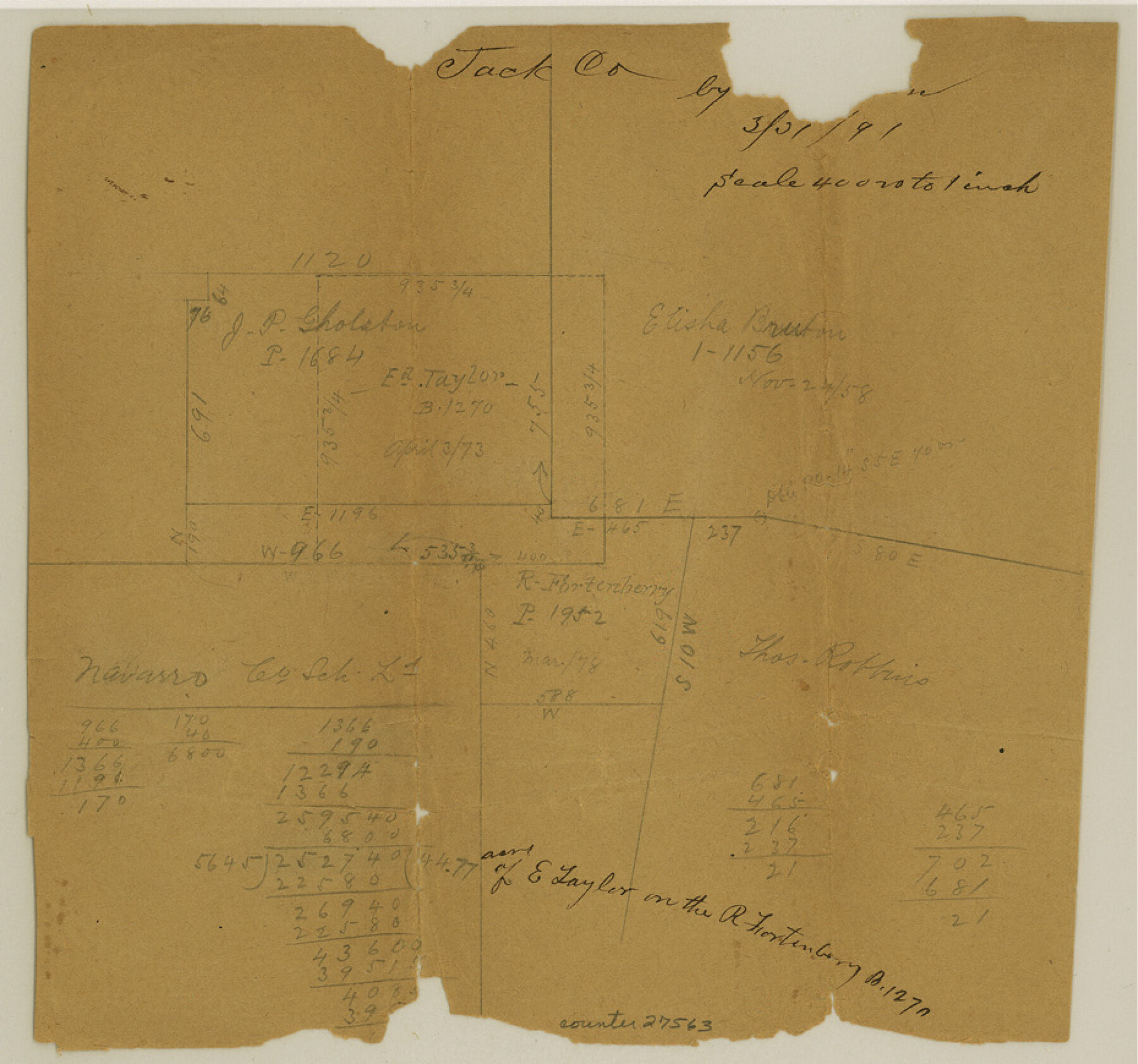
Jack County Sketch File 26
[Sketch southwest of Jacksboro]
- 
                          Map/Doc27563
- 
                            CollectionGeneral Map Collection
- 
                            Object Dates1891/3/31 (Creation Date)1891/3/31 (File Date)
- 
                            People and OrganizationsMcBean (Surveyor/Engineer)
- 
                            CountiesJack
- 
                            SubjectsSurveying Sketch File
- 
                            Height x Width8.7 x 9.3 inches22.1 x 23.6 cm
- 
                            Mediumpaper, manuscript
- 
                            Scale1:4000
Part of: General Map Collection
            Colorado County Sketch File 35


                                            Print $13.00                    
                                             -                         Digital $50.00                                    
                Colorado County Sketch File 35
2005
Size 44.0 x 28.0 inches
                                Map/Doc 83564
            
            Throckmorton County Boundary File 5


                                            Print $8.00                    
                                             -                         Digital $50.00                                    
                Throckmorton County Boundary File 5
Size 14.3 x 8.9 inches
                                Map/Doc 59286
            
            Intracoastal Waterway, Houma, LA to Corpus Christi, TX


                                            Print $20.00                    
                                             -                         Digital $50.00                                    
                Intracoastal Waterway, Houma, LA to Corpus Christi, TX
Size 18.9 x 27.9 inches
                                Map/Doc 61906
            
            Wharton County Working Sketch 18


                                            Print $20.00                    
                                             -                         Digital $50.00                                    
                Wharton County Working Sketch 18
1948
Size 19.3 x 17.0 inches
                                Map/Doc 72482
            
            Galveston County NRC Article 33.136 Sketch 33


                                            Print $20.00                    
                                             -                         Digital $50.00                                    
                Galveston County NRC Article 33.136 Sketch 33
2003
Size 42.5 x 30.9 inches
                                Map/Doc 83285
            
            Kinney County Working Sketch 10


                                            Print $20.00                    
                                             -                         Digital $50.00                                    
                Kinney County Working Sketch 10
1933
Size 23.1 x 18.4 inches
                                Map/Doc 70192
            
            Chicago, Rock Island, Texas & Mexico


                                            Print $40.00                    
                                             -                         Digital $50.00                                    
                Chicago, Rock Island, Texas & Mexico
1920
Size 24.8 x 122.0 inches
                                Map/Doc 64421
            
            Haskell County Working Sketch 10


                                            Print $20.00                    
                                             -                         Digital $50.00                                    
                Haskell County Working Sketch 10
1961
Size 26.8 x 20.4 inches
                                Map/Doc 66068
            
            Sutton County Rolled Sketch 53


                                            Print $20.00                    
                                             -                         Digital $50.00                                    
                Sutton County Rolled Sketch 53
1952
Size 23.4 x 15.5 inches
                                Map/Doc 7893
            
            Brown County Working Sketch 2


                                            Print $20.00                    
                                             -                         Digital $50.00                                    
                Brown County Working Sketch 2
1919
Size 17.0 x 17.5 inches
                                Map/Doc 67767
            
            [Three Mile Line and Three League Line]
            
                                    ![76120, [Three Mile Line and Three League Line], General Map Collection](https://historictexasmaps.com/wmedia_w700/maps/76120.tif.jpg) 


    ![76120, [Three Mile Line and Three League Line], General Map Collection](https://historictexasmaps.com/wmedia_w700/maps/76120.tif.jpg) 
                                
            
                                            Print $20.00                    
                                             -                         Digital $50.00                                    
                [Three Mile Line and Three League Line]
1973
Size 43.2 x 33.3 inches
                                Map/Doc 76120
            You may also like
            [Sections 29-32 in CRR Block 49, Miguel Tafoya Survey 1 Block MT, and vicinity]
            
                                    ![90667, [Sections 29-32 in CRR Block 49, Miguel Tafoya Survey 1 Block MT, and vicinity], Twichell Survey Records](https://historictexasmaps.com/wmedia_w700/maps/90667-1.tif.jpg) 


    ![90667, [Sections 29-32 in CRR Block 49, Miguel Tafoya Survey 1 Block MT, and vicinity], Twichell Survey Records](https://historictexasmaps.com/wmedia_w700/maps/90667-1.tif.jpg) 
                                
            
                                            Print $20.00                    
                                             -                         Digital $50.00                                    
                [Sections 29-32 in CRR Block 49, Miguel Tafoya Survey 1 Block MT, and vicinity]
Size 23.4 x 21.0 inches
                                Map/Doc 90667
            
            Brazoria County Working Sketch 11


                                            Print $20.00                    
                                             -                         Digital $50.00                                    
                Brazoria County Working Sketch 11
1935
Size 18.1 x 24.3 inches
                                Map/Doc 67496
            
            Van Zandt County Sketch File 20


                                            Print $4.00                    
                                             -                         Digital $50.00                                    
                Van Zandt County Sketch File 20
1858
Size 12.1 x 7.9 inches
                                Map/Doc 39426
            
            Map of Mason County


                                            Print $20.00                    
                                             -                         Digital $50.00                                    
                Map of Mason County
1859
Size 28.4 x 22.4 inches
                                Map/Doc 3838
            
            Nueces County Rolled Sketch 49


                                            Print $20.00                    
                                             -                         Digital $50.00                                    
                Nueces County Rolled Sketch 49
1979
Size 21.1 x 20.7 inches
                                Map/Doc 6888
            
            Galveston County Working Sketch 22


                                            Print $20.00                    
                                             -                         Digital $50.00                                    
                Galveston County Working Sketch 22
1988
Size 27.4 x 38.3 inches
                                Map/Doc 69359
            
            Zavala County Sketch File 23


                                            Print $4.00                    
                                             -                         Digital $50.00                                    
                Zavala County Sketch File 23
1885
Size 14.4 x 8.8 inches
                                Map/Doc 41380
            
            Map of Galveston County


                                            Print $20.00                    
                                             -                         Digital $50.00                                    
                Map of Galveston County
1883
Size 18.8 x 26.8 inches
                                Map/Doc 3573
            
            Rand, McNally and Co.'s New Enlarged Scale Railroad and County Map of Texas, Showing Every Railroad Station and Post Office in the State


                                            Print $20.00                    
                                             -                         Digital $50.00                                    
                Rand, McNally and Co.'s New Enlarged Scale Railroad and County Map of Texas, Showing Every Railroad Station and Post Office in the State
1882
Size 23.7 x 29.8 inches
                                Map/Doc 2135
            
            Meanders of Sulphur Fork of Red River, Red River County, Texas


                                            Print $2.00                    
                                             -                         Digital $50.00                                    
                Meanders of Sulphur Fork of Red River, Red River County, Texas
1841
Size 9.9 x 8.1 inches
                                Map/Doc 65785
            
            Official Map of the State of Texas to accompany the Statistical and Descriptive Work, "Resources, Soil and Climate of Texas"


                                            Print $20.00                    
                                             -                         Digital $50.00                                    
                Official Map of the State of Texas to accompany the Statistical and Descriptive Work, "Resources, Soil and Climate of Texas"
1882
Size 31.1 x 33.1 inches
                                Map/Doc 2134
            
            Map of subdivision of submerged land in the Gulf of Mexico fronting on Matagorda Island and Peninsula


                                            Print $40.00                    
                                             -                         Digital $50.00                                    
                Map of subdivision of submerged land in the Gulf of Mexico fronting on Matagorda Island and Peninsula
1940
Size 22.8 x 76.5 inches
                                Map/Doc 2932
             
                            