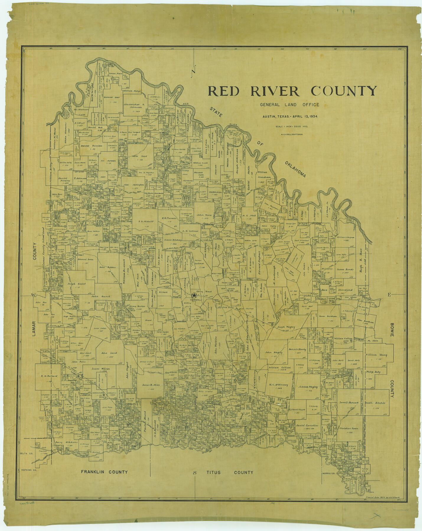
Red River County
-
Map/Doc
66995
-
Collection
General Map Collection
-
Object Dates
1934/4/13 (Creation Date)
-
People and Organizations
Texas General Land Office (Publisher)
W.S. Vines (Draftsman)
W.S. Vines (Compiler)
-
Counties
Red River
-
Subjects
County
-
Height x Width
52.0 x 41.3 inches
132.1 x 104.9 cm
-
Comments
Traced in June 1934 by A. C. Clark.
Part of: General Map Collection
Right of Way and Track Map International & Gt. Northern Ry. operated by the International & Gt. Northern Ry. Co., Columbia Branch, Gulf Division

Print $40.00
- Digital $50.00
Right of Way and Track Map International & Gt. Northern Ry. operated by the International & Gt. Northern Ry. Co., Columbia Branch, Gulf Division
1917
Size 25.1 x 56.7 inches
Map/Doc 64597
Sabine and Neches Rivers

Print $20.00
- Digital $50.00
Sabine and Neches Rivers
1925
Size 19.6 x 44.0 inches
Map/Doc 69816
Henderson County Working Sketch 29

Print $20.00
- Digital $50.00
Henderson County Working Sketch 29
1961
Size 39.3 x 41.9 inches
Map/Doc 66162
Duval County Sketch File 54

Print $20.00
- Digital $50.00
Duval County Sketch File 54
1937
Size 19.0 x 26.4 inches
Map/Doc 11403
Map of Harrison County

Print $20.00
- Digital $50.00
Map of Harrison County
1840
Size 44.6 x 34.5 inches
Map/Doc 1515
Montgomery County Rolled Sketch 40A

Print $40.00
- Digital $50.00
Montgomery County Rolled Sketch 40A
1970
Size 40.4 x 57.5 inches
Map/Doc 9547
Tom Green Co.

Print $40.00
- Digital $50.00
Tom Green Co.
1887
Size 42.0 x 110.7 inches
Map/Doc 76034
Crockett County Working Sketch 88

Print $20.00
- Digital $50.00
Crockett County Working Sketch 88
1976
Size 34.0 x 32.9 inches
Map/Doc 68421
Brazoria County Sketch File 58

Print $30.00
- Digital $50.00
Brazoria County Sketch File 58
1992
Size 11.5 x 9.0 inches
Map/Doc 15382
Harris County Sketch File B

Print $4.00
- Digital $50.00
Harris County Sketch File B
1860
Size 8.0 x 5.5 inches
Map/Doc 25309
Mills County Sketch File A

Print $4.00
- Digital $50.00
Mills County Sketch File A
1890
Size 8.9 x 11.0 inches
Map/Doc 31646
Angelina County Sketch File 18c

Print $4.00
- Digital $50.00
Angelina County Sketch File 18c
Size 12.8 x 8.3 inches
Map/Doc 13034
You may also like
Orange County Working Sketch 34

Print $20.00
- Digital $50.00
Orange County Working Sketch 34
1958
Size 34.8 x 26.7 inches
Map/Doc 71366
Ft. W. & R. G. Ry. Right of Way Map, Chapin to Bluffdale, Hood County, Texas

Print $40.00
- Digital $50.00
Ft. W. & R. G. Ry. Right of Way Map, Chapin to Bluffdale, Hood County, Texas
1918
Size 37.3 x 120.2 inches
Map/Doc 64642
Map of Hamilton County

Print $20.00
- Digital $50.00
Map of Hamilton County
1863
Size 22.8 x 25.8 inches
Map/Doc 3621
Map of Nacogdoches County

Print $20.00
- Digital $50.00
Map of Nacogdoches County
1881
Size 24.1 x 21.5 inches
Map/Doc 4605
Andrews County Rolled Sketch 41

Print $20.00
- Digital $50.00
Andrews County Rolled Sketch 41
Size 18.0 x 24.0 inches
Map/Doc 77181

Bell County Sketch File 25

Print $8.00
- Digital $50.00
Bell County Sketch File 25
Size 5.1 x 5.3 inches
Map/Doc 14420
Culberson County Sketch File 32

Print $22.00
- Digital $50.00
Culberson County Sketch File 32
1952
Size 11.2 x 8.7 inches
Map/Doc 20285
Presidio County Working Sketch 132

Print $20.00
- Digital $50.00
Presidio County Working Sketch 132
1989
Size 36.7 x 29.4 inches
Map/Doc 71810
Cooke County Sketch File 28

Print $4.00
- Digital $50.00
Cooke County Sketch File 28
1872
Size 12.8 x 8.5 inches
Map/Doc 19281

Flight Mission No. CGN-3P, Frame 23, San Patricio County

Print $20.00
- Digital $50.00
Flight Mission No. CGN-3P, Frame 23, San Patricio County
1956
Size 18.6 x 22.2 inches
Map/Doc 86981