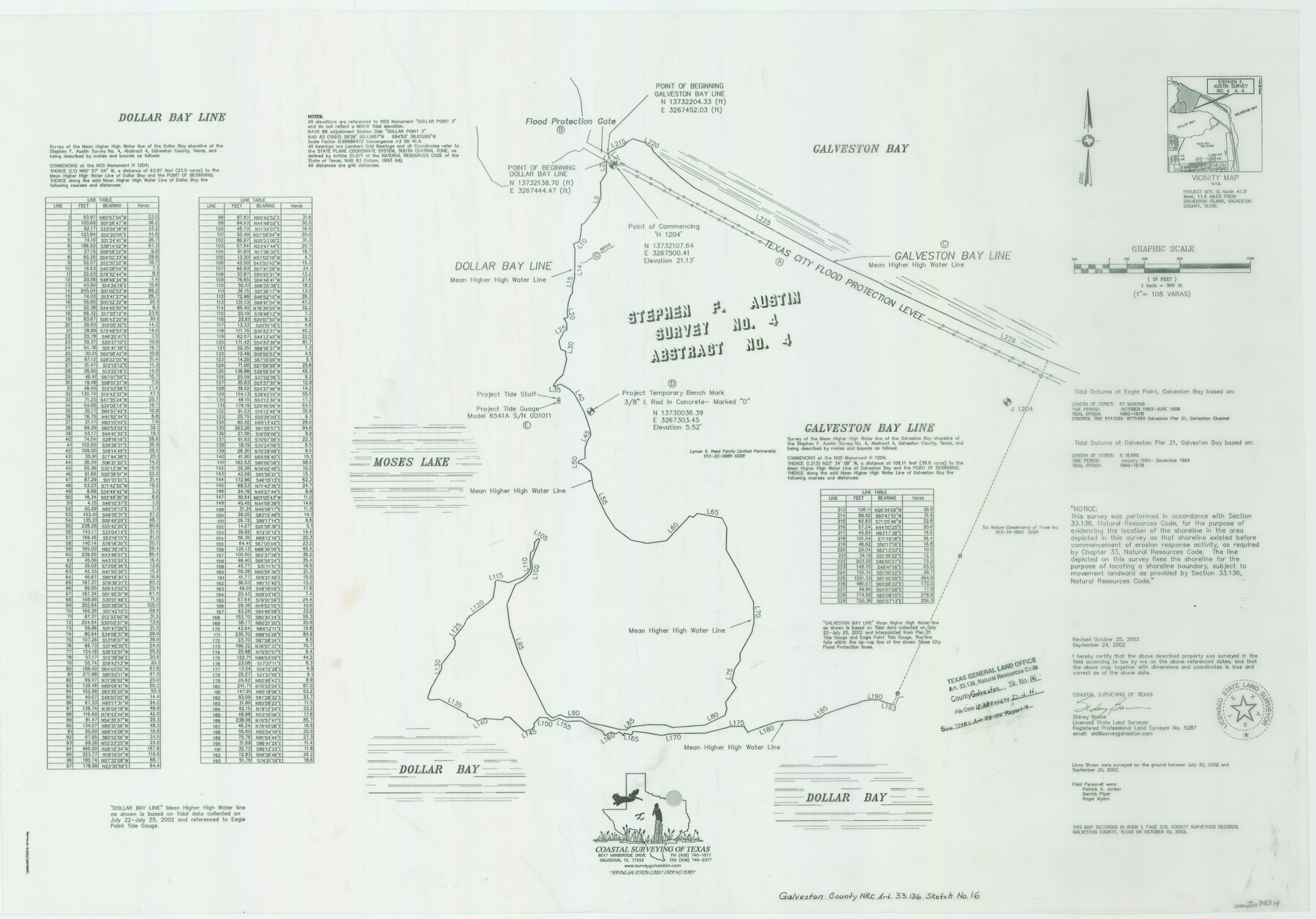
Galveston County NRC Article 33.136 Sketch 16
Mean Higher High Water Line Survey of the Stephen F. Austin Survey 4, Abstract 4
-
Map/Doc
78314
-
Collection
General Map Collection
-
Object Dates
2002/10/25 (Creation Date)
2002/12/30 (File Date)
-
People and Organizations
Coastal Surveying of Texas (Publisher)
Coastal Surveying of Texas (Printer)
Sidney Bouse (Surveyor/Engineer)
-
Counties
Galveston
-
Subjects
Surveying CBS
-
Height x Width
25.3 x 36.2 inches
64.3 x 91.9 cm
-
Medium
multi-page, multi-format
-
Comments
Survey located about 12 miles North 40 degrees West of Galveston, Texas.
One or more items in this file were formerly filed in another file. They have been reunited in this file with their original grouping. The old name on these sheets has been cros
Part of: General Map Collection
Bee County Working Sketch 2

Print $3.00
- Digital $50.00
Bee County Working Sketch 2
1914
Size 11.0 x 9.6 inches
Map/Doc 67252
Map of Clemens State Farm, Brazoria County, Texas

Print $20.00
- Digital $50.00
Map of Clemens State Farm, Brazoria County, Texas
1934
Size 31.2 x 36.1 inches
Map/Doc 62984
Chambers County Sketch File 55

Print $10.00
- Digital $50.00
Chambers County Sketch File 55
1935
Size 14.3 x 8.6 inches
Map/Doc 18094
[Gulf, Colorado & Santa Fe]
![64577, [Gulf, Colorado & Santa Fe], General Map Collection](https://historictexasmaps.com/wmedia_w700/maps/64577.tif.jpg)
Print $20.00
- Digital $50.00
[Gulf, Colorado & Santa Fe]
Size 32.4 x 47.4 inches
Map/Doc 64577
Sketch E. No. 2 Shewing the progress of the Survey in the vicinity of Savannah, Georgia

Print $20.00
- Digital $50.00
Sketch E. No. 2 Shewing the progress of the Survey in the vicinity of Savannah, Georgia
1850
Size 11.0 x 9.9 inches
Map/Doc 97214
Runnels County

Print $20.00
- Digital $50.00
Runnels County
1948
Size 46.5 x 36.4 inches
Map/Doc 77411
Presidio County Sketch File 35B

Print $20.00
- Digital $50.00
Presidio County Sketch File 35B
1906
Size 11.8 x 20.7 inches
Map/Doc 11714

[Cotton Belt, St. Louis Southwestern Railway of Texas, Alignment through Smith County]
![64385, [Cotton Belt, St. Louis Southwestern Railway of Texas, Alignment through Smith County], General Map Collection](https://historictexasmaps.com/wmedia_w700/maps/64385.tif.jpg)
Print $20.00
- Digital $50.00
[Cotton Belt, St. Louis Southwestern Railway of Texas, Alignment through Smith County]
1903
Size 21.6 x 29.8 inches
Map/Doc 64385
Fisher County Working Sketch 9

Print $20.00
- Digital $50.00
Fisher County Working Sketch 9
1947
Size 18.1 x 17.9 inches
Map/Doc 69143
Travis County Rolled Sketch 47

Print $40.00
- Digital $50.00
Travis County Rolled Sketch 47
1923
Size 57.3 x 26.5 inches
Map/Doc 10626
Nueces County Working Sketch 12

Print $20.00
- Digital $50.00
Nueces County Working Sketch 12
2011
Size 22.0 x 42.3 inches
Map/Doc 90047
You may also like
Pecos County Working Sketch 126

Print $40.00
- Digital $50.00
Pecos County Working Sketch 126
1974
Size 83.6 x 38.2 inches
Map/Doc 71599
Guadalupe County Sketch File 21

Print $6.00
- Digital $50.00
Guadalupe County Sketch File 21
Size 9.9 x 8.5 inches
Map/Doc 24702
Brewster County Sketch File FN-32

Print $8.00
- Digital $50.00
Brewster County Sketch File FN-32
Size 11.1 x 8.7 inches
Map/Doc 15854
Pecos County Rolled Sketch JAS

Print $20.00
- Digital $50.00
Pecos County Rolled Sketch JAS
1937
Size 34.9 x 31.4 inches
Map/Doc 9744
Brazoria County Working Sketch 20

Print $40.00
- Digital $50.00
Brazoria County Working Sketch 20
1951
Size 50.3 x 42.9 inches
Map/Doc 67505
Jim Hogg County Working Sketch 12

Print $20.00
- Digital $50.00
Jim Hogg County Working Sketch 12
1984
Size 17.4 x 15.2 inches
Map/Doc 66598
Crockett County Working Sketch 43

Print $20.00
- Digital $50.00
Crockett County Working Sketch 43
1931
Size 26.1 x 21.7 inches
Map/Doc 68376
Kinney County Sketch File 16

Print $20.00
- Digital $50.00
Kinney County Sketch File 16
1887
Size 23.2 x 25.4 inches
Map/Doc 11941
Plat in Pecos County, Texas

Print $40.00
- Digital $50.00
Plat in Pecos County, Texas
1927
Size 58.3 x 37.9 inches
Map/Doc 89877
Topographical Map of the Rio Grande, Sheet No. 26

Print $20.00
- Digital $50.00
Topographical Map of the Rio Grande, Sheet No. 26
1912
Map/Doc 89550
[University Lands in West Texas]
![2422, [University Lands in West Texas], General Map Collection](https://historictexasmaps.com/wmedia_w700/maps/2422.tif.jpg)
Print $20.00
- Digital $50.00
[University Lands in West Texas]
1938
Size 20.3 x 28.1 inches
Map/Doc 2422
Baylor County Sketch File Z5

Print $4.00
- Digital $50.00
Baylor County Sketch File Z5
1902
Size 11.5 x 8.9 inches
Map/Doc 14115