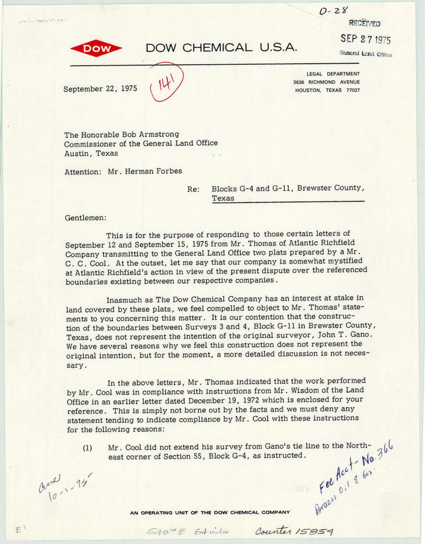
Brewster County Sketch File FN-32
[Correspondence of protest by Dow Chemical regarding Blocks G-4 and G-11]
-
Map/Doc
15854
-
Collection
General Map Collection
-
Object Dates
1972/12/19 (Correspondence Date)
1975/9/22 (Correspondence Date)
1975/9/27 (File Date)
-
People and Organizations
Karl R. Nordquist (Author)
C.C. Cool (Surveyor/Engineer)
-
Counties
Brewster
-
Subjects
Surveying Sketch File
-
Height x Width
11.1 x 8.7 inches
28.2 x 22.1 cm
-
Medium
paper, print
Part of: General Map Collection
Hardin County Sketch File 70

Print $4.00
- Digital $50.00
Hardin County Sketch File 70
1895
Size 11.2 x 9.0 inches
Map/Doc 25257
Galveston County Working Sketch 2

Print $20.00
- Digital $50.00
Galveston County Working Sketch 2
1924
Size 24.1 x 26.3 inches
Map/Doc 69339
Montague County Working Sketch 18

Print $20.00
- Digital $50.00
Montague County Working Sketch 18
1948
Size 27.9 x 21.4 inches
Map/Doc 71084
Duval County Sketch File 6b

Print $5.00
- Digital $50.00
Duval County Sketch File 6b
1875
Size 8.3 x 10.8 inches
Map/Doc 21290
Presidio County Rolled Sketch 144

Print $20.00
- Digital $50.00
Presidio County Rolled Sketch 144
2010
Size 36.0 x 24.0 inches
Map/Doc 89603
Uvalde County Working Sketch 66

Print $20.00
- Digital $50.00
Uvalde County Working Sketch 66
1942
Size 20.9 x 21.3 inches
Map/Doc 75968
Hopkins County

Print $20.00
- Digital $50.00
Hopkins County
1942
Size 43.6 x 41.6 inches
Map/Doc 1858
Flight Mission No. BRE-1P, Frame 34, Nueces County

Print $20.00
- Digital $50.00
Flight Mission No. BRE-1P, Frame 34, Nueces County
1956
Size 18.4 x 22.2 inches
Map/Doc 86630
Van Zandt County Boundary File 2

Print $32.00
- Digital $50.00
Van Zandt County Boundary File 2
Size 13.0 x 8.1 inches
Map/Doc 59633
Bailey County Sketch File 18

Print $40.00
- Digital $50.00
Bailey County Sketch File 18
Size 13.3 x 22.9 inches
Map/Doc 10889

Lampasas County Working Sketch 20

Print $20.00
- Digital $50.00
Lampasas County Working Sketch 20
1981
Size 26.0 x 31.9 inches
Map/Doc 70297
You may also like
Hemphill County Working Sketch 36

Print $40.00
- Digital $50.00
Hemphill County Working Sketch 36
1978
Size 38.3 x 51.7 inches
Map/Doc 66131
Map of Atascosa County, Texas

Print $20.00
- Digital $50.00
Map of Atascosa County, Texas
1916
Size 30.0 x 28.6 inches
Map/Doc 9006
Galveston Bay and Approaches

Print $20.00
- Digital $50.00
Galveston Bay and Approaches
1966
Size 43.3 x 32.6 inches
Map/Doc 69879
Colorado County Working Sketch 35

Print $20.00
- Digital $50.00
Colorado County Working Sketch 35
Size 19.8 x 15.8 inches
Map/Doc 76065
Crockett County Working Sketch 50

Print $20.00
- Digital $50.00
Crockett County Working Sketch 50
1940
Size 30.3 x 24.9 inches
Map/Doc 68383
Concho County Sketch File 43

Print $6.00
- Digital $50.00
Concho County Sketch File 43
1948
Size 14.4 x 8.9 inches
Map/Doc 19204
Tyler County Sketch File 10

Print $4.00
- Digital $50.00
Tyler County Sketch File 10
Size 8.6 x 6.7 inches
Map/Doc 38648
Mills County Boundary File 8

Print $10.00
- Digital $50.00
Mills County Boundary File 8
Size 14.2 x 8.7 inches
Map/Doc 57313

Brazoria County Sketch File 2

Print $6.00
- Digital $50.00
Brazoria County Sketch File 2
Size 8.0 x 3.3 inches
Map/Doc 14920
Cochran County Rolled Sketch 1

Print $40.00
- Digital $50.00
Cochran County Rolled Sketch 1
1938
Size 61.8 x 18.0 inches
Map/Doc 8606
Gray County Boundary File 8

Print $4.00
- Digital $50.00
Gray County Boundary File 8
Size 14.5 x 9.1 inches
Map/Doc 53900