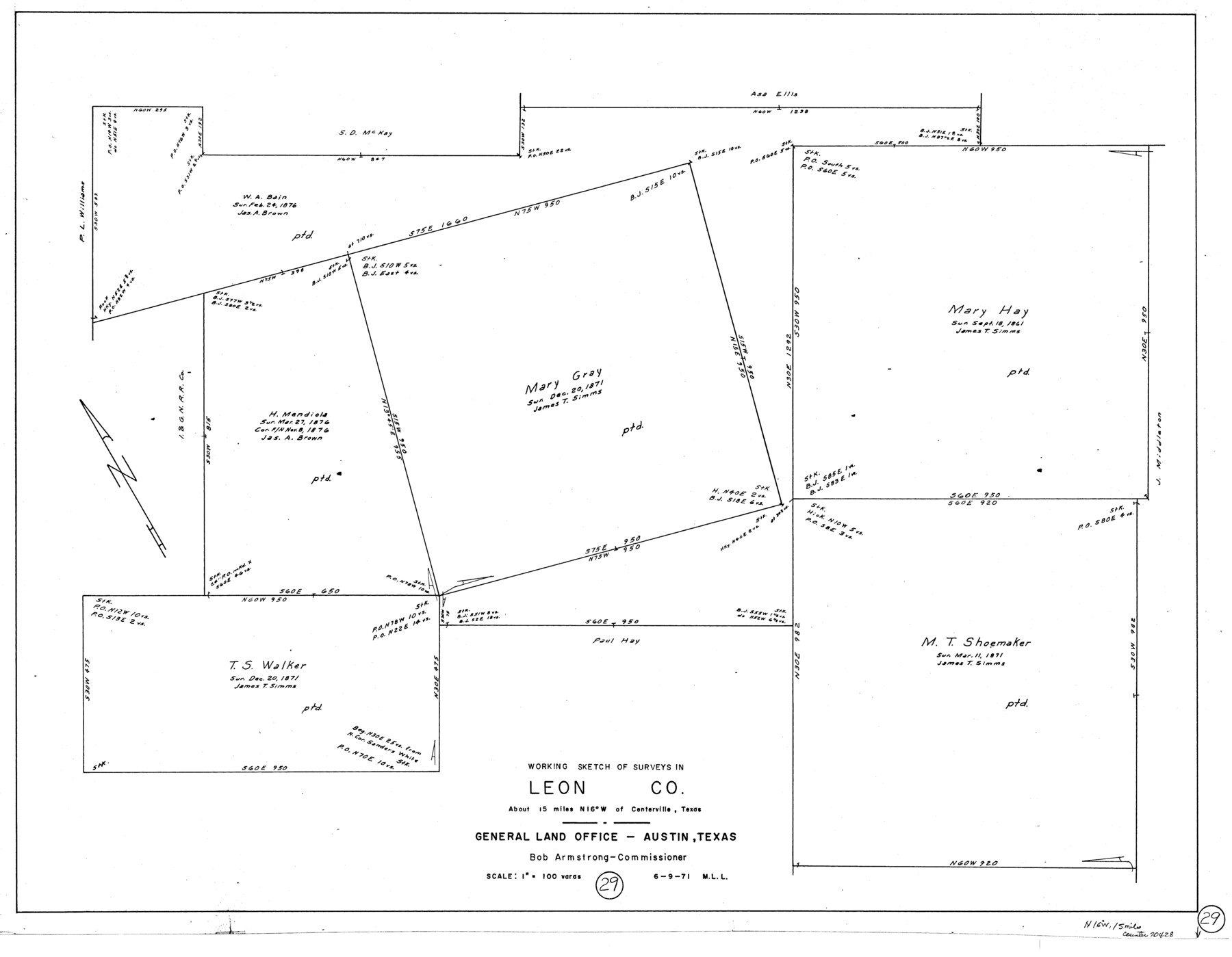
Leon County Working Sketch 29
-
Map/Doc
70428
-
Collection
General Map Collection
-
Object Dates
6/9/1971 (Creation Date)
-
People and Organizations
M. L. Liles (Draftsman)
-
Counties
Leon
-
Subjects
Surveying Working Sketch
-
Height x Width
25.8 x 33.1 inches
65.5 x 84.1 cm
-
Scale
1" = 100 varas
Part of: General Map Collection
No. 1. Outline Map of the Rio Grande from its mouth up to Ringold Barracks

Print $20.00
- Digital $50.00
No. 1. Outline Map of the Rio Grande from its mouth up to Ringold Barracks
Size 24.5 x 18.3 inches
Map/Doc 72858
Crockett County Rolled Sketch 92

Print $20.00
- Digital $50.00
Crockett County Rolled Sketch 92
1977
Size 43.0 x 25.2 inches
Map/Doc 5632
Gray County Sketch File 11

Print $40.00
- Digital $50.00
Gray County Sketch File 11
Size 15.0 x 13.5 inches
Map/Doc 24452
Parker County Sketch File 38

Print $20.00
- Digital $50.00
Parker County Sketch File 38
Size 21.7 x 13.3 inches
Map/Doc 12149
Midland County Sketch File 3

Print $20.00
- Digital $50.00
Midland County Sketch File 3
1886
Size 18.3 x 25.2 inches
Map/Doc 12081
Map of Young County East of the Main Brazos River formerly Fannin and West of it Milam Land District

Print $20.00
- Digital $50.00
Map of Young County East of the Main Brazos River formerly Fannin and West of it Milam Land District
1859
Size 23.3 x 20.2 inches
Map/Doc 4173
Trinity County Working Sketch Graphic Index

Print $20.00
- Digital $50.00
Trinity County Working Sketch Graphic Index
1946
Size 41.3 x 41.6 inches
Map/Doc 76718
Smith County Working Sketch 19

Print $20.00
- Digital $50.00
Smith County Working Sketch 19
1997
Size 31.4 x 36.5 inches
Map/Doc 63904
Fractional Township No. 1N and Township No. 2N R. No. 2E, Deaf Smith and Parmer Counties comprising Capitol Leagues 439 and 452 and parts of Capitol Leagues 431, 432, 433, 438, 440, 451, 453, 458, 459, and 460

Print $20.00
- Digital $50.00
Fractional Township No. 1N and Township No. 2N R. No. 2E, Deaf Smith and Parmer Counties comprising Capitol Leagues 439 and 452 and parts of Capitol Leagues 431, 432, 433, 438, 440, 451, 453, 458, 459, and 460
1906
Size 27.1 x 22.4 inches
Map/Doc 93966

Old Miscellaneous File 12

Print $14.00
- Digital $50.00
Old Miscellaneous File 12
1899
Size 14.2 x 8.6 inches
Map/Doc 75439
Sabine Bank to East Bay including Heald Bank

Print $20.00
- Digital $50.00
Sabine Bank to East Bay including Heald Bank
1976
Size 45.0 x 34.5 inches
Map/Doc 69851
You may also like
Goliad County Sketch File 30

Print $40.00
- Digital $50.00
Goliad County Sketch File 30
Size 13.0 x 15.0 inches
Map/Doc 24327
Floyd County Rolled Sketch 11

Print $20.00
- Digital $50.00
Floyd County Rolled Sketch 11
2000
Size 15.5 x 20.9 inches
Map/Doc 5884
Hudspeth County Rolled Sketch 69

Print $20.00
- Digital $50.00
Hudspeth County Rolled Sketch 69
1973
Size 12.3 x 19.2 inches
Map/Doc 7718
Lynn County Rolled Sketch H

Print $20.00
- Digital $50.00
Lynn County Rolled Sketch H
1902
Size 43.6 x 38.4 inches
Map/Doc 9472
The Beautiful Valley of the Lower Rio Grande of Texas

The Beautiful Valley of the Lower Rio Grande of Texas
1928
Map/Doc 96739
Hemphill County Working Sketch 38

Print $20.00
- Digital $50.00
Hemphill County Working Sketch 38
1982
Size 29.9 x 27.8 inches
Map/Doc 66133
Montague County Sketch File 28

Print $4.00
- Digital $50.00
Montague County Sketch File 28
1963
Size 18.7 x 22.6 inches
Map/Doc 12110
[Surveys along Tehuacano and Grindstone Creek, drawings X and Y]
![299, [Surveys along Tehuacano and Grindstone Creek, drawings X and Y], General Map Collection](https://historictexasmaps.com/wmedia_w700/maps/299.tif.jpg)
Print $20.00
- Digital $50.00
[Surveys along Tehuacano and Grindstone Creek, drawings X and Y]
1846
Size 12.4 x 18.3 inches
Map/Doc 299
Wichita County Working Sketch 2

Print $20.00
- Digital $50.00
Wichita County Working Sketch 2
1913
Size 20.0 x 18.7 inches
Map/Doc 72511
Crockett County Sketch File 35b

Print $20.00
- Digital $50.00
Crockett County Sketch File 35b
Size 13.9 x 8.8 inches
Map/Doc 19736
Milam County Rolled Sketch 3C

Print $20.00
- Digital $50.00
Milam County Rolled Sketch 3C
1959
Size 21.8 x 18.4 inches
Map/Doc 6776
Map of Anderson County

Print $20.00
- Digital $50.00
Map of Anderson County
1895
Size 40.9 x 45.4 inches
Map/Doc 4784