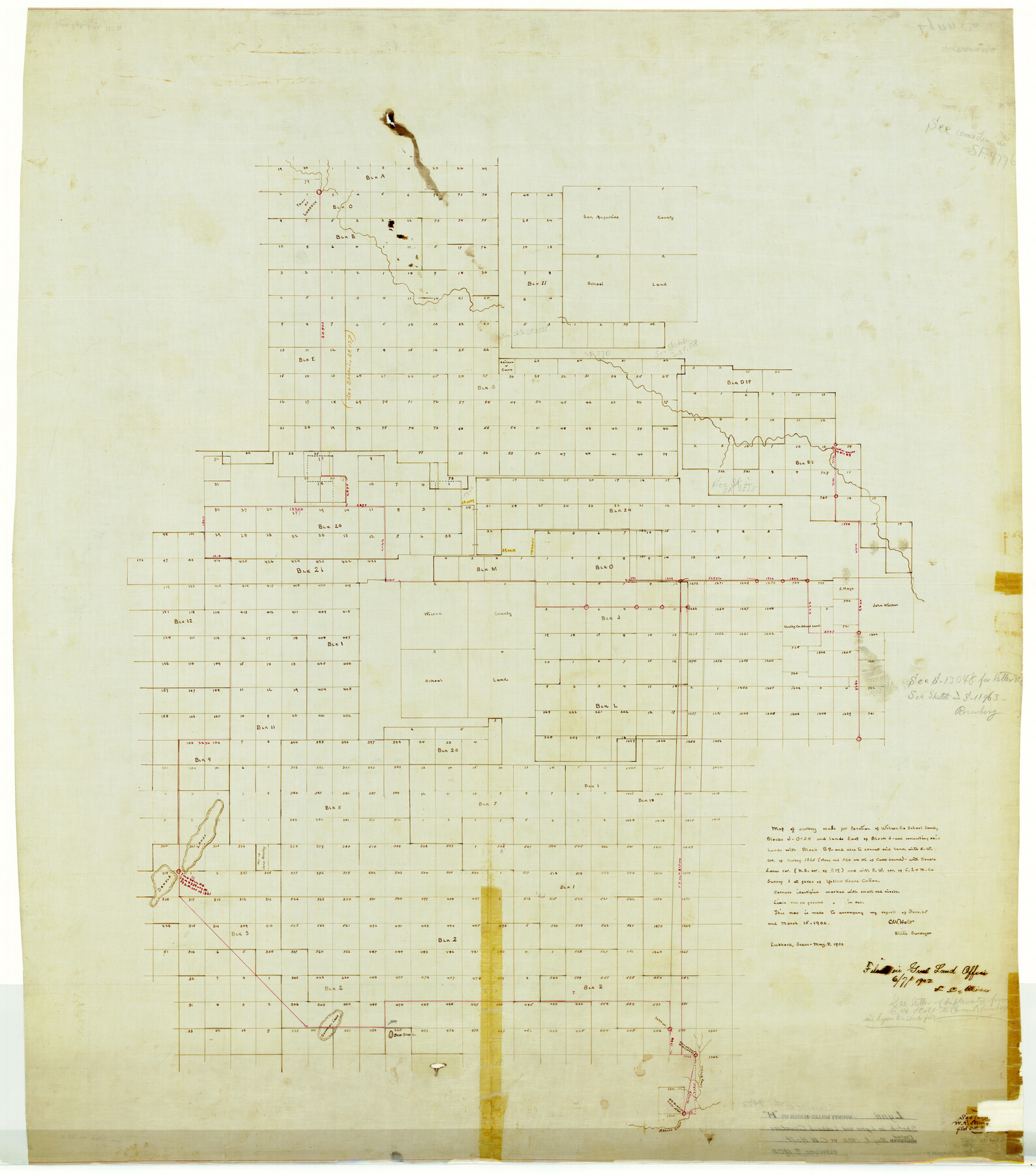
Lynn County Rolled Sketch H
Map of survey made for location of Wilson Co. School Land Blocks J, O, 24 and lands east of Block J and connecting said lands with Block B9
-
Map/Doc
9472
-
Collection
General Map Collection
-
Object Dates
1902/5/8 (Creation Date)
1902/6/7 (File Date)
-
People and Organizations
C.W. Holt (Surveyor/Engineer)
-
Counties
Lynn Lubbock
-
Subjects
Surveying Rolled Sketch
-
Height x Width
43.6 x 38.4 inches
110.7 x 97.5 cm
-
Medium
linen, manuscript
Part of: General Map Collection
Terrell County

Print $20.00
- Digital $50.00
Terrell County
1931
Size 40.0 x 33.4 inches
Map/Doc 77433
Hunt County Sketch File 2

Print $4.00
- Digital $50.00
Hunt County Sketch File 2
1857
Size 10.1 x 7.8 inches
Map/Doc 27083
Bowie County Working Sketch Graphic Index

Print $20.00
- Digital $50.00
Bowie County Working Sketch Graphic Index
1933
Size 38.9 x 47.1 inches
Map/Doc 76470
Galveston County Sketch File 17

Print $2.00
- Digital $50.00
Galveston County Sketch File 17
1893
Size 10.5 x 8.9 inches
Map/Doc 23387
Falls County Sketch File 29

Print $40.00
- Digital $50.00
Falls County Sketch File 29
Size 19.9 x 23.5 inches
Map/Doc 75994
Smith County Rolled Sketch 3

Print $40.00
- Digital $50.00
Smith County Rolled Sketch 3
Size 55.2 x 42.8 inches
Map/Doc 9934
Chambers County NRC Article 33.136 Sketch 11

Print $28.00
- Digital $50.00
Chambers County NRC Article 33.136 Sketch 11
2014
Size 24.0 x 36.0 inches
Map/Doc 94740

Randall County Sketch File 8

Print $20.00
- Digital $50.00
Randall County Sketch File 8
Size 18.1 x 23.1 inches
Map/Doc 12209
Orange County Working Sketch 22

Print $20.00
- Digital $50.00
Orange County Working Sketch 22
1939
Size 35.8 x 35.5 inches
Map/Doc 71354
Hemphill County Boundary File 2

Print $54.00
- Digital $50.00
Hemphill County Boundary File 2
Size 8.6 x 32.1 inches
Map/Doc 54621
Comal County Sketch File 9 1/2

Print $6.00
- Digital $50.00
Comal County Sketch File 9 1/2
Size 12.9 x 8.4 inches
Map/Doc 19018
You may also like
Mappa Geographica Regionem Mexicanam et Floridam, Terrasque adjacentes, ut et Anteriores Americae Insulas, Curfus itidem et Reditus Navigantuim verfus flumen Missisipi et alias Colonias ob oculos ponens, cura et fumptibus

Print $20.00
Mappa Geographica Regionem Mexicanam et Floridam, Terrasque adjacentes, ut et Anteriores Americae Insulas, Curfus itidem et Reditus Navigantuim verfus flumen Missisipi et alias Colonias ob oculos ponens, cura et fumptibus
1725
Size 20.0 x 24.0 inches
Map/Doc 76196
Bee County Working Sketch 7

Print $20.00
- Digital $50.00
Bee County Working Sketch 7
1939
Size 17.8 x 20.6 inches
Map/Doc 67257
Atascosa County Sketch File 27c

Print $12.00
- Digital $50.00
Atascosa County Sketch File 27c
1876
Size 12.7 x 8.4 inches
Map/Doc 13806
Map Showing Corrections for Capitol Leagues in Conflict in Oldham Co.

Print $40.00
- Digital $50.00
Map Showing Corrections for Capitol Leagues in Conflict in Oldham Co.
Size 53.0 x 32.4 inches
Map/Doc 89798
Flight Mission No. DQN-2K, Frame 79, Calhoun County

Print $20.00
- Digital $50.00
Flight Mission No. DQN-2K, Frame 79, Calhoun County
1953
Size 16.0 x 16.0 inches
Map/Doc 84271
Harrison County Working Sketch 24

Print $20.00
- Digital $50.00
Harrison County Working Sketch 24
1983
Size 38.0 x 41.3 inches
Map/Doc 66044
Lampasas County Sketch File 9b

Print $40.00
- Digital $50.00
Lampasas County Sketch File 9b
1873
Size 7.6 x 20.1 inches
Map/Doc 29412
Flight Mission No. BRE-1P, Frame 32, Nueces County

Print $20.00
- Digital $50.00
Flight Mission No. BRE-1P, Frame 32, Nueces County
1956
Size 18.4 x 22.6 inches
Map/Doc 86628
Flight Mission No. BRE-1P, Frame 79, Nueces County

Print $20.00
- Digital $50.00
Flight Mission No. BRE-1P, Frame 79, Nueces County
1956
Size 18.4 x 22.2 inches
Map/Doc 86661
[Santa Rosa Leagues, Brooks & Kenedy Counties, Texas]
![10774, [Santa Rosa Leagues, Brooks & Kenedy Counties, Texas], Maddox Collection](https://historictexasmaps.com/wmedia_w700/maps/10774.tif.jpg)
Print $20.00
- Digital $50.00
[Santa Rosa Leagues, Brooks & Kenedy Counties, Texas]
Size 21.0 x 24.6 inches
Map/Doc 10774
The Republic County of Rusk. December 31, 1844

Print $20.00
The Republic County of Rusk. December 31, 1844
2020
Size 19.1 x 21.7 inches
Map/Doc 96266
D No. 5 - Reconnaissance of Hatteras Inlet, North Carolina

Print $20.00
- Digital $50.00
D No. 5 - Reconnaissance of Hatteras Inlet, North Carolina
1853
Size 17.1 x 14.9 inches
Map/Doc 97212