Chambers County NRC Article 33.136 Sketch 11
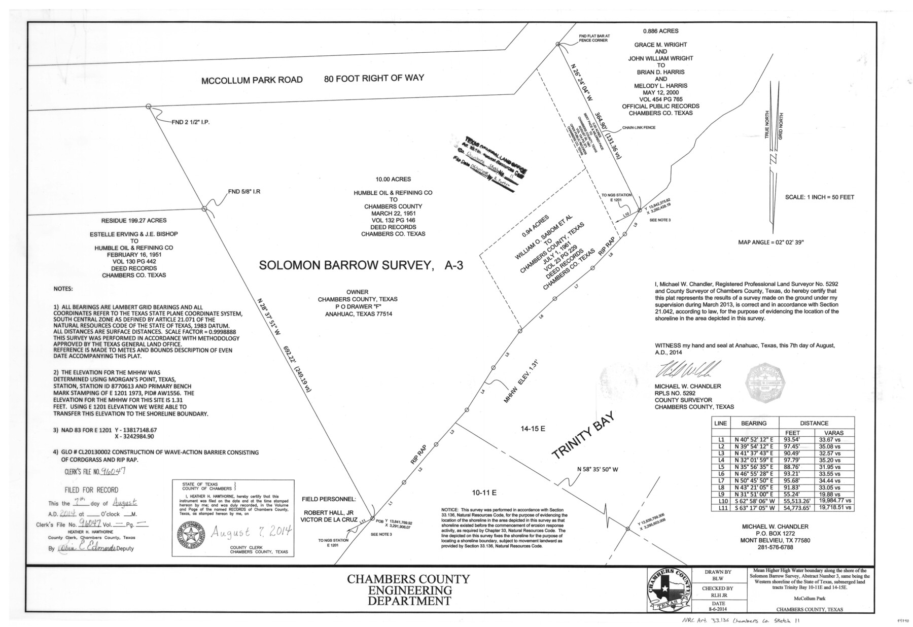
Mean higher high water boundary along the shore of the Solomon Barrow survey, abstract number 3, same being the western shoreline of the State of Texas, submerged land tracts Trinity Bay 10-11E and 14-15E, McCollum Park
-
Map/Doc
94740
-
Collection
General Map Collection
-
Object Dates
2014/8/7 (Creation Date)
2018/6/20 (File Date)
-
People and Organizations
Michael W. Chandler (Surveyor/Engineer)
-
Counties
Chambers
-
Subjects
Surveying CBS
-
Height x Width
24.0 x 36.0 inches
61.0 x 91.4 cm
-
Medium
multi-page, multi-format
-
Scale
1 inch = 50 feet
-
Comments
Project: McCollum Park Shoreline Protection Project No.: CL20130002 (GLO)
Part of: General Map Collection
North end of Brazos Island

Print $20.00
- Digital $50.00
North end of Brazos Island
Size 26.0 x 18.3 inches
Map/Doc 72915
Brazoria County NRC Article 33.136 Sketch 29

Print $24.00
Brazoria County NRC Article 33.136 Sketch 29
2025
Map/Doc 97474

Nautical Chart 885-SC Intracoastal Waterway - Ellender to Galveston Bay, Louisiana-Texas

Print $20.00
- Digital $50.00
Nautical Chart 885-SC Intracoastal Waterway - Ellender to Galveston Bay, Louisiana-Texas
1972
Size 15.9 x 26.8 inches
Map/Doc 75910
Real County Working Sketch 15

Print $20.00
- Digital $50.00
Real County Working Sketch 15
1940
Size 17.7 x 22.3 inches
Map/Doc 71907
Brewster County Working Sketch 92

Print $40.00
- Digital $50.00
Brewster County Working Sketch 92
1975
Size 61.9 x 39.4 inches
Map/Doc 67692
Brewster County Rolled Sketch 43A

Print $40.00
- Digital $50.00
Brewster County Rolled Sketch 43A
Size 39.5 x 65.6 inches
Map/Doc 8477
Duval County Rolled Sketch 30

Print $20.00
- Digital $50.00
Duval County Rolled Sketch 30
1947
Size 15.8 x 27.8 inches
Map/Doc 5747
Presidio County Working Sketch 130

Print $20.00
- Digital $50.00
Presidio County Working Sketch 130
1989
Size 22.1 x 43.1 inches
Map/Doc 71808
Archer County Boundary File 7

Print $10.00
- Digital $50.00
Archer County Boundary File 7
Size 8.2 x 5.2 inches
Map/Doc 50116
Culberson County Working Sketch 51

Print $40.00
- Digital $50.00
Culberson County Working Sketch 51
1972
Size 65.0 x 34.0 inches
Map/Doc 68505
Comal County Working Sketch 12

Print $20.00
- Digital $50.00
Comal County Working Sketch 12
1987
Size 31.1 x 29.6 inches
Map/Doc 68178
You may also like
Jackson County Sketch File 17

Print $20.00
- Digital $50.00
Jackson County Sketch File 17
1913
Size 19.4 x 19.1 inches
Map/Doc 11841
Jack County Rolled Sketch 2

Print $20.00
- Digital $50.00
Jack County Rolled Sketch 2
1972
Size 31.3 x 29.0 inches
Map/Doc 6332
Presidio County Rolled Sketch 131A

Print $3.00
- Digital $50.00
Presidio County Rolled Sketch 131A
Size 15.8 x 9.3 inches
Map/Doc 10708
Dallas County Boundary File 6g

Print $6.00
- Digital $50.00
Dallas County Boundary File 6g
Size 11.2 x 8.7 inches
Map/Doc 52275
Van Zandt County Sketch File 27

Print $4.00
- Digital $50.00
Van Zandt County Sketch File 27
1859
Size 13.1 x 8.3 inches
Map/Doc 39447
Tyler County Working Sketch 24

Print $20.00
- Digital $50.00
Tyler County Working Sketch 24
1989
Size 34.8 x 40.6 inches
Map/Doc 69494
Hudspeth County Rolled Sketch 26

Print $20.00
- Digital $50.00
Hudspeth County Rolled Sketch 26
1909
Size 19.3 x 18.0 inches
Map/Doc 6247
El Paso County Boundary File 22

Print $4.00
- Digital $50.00
El Paso County Boundary File 22
Size 13.6 x 8.6 inches
Map/Doc 53216
Sterling County

Print $40.00
- Digital $50.00
Sterling County
1926
Size 48.5 x 34.7 inches
Map/Doc 63048
[Surveys along Richland Creek]
![320, [Surveys along Richland Creek], General Map Collection](https://historictexasmaps.com/wmedia_w700/maps/320.tif.jpg)
Print $2.00
- Digital $50.00
[Surveys along Richland Creek]
Size 7.2 x 6.0 inches
Map/Doc 320
Goliad County Sketch File 5

Print $6.00
- Digital $50.00
Goliad County Sketch File 5
Size 15.9 x 10.2 inches
Map/Doc 24218
Webb County Rolled Sketch 67

Print $20.00
- Digital $50.00
Webb County Rolled Sketch 67
1927
Size 31.4 x 32.0 inches
Map/Doc 10130