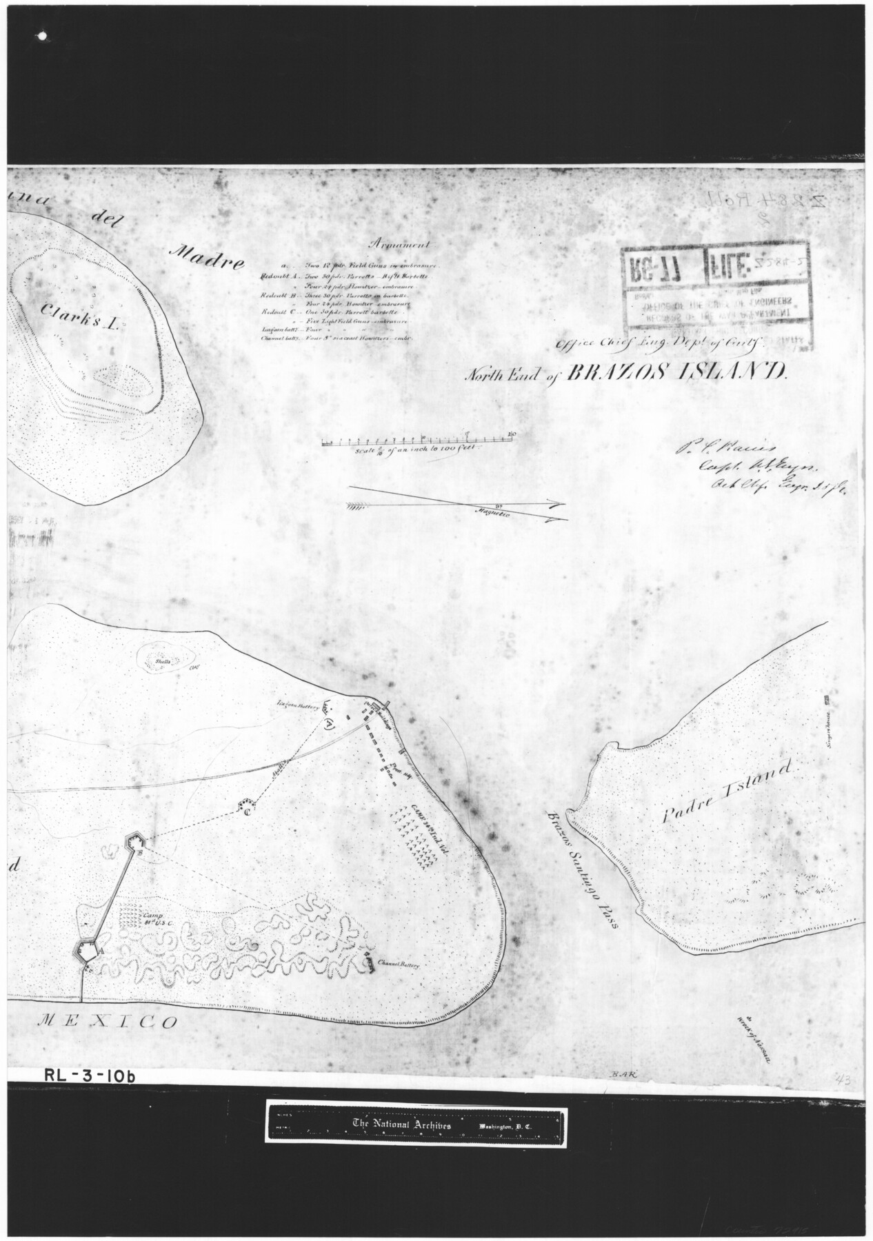
North end of Brazos Island
RL-3-10b
-
Map/Doc
72915
-
Collection
General Map Collection
-
People and Organizations
Office of Chief Engineer, Dept. of Gulf (Author)
-
Subjects
Gulf of Mexico
-
Height x Width
26.0 x 18.3 inches
66.0 x 46.5 cm
-
Comments
B/W photostat copy from National Archives in multiple pieces.
Part of: General Map Collection
Flight Mission No. BRA-16M, Frame 119, Jefferson County

Print $20.00
- Digital $50.00
Flight Mission No. BRA-16M, Frame 119, Jefferson County
1953
Size 18.6 x 22.5 inches
Map/Doc 85729
Foard County Working Sketch 4

Print $20.00
- Digital $50.00
Foard County Working Sketch 4
1934
Size 29.4 x 27.8 inches
Map/Doc 69194
Motley County Sketch File 30 (S)

Print $40.00
- Digital $50.00
Motley County Sketch File 30 (S)
1905
Size 16.1 x 17.1 inches
Map/Doc 42147
Gaines County Sketch File 9

Print $20.00
- Digital $50.00
Gaines County Sketch File 9
Size 34.1 x 17.1 inches
Map/Doc 11524
Dickens County

Print $20.00
- Digital $50.00
Dickens County
1880
Size 20.8 x 19.1 inches
Map/Doc 3485
Dimmit County Sketch File 55

Print $20.00
- Digital $50.00
Dimmit County Sketch File 55
1926
Size 23.1 x 15.7 inches
Map/Doc 11359
Brewster County Working Sketch 37

Print $20.00
- Digital $50.00
Brewster County Working Sketch 37
1944
Size 32.5 x 28.6 inches
Map/Doc 67571
Culberson County Working Sketch 30

Print $20.00
- Digital $50.00
Culberson County Working Sketch 30
1958
Size 29.3 x 30.2 inches
Map/Doc 68483
Archer County Boundary File 1

Print $26.00
- Digital $50.00
Archer County Boundary File 1
Size 14.2 x 8.8 inches
Map/Doc 50082
Copy of Surveyor's Field Book, Morris Browning - In Blocks 7, 5 & 4, I&GNRRCo., Hutchinson and Carson Counties, Texas

Print $2.00
- Digital $50.00
Copy of Surveyor's Field Book, Morris Browning - In Blocks 7, 5 & 4, I&GNRRCo., Hutchinson and Carson Counties, Texas
1888
Size 6.8 x 8.8 inches
Map/Doc 62274
Aransas Pass to Baffin Bay

Print $20.00
- Digital $50.00
Aransas Pass to Baffin Bay
1976
Size 41.9 x 35.3 inches
Map/Doc 73419
Hudspeth County Rolled Sketch 52

Print $20.00
- Digital $50.00
Hudspeth County Rolled Sketch 52
1975
Size 27.2 x 21.6 inches
Map/Doc 6257
You may also like
Edwards County Working Sketch 94

Print $40.00
- Digital $50.00
Edwards County Working Sketch 94
1968
Size 28.0 x 49.4 inches
Map/Doc 68970
Terry County Sketch File 20

Print $4.00
- Digital $50.00
Terry County Sketch File 20
2001
Size 11.1 x 8.8 inches
Map/Doc 76365
Sutton County Rolled Sketch 69

Print $20.00
- Digital $50.00
Sutton County Rolled Sketch 69
Size 39.7 x 36.6 inches
Map/Doc 9981
Carte Générale du Royaume de la Nouvelle Espagne depuis le Parallele de 16° jusqu'au Parallele de 38° (Latitude Nord) dressée sur des Observations Astronomiques et sur l'ensemble des Matériaux qui existoient à Mexico, au commencement de l'année 1804

Print $20.00
- Digital $50.00
Carte Générale du Royaume de la Nouvelle Espagne depuis le Parallele de 16° jusqu'au Parallele de 38° (Latitude Nord) dressée sur des Observations Astronomiques et sur l'ensemble des Matériaux qui existoient à Mexico, au commencement de l'année 1804
1809
Size 21.7 x 32.9 inches
Map/Doc 93781
Wilbarger County Working Sketch 2b

Print $20.00
- Digital $50.00
Wilbarger County Working Sketch 2b
1922
Size 19.8 x 20.0 inches
Map/Doc 72540
Stanton Acres, a Subdivision of Tracts 2 and 3, Block 1; and Tract 1, Block 2]
![91336, Stanton Acres, a Subdivision of Tracts 2 and 3, Block 1; and Tract 1, Block 2], Twichell Survey Records](https://historictexasmaps.com/wmedia_w700/maps/91336-1.tif.jpg)
Print $3.00
- Digital $50.00
Stanton Acres, a Subdivision of Tracts 2 and 3, Block 1; and Tract 1, Block 2]
Size 9.4 x 11.8 inches
Map/Doc 91336

Austin Empresario Colony. July 9, 1828

Print $20.00
Austin Empresario Colony. July 9, 1828
2020
Size 16.4 x 21.7 inches
Map/Doc 95982
Flight Mission No. BRA-7M, Frame 178, Jefferson County

Print $20.00
- Digital $50.00
Flight Mission No. BRA-7M, Frame 178, Jefferson County
1953
Size 18.6 x 22.4 inches
Map/Doc 85546
Bosque County Sketch File 28

Print $6.00
- Digital $50.00
Bosque County Sketch File 28
1888
Size 7.3 x 10.3 inches
Map/Doc 14813
Harris County Sketch File 56

Print $4.00
- Digital $50.00
Harris County Sketch File 56
1918
Size 8.2 x 12.8 inches
Map/Doc 25454
Crockett County Working Sketch 87

Print $20.00
- Digital $50.00
Crockett County Working Sketch 87
1976
Size 35.5 x 43.8 inches
Map/Doc 68420