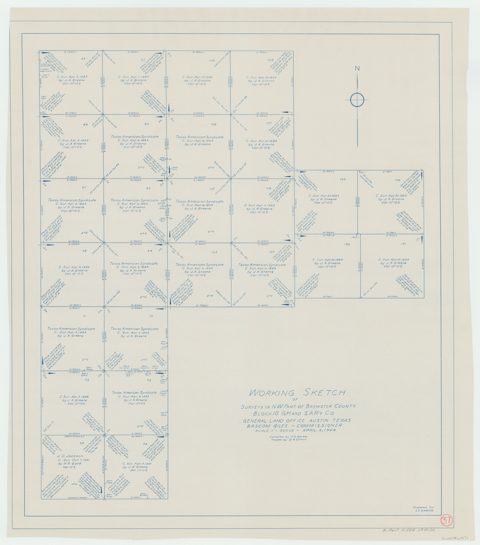
Brewster County Working Sketch 37
-
Map/Doc
67571
-
Collection
General Map Collection
-
Object Dates
4/4/1944 (Creation Date)
-
People and Organizations
F.H. Becker (Compiler)
D.R. Ellison (Tracer)
-
Counties
Brewster
-
Subjects
Surveying Working Sketch
-
Height x Width
32.5 x 28.6 inches
82.6 x 72.6 cm
-
Scale
1" = 500 varas
Part of: General Map Collection
McMullen County Working Sketch 60

Print $20.00
- Digital $50.00
McMullen County Working Sketch 60
1987
Size 23.0 x 32.6 inches
Map/Doc 70761
Coke County Working Sketch 15

Print $20.00
- Digital $50.00
Coke County Working Sketch 15
1948
Size 25.7 x 21.7 inches
Map/Doc 68052
Jackson County Sketch File 6

Print $4.00
- Digital $50.00
Jackson County Sketch File 6
1897
Size 13.1 x 8.9 inches
Map/Doc 27632
Flight Mission No. DCL-4C, Frame 4, Kenedy County

Print $20.00
- Digital $50.00
Flight Mission No. DCL-4C, Frame 4, Kenedy County
1943
Size 18.7 x 22.3 inches
Map/Doc 85805
Dallas County

Print $20.00
- Digital $50.00
Dallas County
1942
Size 45.1 x 37.1 inches
Map/Doc 77258
Kerr County Working Sketch 14

Print $20.00
- Digital $50.00
Kerr County Working Sketch 14
1952
Size 26.5 x 24.5 inches
Map/Doc 70045
Jefferson County Rolled Sketch 61B

Print $20.00
- Digital $50.00
Jefferson County Rolled Sketch 61B
1928
Size 27.3 x 40.3 inches
Map/Doc 6411
Kendall County Rolled Sketch 8

Print $20.00
- Digital $50.00
Kendall County Rolled Sketch 8
1994
Size 17.0 x 18.3 inches
Map/Doc 6461
Presidio County Working Sketch 117

Print $20.00
- Digital $50.00
Presidio County Working Sketch 117
1982
Size 14.7 x 15.9 inches
Map/Doc 71794
Travis County Sketch File 58

Print $14.00
- Digital $50.00
Travis County Sketch File 58
1948
Size 11.4 x 8.9 inches
Map/Doc 38406
Stonewall County Rolled Sketch 20

Print $40.00
- Digital $50.00
Stonewall County Rolled Sketch 20
1951
Size 30.1 x 55.4 inches
Map/Doc 63915
Cooke County Working Sketch 18

Print $20.00
- Digital $50.00
Cooke County Working Sketch 18
1952
Size 23.5 x 19.6 inches
Map/Doc 68255
You may also like
Flight Mission No. DQN-2K, Frame 47, Calhoun County

Print $20.00
- Digital $50.00
Flight Mission No. DQN-2K, Frame 47, Calhoun County
1953
Size 18.5 x 22.2 inches
Map/Doc 84252
General Highway Map Burnet County, Texas

Print $20.00
- Digital $50.00
General Highway Map Burnet County, Texas
1953
Size 25.8 x 18.7 inches
Map/Doc 92470
Brown County Sketch File 30

Print $27.00
- Digital $50.00
Brown County Sketch File 30
1924
Size 12.7 x 11.0 inches
Map/Doc 16631
Americae nova Tabula

Print $20.00
- Digital $50.00
Americae nova Tabula
1635
Size 18.4 x 24.3 inches
Map/Doc 93812

Upton County Rolled Sketch 55

Print $40.00
- Digital $50.00
Upton County Rolled Sketch 55
Size 192.5 x 25.4 inches
Map/Doc 10060
[Surveys in the vicinity of the Martina Olivares survey]
![90891, [Surveys in the vicinity of the Martina Olivares survey], Twichell Survey Records](https://historictexasmaps.com/wmedia_w700/maps/90891-1.tif.jpg)
Print $3.00
- Digital $50.00
[Surveys in the vicinity of the Martina Olivares survey]
1911
Size 10.3 x 16.9 inches
Map/Doc 90891
Tarrant County Working Sketch 17

Print $20.00
- Digital $50.00
Tarrant County Working Sketch 17
1983
Size 24.6 x 20.7 inches
Map/Doc 62434
Red River County

Print $20.00
- Digital $50.00
Red River County
1860
Size 23.0 x 20.8 inches
Map/Doc 3980
Map of McClennan County

Print $20.00
- Digital $50.00
Map of McClennan County
1871
Size 18.0 x 21.7 inches
Map/Doc 3862
Pecos County Rolled Sketch 61

Print $20.00
- Digital $50.00
Pecos County Rolled Sketch 61
1925
Size 26.5 x 25.5 inches
Map/Doc 7233
Flight Mission No. CUG-3P, Frame 165, Kleberg County

Print $20.00
- Digital $50.00
Flight Mission No. CUG-3P, Frame 165, Kleberg County
1956
Size 18.5 x 22.2 inches
Map/Doc 86285