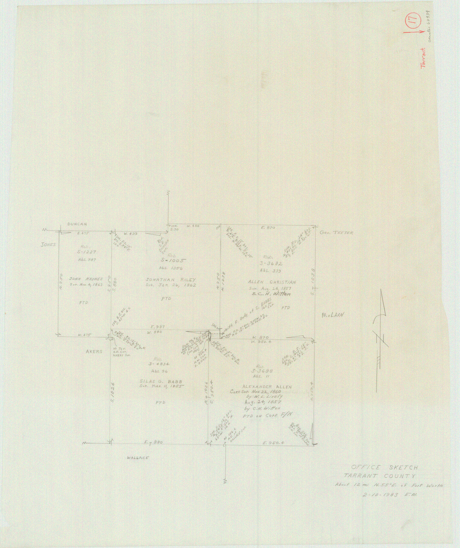
Tarrant County Working Sketch 17
-
Map/Doc
62434
-
Collection
General Map Collection
-
Object Dates
2/10/1983 (Creation Date)
-
People and Organizations
Elbert Menzel (Draftsman)
-
Counties
Tarrant
-
Subjects
Surveying Working Sketch
-
Height x Width
24.6 x 20.7 inches
62.5 x 52.6 cm
Part of: General Map Collection
Fractional Township No. 10 South Range No. 9 East of the Indian Meridian, Indian Territory

Print $20.00
- Digital $50.00
Fractional Township No. 10 South Range No. 9 East of the Indian Meridian, Indian Territory
1898
Size 19.3 x 24.4 inches
Map/Doc 75217
Jefferson County Rolled Sketch 25

Print $20.00
- Digital $50.00
Jefferson County Rolled Sketch 25
1939
Size 43.4 x 36.0 inches
Map/Doc 9290
Atascosa County Sketch File 17

Print $2.00
- Digital $50.00
Atascosa County Sketch File 17
Size 7.9 x 6.6 inches
Map/Doc 13783
Collingsworth County

Print $20.00
- Digital $50.00
Collingsworth County
1971
Size 42.7 x 35.8 inches
Map/Doc 95460
Galveston County Sketch File 35

Print $8.00
- Digital $50.00
Galveston County Sketch File 35
1934
Size 11.3 x 8.8 inches
Map/Doc 23419
Hamilton County Working Sketch 23

Print $20.00
- Digital $50.00
Hamilton County Working Sketch 23
1955
Size 23.5 x 31.2 inches
Map/Doc 63361
Austin County Rolled Sketch 4

Print $20.00
- Digital $50.00
Austin County Rolled Sketch 4
Size 30.8 x 44.8 inches
Map/Doc 8435
Sterling County Sketch File 11

Print $40.00
- Digital $50.00
Sterling County Sketch File 11
1929
Size 14.2 x 17.2 inches
Map/Doc 37148
Kerr County Boundary File 6

Print $8.00
- Digital $50.00
Kerr County Boundary File 6
Size 14.2 x 8.7 inches
Map/Doc 64822
Flight Mission No. CRK-8P, Frame 99, Refugio County

Print $20.00
- Digital $50.00
Flight Mission No. CRK-8P, Frame 99, Refugio County
1956
Size 18.3 x 22.1 inches
Map/Doc 86960
Duval County Working Sketch 44

Print $20.00
- Digital $50.00
Duval County Working Sketch 44
1977
Size 27.5 x 40.7 inches
Map/Doc 68768
Ochiltree County

Print $20.00
- Digital $50.00
Ochiltree County
1958
Size 44.4 x 35.5 inches
Map/Doc 95603
You may also like
Polk County Sketch File 4

Print $4.00
- Digital $50.00
Polk County Sketch File 4
1859
Size 10.2 x 8.0 inches
Map/Doc 34126
Red River County Sketch File 5

Print $4.00
- Digital $50.00
Red River County Sketch File 5
Size 7.9 x 4.8 inches
Map/Doc 35102
Flight Mission No. DIX-10P, Frame 69, Aransas County

Print $20.00
- Digital $50.00
Flight Mission No. DIX-10P, Frame 69, Aransas County
1956
Size 18.8 x 22.4 inches
Map/Doc 83930
Harris County Historic Topographic 21

Print $20.00
- Digital $50.00
Harris County Historic Topographic 21
1915
Size 29.2 x 22.5 inches
Map/Doc 65832
Kerr County Sketch File 13

Print $11.00
- Digital $50.00
Kerr County Sketch File 13
1927
Size 16.9 x 8.1 inches
Map/Doc 28883
Hardin County Sketch File 28

Print $4.00
- Digital $50.00
Hardin County Sketch File 28
Size 5.9 x 5.8 inches
Map/Doc 25153
Flight Mission No. DAG-24K, Frame 37, Matagorda County

Print $20.00
- Digital $50.00
Flight Mission No. DAG-24K, Frame 37, Matagorda County
1953
Size 18.5 x 22.2 inches
Map/Doc 86524
The Republic County of Jackson. December 24, 1844

Print $20.00
The Republic County of Jackson. December 24, 1844
2020
Size 15.6 x 21.8 inches
Map/Doc 96191
Port of Galveston

Print $40.00
- Digital $50.00
Port of Galveston
1978
Size 20.0 x 68.9 inches
Map/Doc 83336
General Highway Map, Sterling County, Texas

Print $20.00
General Highway Map, Sterling County, Texas
1940
Size 24.9 x 18.4 inches
Map/Doc 79248
Colorado County Working Sketch 1

Print $20.00
- Digital $50.00
Colorado County Working Sketch 1
1897
Size 16.2 x 21.3 inches
Map/Doc 68101
Flight Mission No. DIX-10P, Frame 149, Aransas County

Print $20.00
- Digital $50.00
Flight Mission No. DIX-10P, Frame 149, Aransas County
1956
Size 18.6 x 22.3 inches
Map/Doc 83951