Austin County Rolled Sketch 4
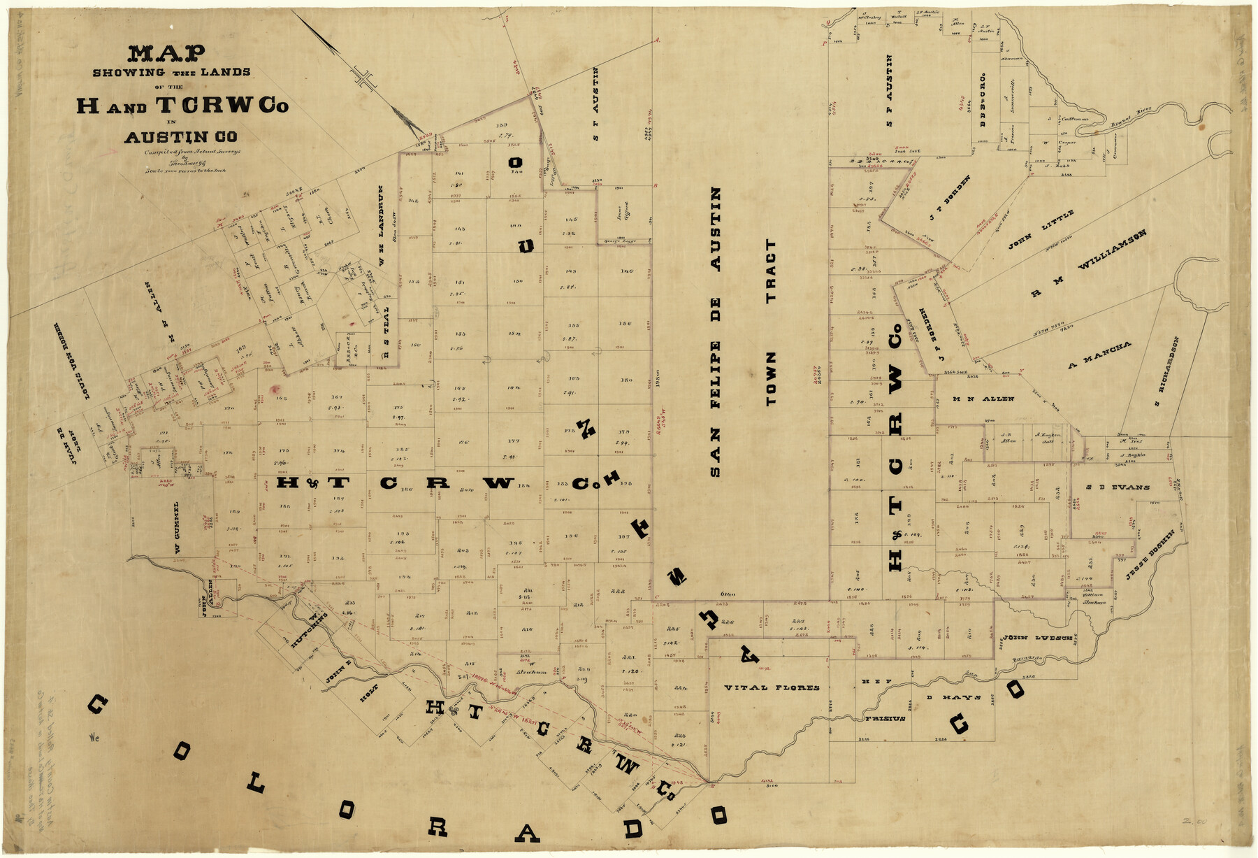
Map showing the lands of the H. and T. C. RW. Co. In Austin Co.
-
Map/Doc
8435
-
Collection
General Map Collection
-
People and Organizations
Theo Kosse (Compiler)
-
Counties
Austin
-
Subjects
Surveying Rolled Sketch
-
Height x Width
30.8 x 44.8 inches
78.2 x 113.8 cm
-
Medium
linen, manuscript
-
Scale
1" = 1000 varas
Part of: General Map Collection
Red River County Working Sketch 61

Print $20.00
- Digital $50.00
Red River County Working Sketch 61
1973
Size 37.8 x 38.5 inches
Map/Doc 72044
Real County Working Sketch 39

Print $20.00
- Digital $50.00
Real County Working Sketch 39
1951
Size 33.5 x 36.6 inches
Map/Doc 71931
Flight Mission No. DIX-10P, Frame 183, Aransas County

Print $20.00
- Digital $50.00
Flight Mission No. DIX-10P, Frame 183, Aransas County
1956
Size 18.4 x 22.1 inches
Map/Doc 83973
Flight Mission No. CUG-1P, Frame 86, Kleberg County

Print $20.00
- Digital $50.00
Flight Mission No. CUG-1P, Frame 86, Kleberg County
1956
Size 18.5 x 22.2 inches
Map/Doc 86151
Austin Street Map & Guide

Digital $50.00
Austin Street Map & Guide
Size 35.4 x 23.1 inches
Map/Doc 94435
North Sulphur River, Ben Franklin Sheet

Print $20.00
- Digital $50.00
North Sulphur River, Ben Franklin Sheet
1928
Size 14.2 x 30.0 inches
Map/Doc 78324
Flight Mission No. DQN-5K, Frame 81, Calhoun County

Print $20.00
- Digital $50.00
Flight Mission No. DQN-5K, Frame 81, Calhoun County
1953
Size 18.5 x 22.2 inches
Map/Doc 84414

Map of the Property traversed by the Trinity & Sabine Railroad from Fortieth Mile to Ogden, Texas

Print $40.00
- Digital $50.00
Map of the Property traversed by the Trinity & Sabine Railroad from Fortieth Mile to Ogden, Texas
1882
Size 39.5 x 93.2 inches
Map/Doc 64046
Marion County Working Sketch 8

Print $20.00
- Digital $50.00
Marion County Working Sketch 8
1935
Size 31.9 x 36.6 inches
Map/Doc 70783
Hood County Sketch File 8

Print $4.00
- Digital $50.00
Hood County Sketch File 8
Size 7.8 x 8.0 inches
Map/Doc 26584
Coke County Rolled Sketch 31

Print $20.00
- Digital $50.00
Coke County Rolled Sketch 31
1982
Size 13.3 x 30.2 inches
Map/Doc 5526
You may also like
La Salle County Sketch File 45

Print $40.00
- Digital $50.00
La Salle County Sketch File 45
1939
Size 16.9 x 14.2 inches
Map/Doc 29601
Cottle County Sketch File 10

Print $20.00
- Digital $50.00
Cottle County Sketch File 10
Size 15.7 x 23.1 inches
Map/Doc 11193
Brewster County Working Sketch 72

Print $20.00
- Digital $50.00
Brewster County Working Sketch 72
1965
Size 20.7 x 24.6 inches
Map/Doc 67672
Flight Mission No. CUG-1P, Frame 161, Kleberg County

Print $20.00
- Digital $50.00
Flight Mission No. CUG-1P, Frame 161, Kleberg County
1956
Size 18.5 x 22.3 inches
Map/Doc 86168
Dimmit County Rolled Sketch 18

Print $20.00
- Digital $50.00
Dimmit County Rolled Sketch 18
1978
Size 20.2 x 26.0 inches
Map/Doc 5725
Reagan County Rolled Sketch 20

Print $20.00
- Digital $50.00
Reagan County Rolled Sketch 20
1948
Size 45.8 x 45.0 inches
Map/Doc 9814
19th Congressional District of Texas

Print $20.00
- Digital $50.00
19th Congressional District of Texas
Size 33.1 x 28.9 inches
Map/Doc 92610
Bexar County State Real Property Sketch 2

Print $40.00
- Digital $50.00
Bexar County State Real Property Sketch 2
1997
Size 25.6 x 38.7 inches
Map/Doc 61701
Garza County Working Sketch 9

Print $20.00
- Digital $50.00
Garza County Working Sketch 9
1952
Size 15.7 x 18.0 inches
Map/Doc 63156
Dickens County Sketch File D1

Print $50.00
- Digital $50.00
Dickens County Sketch File D1
Size 13.0 x 19.4 inches
Map/Doc 20833
El Paso County Rolled Sketch Z57

Print $20.00
- Digital $50.00
El Paso County Rolled Sketch Z57
1915
Size 36.5 x 47.2 inches
Map/Doc 8871
Hill County Sketch File 22

Print $8.00
- Digital $50.00
Hill County Sketch File 22
1860
Size 7.7 x 8.2 inches
Map/Doc 26505