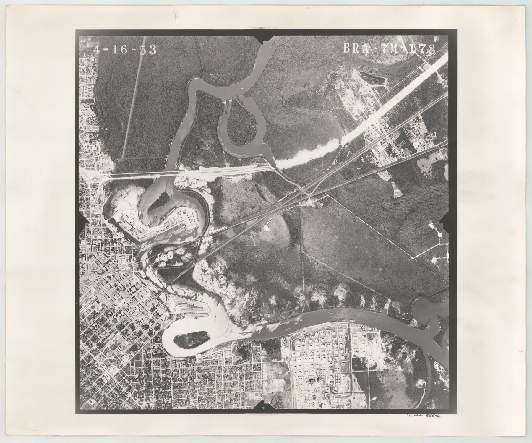
Flight Mission No. BRA-7M, Frame 178, Jefferson County
BRA-7M-178
-
Map/Doc
85546
-
Collection
General Map Collection
-
Object Dates
1953/4/16 (Creation Date)
-
People and Organizations
U. S. Department of Agriculture (Publisher)
-
Counties
Jefferson
-
Subjects
Aerial Photograph
-
Height x Width
18.6 x 22.4 inches
47.2 x 56.9 cm
-
Comments
Flown by Jack Ammann Photogrammetric Engineers of San Antonio, Texas.
Part of: General Map Collection
Brazoria County NRC Article 33.136 Sketch 7

Print $21.00
- Digital $50.00
Brazoria County NRC Article 33.136 Sketch 7
2004
Size 23.7 x 33.3 inches
Map/Doc 82907
Frio County Working Sketch 5

Print $20.00
- Digital $50.00
Frio County Working Sketch 5
1936
Size 33.9 x 23.0 inches
Map/Doc 69279

Wise County Sketch File 11

Print $4.00
- Digital $50.00
Wise County Sketch File 11
1860
Size 12.8 x 8.0 inches
Map/Doc 40544
Orange County NRC Article 33.136 Sketch 4

Print $24.00
- Digital $50.00
Orange County NRC Article 33.136 Sketch 4
2011
Size 22.6 x 31.2 inches
Map/Doc 93271
![94181, San Antonio [Recto], General Map Collection](https://historictexasmaps.com/wmedia_w700/maps/94181.tif.jpg)
Galveston County Sketch File 67

Print $4.00
- Digital $50.00
Galveston County Sketch File 67
1988
Size 11.3 x 8.7 inches
Map/Doc 23782
Jeff Davis County Rolled Sketch 37

Print $20.00
- Digital $50.00
Jeff Davis County Rolled Sketch 37
1992
Size 29.3 x 35.5 inches
Map/Doc 6380
Montgomery County Working Sketch 42

Print $20.00
- Digital $50.00
Montgomery County Working Sketch 42
1956
Size 21.3 x 32.8 inches
Map/Doc 71149
Montgomery County Sketch File 17

Print $42.00
- Digital $50.00
Montgomery County Sketch File 17
1912
Size 8.6 x 7.8 inches
Map/Doc 31832
Travis County Working Sketch 38

Print $20.00
- Digital $50.00
Travis County Working Sketch 38
1974
Size 17.5 x 34.8 inches
Map/Doc 69422
Irion County Boundary File 4a

Print $40.00
- Digital $50.00
Irion County Boundary File 4a
Size 8.6 x 38.7 inches
Map/Doc 55361
You may also like
Chambers County Rolled Sketch 34

Print $40.00
- Digital $50.00
Chambers County Rolled Sketch 34
1956
Size 50.0 x 85.8 inches
Map/Doc 73571
General Highway Map, Nueces County, Texas

Print $20.00
General Highway Map, Nueces County, Texas
1961
Size 24.9 x 18.4 inches
Map/Doc 79615
Wise County Rolled Sketch 6

Print $20.00
- Digital $50.00
Wise County Rolled Sketch 6
2000
Size 32.0 x 43.1 inches
Map/Doc 8280
Upshur County Boundary File 1

Print $30.00
- Digital $50.00
Upshur County Boundary File 1
Size 9.4 x 8.6 inches
Map/Doc 59500
Schleicher County Sketch File 25

Print $20.00
- Digital $50.00
Schleicher County Sketch File 25
1937
Size 24.1 x 17.5 inches
Map/Doc 12304
Flight Mission No. CRC-3R, Frame 18, Chambers County

Print $20.00
- Digital $50.00
Flight Mission No. CRC-3R, Frame 18, Chambers County
1956
Size 18.7 x 22.4 inches
Map/Doc 84792
Galveston County NRC Article 33.136 Sketch 18

Print $66.00
- Digital $50.00
Galveston County NRC Article 33.136 Sketch 18
2003
Size 22.4 x 33.9 inches
Map/Doc 78545
Coast Chart No. 210 Aransas Pass and Corpus Christi Bay with the coast to latitude 27° 12' Texas

Print $20.00
- Digital $50.00
Coast Chart No. 210 Aransas Pass and Corpus Christi Bay with the coast to latitude 27° 12' Texas
1913
Size 27.0 x 18.2 inches
Map/Doc 72800
Coleman County Sketch File 40

Print $28.00
- Digital $50.00
Coleman County Sketch File 40
Size 14.3 x 8.9 inches
Map/Doc 18744
Dallas County Boundary File 6d

Print $104.00
- Digital $50.00
Dallas County Boundary File 6d
Size 14.2 x 8.6 inches
Map/Doc 52229
Jackson County Sketch File 5

Print $4.00
- Digital $50.00
Jackson County Sketch File 5
1876
Size 12.7 x 8.2 inches
Map/Doc 27628
Lynn County Sketch File 18

Print $4.00
- Digital $50.00
Lynn County Sketch File 18
1940
Size 11.2 x 8.8 inches
Map/Doc 30514