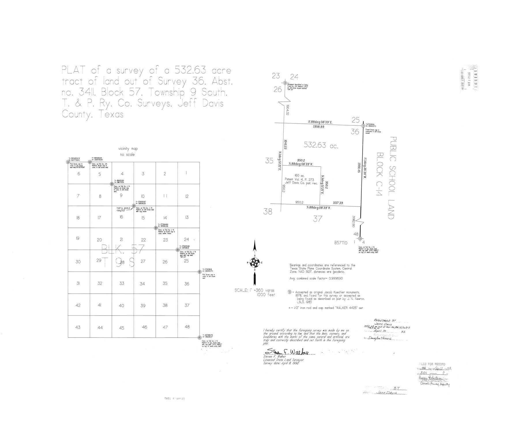
Jeff Davis County Rolled Sketch 37
Plat of a survey of a 532.63 acre tract of land out of survey 36, abst. no. 3411, Block 57, Township 9 South, T. & P. Ry. Co. surveys
-
Map/Doc
6380
-
Collection
General Map Collection
-
Object Dates
1992/4/8 (Creation Date)
1992/4/15 (File Date)
-
People and Organizations
Steven F. Walker (Surveyor/Engineer)
-
Counties
Jeff Davis
-
Subjects
Surveying Rolled Sketch
-
Height x Width
29.3 x 35.5 inches
74.4 x 90.2 cm
-
Medium
mylar, print
-
Scale
1" = 360 varas
Part of: General Map Collection
Webb County Rolled Sketch 4

Print $20.00
- Digital $50.00
Webb County Rolled Sketch 4
Size 32.8 x 26.3 inches
Map/Doc 8171
Sulphur River, Terry Lake Sheet

Print $20.00
- Digital $50.00
Sulphur River, Terry Lake Sheet
1919
Size 28.6 x 30.9 inches
Map/Doc 65161
Trinity County Sketch File 32

Print $20.00
- Digital $50.00
Trinity County Sketch File 32
1894
Size 22.4 x 18.3 inches
Map/Doc 12490
Bee County Sketch File 3a

Print $8.00
- Digital $50.00
Bee County Sketch File 3a
1875
Size 12.7 x 8.2 inches
Map/Doc 14264
Map of the country adjacent to the left bank of the Rio Grande below Matamoros

Print $20.00
- Digital $50.00
Map of the country adjacent to the left bank of the Rio Grande below Matamoros
1847
Size 18.3 x 27.5 inches
Map/Doc 72870
San Patricio County Rolled Sketch 20A

Print $20.00
- Digital $50.00
San Patricio County Rolled Sketch 20A
Size 25.9 x 30.3 inches
Map/Doc 7579
El Paso County State Real Property Sketch 2

Print $20.00
- Digital $50.00
El Paso County State Real Property Sketch 2
2007
Size 24.4 x 36.2 inches
Map/Doc 88671
Panola County Rolled Sketch 3

Print $1246.00
- Digital $50.00
Panola County Rolled Sketch 3
1949
Size 10.3 x 15.2 inches
Map/Doc 47978
Brooks County Rolled Sketch 27

Print $20.00
- Digital $50.00
Brooks County Rolled Sketch 27
1945
Size 44.5 x 42.9 inches
Map/Doc 8540
Callahan County Sketch File 11

Print $64.00
- Digital $50.00
Callahan County Sketch File 11
Size 11.4 x 8.4 inches
Map/Doc 35887
Wheeler County Working Sketch 3

Print $40.00
- Digital $50.00
Wheeler County Working Sketch 3
1972
Size 73.8 x 43.7 inches
Map/Doc 72492
Topographical Map of the Rio Grande, Sheet No. 28

Print $20.00
- Digital $50.00
Topographical Map of the Rio Grande, Sheet No. 28
1912
Map/Doc 89552
You may also like


Archer County Rolled Sketch B2

Print $20.00
- Digital $50.00
Archer County Rolled Sketch B2
1891
Size 36.7 x 30.7 inches
Map/Doc 5105
Texas Coast Showing Points of Occupation of Expedition Under Maj. Gen. N.P. Banks, Novr. 1863

Print $20.00
Texas Coast Showing Points of Occupation of Expedition Under Maj. Gen. N.P. Banks, Novr. 1863
1863
Size 16.0 x 17.1 inches
Map/Doc 88593
Loving County Rolled Sketch 5

Print $40.00
- Digital $50.00
Loving County Rolled Sketch 5
1952
Size 146.0 x 14.2 inches
Map/Doc 9467
Aransas County Working Sketch 12

Print $20.00
- Digital $50.00
Aransas County Working Sketch 12
1950
Size 18.3 x 23.8 inches
Map/Doc 67179
New Map of the Mining Regions of Idaho and Montana showing the geographical positions of the Blackfoot, Owyhee & South Boise Mines and the various routes thereto

Print $20.00
- Digital $50.00
New Map of the Mining Regions of Idaho and Montana showing the geographical positions of the Blackfoot, Owyhee & South Boise Mines and the various routes thereto
Size 21.9 x 29.4 inches
Map/Doc 93991
Flight Mission No. BRA-7M, Frame 204, Jefferson County

Print $20.00
- Digital $50.00
Flight Mission No. BRA-7M, Frame 204, Jefferson County
1953
Size 18.6 x 22.3 inches
Map/Doc 85572
Kleberg County Rolled Sketch 10-6

Print $20.00
- Digital $50.00
Kleberg County Rolled Sketch 10-6
1951
Size 38.0 x 39.1 inches
Map/Doc 9399

Crockett County Working Sketch 19

Print $20.00
- Digital $50.00
Crockett County Working Sketch 19
1919
Size 23.7 x 17.7 inches
Map/Doc 68352
Presidio County Boundary File 2

Print $8.00
- Digital $50.00
Presidio County Boundary File 2
Size 14.0 x 8.6 inches
Map/Doc 58054