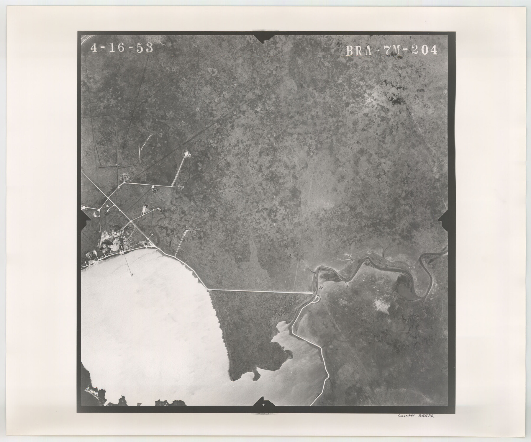
Flight Mission No. BRA-7M, Frame 204, Jefferson County
[Aerial Photo, Jefferson County, frame BRA-7M-204]
-
Map/Doc
85572
-
Collection
General Map Collection
-
Object Dates
1953/4/16 (Creation Date)
-
People and Organizations
U. S. Department of Agriculture (Publisher)
-
Counties
Jefferson
-
Subjects
Aerial Photograph
-
Height x Width
18.6 x 22.3 inches
47.2 x 56.6 cm
-
Comments
Flown by Jack Ammann Photogrammetric Engineers of San Antonio, Texas.
Part of: General Map Collection
Austin County Boundary File 4

Print $10.00
- Digital $50.00
Austin County Boundary File 4
Size 14.1 x 8.6 inches
Map/Doc 50244
Hudspeth County Sketch File 40

Print $8.00
- Digital $50.00
Hudspeth County Sketch File 40
1944
Size 11.2 x 8.6 inches
Map/Doc 27012
Flight Mission No. DQO-3K, Frame 19, Galveston County

Print $20.00
- Digital $50.00
Flight Mission No. DQO-3K, Frame 19, Galveston County
1952
Size 18.7 x 22.5 inches
Map/Doc 85060
Jeff Davis County Working Sketch 21

Print $20.00
- Digital $50.00
Jeff Davis County Working Sketch 21
1957
Size 25.2 x 44.0 inches
Map/Doc 66516
Flight Mission No. BQR-7K, Frame 30, Brazoria County

Print $20.00
- Digital $50.00
Flight Mission No. BQR-7K, Frame 30, Brazoria County
1952
Size 18.6 x 22.3 inches
Map/Doc 84028
Flight Mission No. DCL-4C, Frame 95, Kenedy County

Print $20.00
- Digital $50.00
Flight Mission No. DCL-4C, Frame 95, Kenedy County
1943
Size 18.7 x 22.3 inches
Map/Doc 85816
Flight Mission No. DCL-7C, Frame 133, Kenedy County

Print $20.00
- Digital $50.00
Flight Mission No. DCL-7C, Frame 133, Kenedy County
1943
Size 15.4 x 15.2 inches
Map/Doc 86090
Township 1 North Range 11 West, North Western District, Louisiana

Print $3.00
- Digital $50.00
Township 1 North Range 11 West, North Western District, Louisiana
1884
Size 17.5 x 21.5 inches
Map/Doc 65892
La Salle County Rolled Sketch 10

Print $40.00
- Digital $50.00
La Salle County Rolled Sketch 10
1945
Size 48.1 x 33.5 inches
Map/Doc 6573
Kendall County Boundary File 3a

Print $8.00
- Digital $50.00
Kendall County Boundary File 3a
Size 11.2 x 8.9 inches
Map/Doc 55765
Pecos County Rolled Sketch 127

Print $20.00
- Digital $50.00
Pecos County Rolled Sketch 127
Size 20.7 x 23.9 inches
Map/Doc 7267
Fisher County Sketch File 6

Print $6.00
- Digital $50.00
Fisher County Sketch File 6
Size 9.7 x 15.9 inches
Map/Doc 22563
You may also like
Matagorda County NRC Article 33.136 Location Key Sheet

Print $20.00
- Digital $50.00
Matagorda County NRC Article 33.136 Location Key Sheet
1973
Size 27.0 x 23.0 inches
Map/Doc 88833
Dickens County Sketch File 14

Print $20.00
- Digital $50.00
Dickens County Sketch File 14
Size 19.6 x 16.6 inches
Map/Doc 11320
Rio Grande, La Puerta Sheet

Print $20.00
- Digital $50.00
Rio Grande, La Puerta Sheet
1931
Size 29.7 x 43.4 inches
Map/Doc 65106
Galveston County Sketch File 35

Print $8.00
- Digital $50.00
Galveston County Sketch File 35
1934
Size 11.3 x 8.8 inches
Map/Doc 23419
Guadalupe County

Print $20.00
- Digital $50.00
Guadalupe County
1854
Size 25.0 x 21.1 inches
Map/Doc 3609
Edwards County Rolled Sketch 24

Print $20.00
- Digital $50.00
Edwards County Rolled Sketch 24
1953
Size 29.9 x 38.0 inches
Map/Doc 5810
Newton County Rolled Sketch 8

Print $20.00
- Digital $50.00
Newton County Rolled Sketch 8
1945
Size 21.5 x 28.7 inches
Map/Doc 6844
[Brooks & Burleson Block 4, Hartley County]
![5037, [Brooks & Burleson Block 4, Hartley County], Maddox Collection](https://historictexasmaps.com/wmedia_w700/maps/5037.tif.jpg)
Print $3.00
- Digital $50.00
[Brooks & Burleson Block 4, Hartley County]
Size 10.3 x 9.5 inches
Map/Doc 5037
Navarro County Sketch File 20

Print $14.00
- Digital $50.00
Navarro County Sketch File 20
1967
Size 14.3 x 8.8 inches
Map/Doc 32343
Hansford County School Land

Print $20.00
- Digital $50.00
Hansford County School Land
1892
Size 33.3 x 20.7 inches
Map/Doc 92512
Sterling County Rolled Sketch 17

Print $40.00
- Digital $50.00
Sterling County Rolled Sketch 17
Size 61.0 x 48.4 inches
Map/Doc 9949
Ward County Sketch File 2

Print $40.00
- Digital $50.00
Ward County Sketch File 2
Size 25.0 x 62.7 inches
Map/Doc 10426