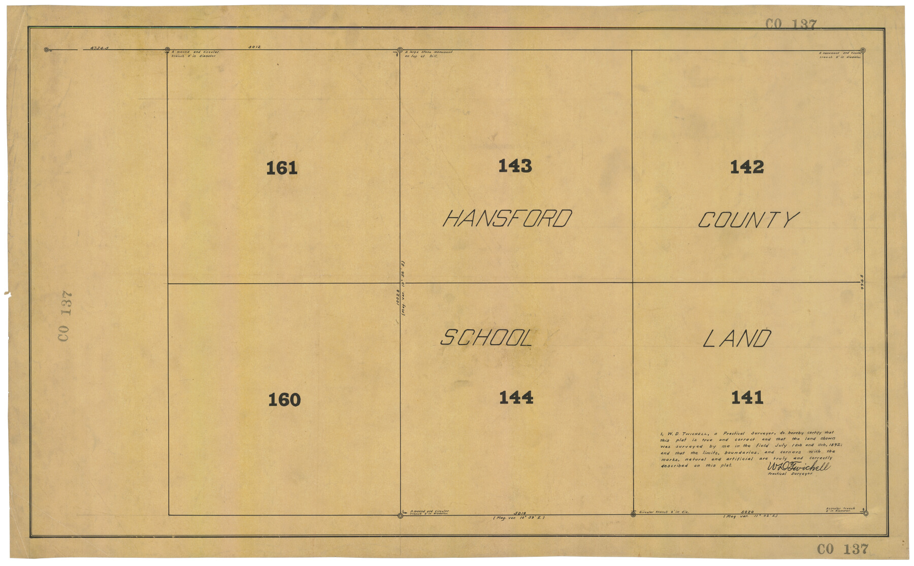
Hansford County School Land
CO137
-
Map/Doc
92512
-
Collection
Twichell Survey Records
-
Object Dates
7/11/1892 (Creation Date)
-
People and Organizations
W.D. Twichell (Surveyor/Engineer)
-
Counties
Cochran
-
Height x Width
33.3 x 20.7 inches
84.6 x 52.6 cm
Part of: Twichell Survey Records
Subdivision of the C.C. Slaughter Block No. 1, League 101 & part of League 102, Jeff Davis Co. School Land, part of League 100, Brewster Co. School Land and League 118 & part of Leagues 117 & 119, Knox Co. School Land

Print $20.00
- Digital $50.00
Subdivision of the C.C. Slaughter Block No. 1, League 101 & part of League 102, Jeff Davis Co. School Land, part of League 100, Brewster Co. School Land and League 118 & part of Leagues 117 & 119, Knox Co. School Land
1926
Size 18.8 x 19.4 inches
Map/Doc 90459
John H. Wills' Official Map of Amarillo, Potter Counter, Texas

Print $40.00
- Digital $50.00
John H. Wills' Official Map of Amarillo, Potter Counter, Texas
1909
Size 48.9 x 45.4 inches
Map/Doc 93118
Map of C. C. Slaughter Cattle Co.'s Ranch, Cochran-Hockley Counties, Texas

Print $20.00
- Digital $50.00
Map of C. C. Slaughter Cattle Co.'s Ranch, Cochran-Hockley Counties, Texas
Size 27.4 x 20.3 inches
Map/Doc 90439
[Blocks 47, Z, XO2, M18, M23, M25, and H]
![91186, [Blocks 47, Z, XO2, M18, M23, M25, and H], Twichell Survey Records](https://historictexasmaps.com/wmedia_w700/maps/91186-1.tif.jpg)
Print $20.00
- Digital $50.00
[Blocks 47, Z, XO2, M18, M23, M25, and H]
Size 30.1 x 23.5 inches
Map/Doc 91186
[Blocks W and Z with tie lines]
![90451, [Blocks W and Z with tie lines], Twichell Survey Records](https://historictexasmaps.com/wmedia_w700/maps/90451-1.tif.jpg)
Print $20.00
- Digital $50.00
[Blocks W and Z with tie lines]
1949
Size 14.4 x 14.2 inches
Map/Doc 90451
[Sketch showing Blocks 2B, 3B, 3T, IT and 2]
![91843, [Sketch showing Blocks 2B, 3B, 3T, IT and 2], Twichell Survey Records](https://historictexasmaps.com/wmedia_w700/maps/91843-1.tif.jpg)
Print $20.00
- Digital $50.00
[Sketch showing Blocks 2B, 3B, 3T, IT and 2]
1918
Size 32.9 x 30.1 inches
Map/Doc 91843
[Sketch of Berry Doolittle, C. B. Emmons. R. D. Price and other surveys]
![90213, [Sketch of Berry Doolittle, C. B. Emmons. R. D. Price and other surveys], Twichell Survey Records](https://historictexasmaps.com/wmedia_w700/maps/90213-1.tif.jpg)
Print $20.00
- Digital $50.00
[Sketch of Berry Doolittle, C. B. Emmons. R. D. Price and other surveys]
Size 25.8 x 19.7 inches
Map/Doc 90213
[Letter from T. F. Pinckney to W. D. Twichell accompanying sketch showing Blocks 14, 341, and G5]
![93110, [Letter from T. F. Pinckney to W. D. Twichell accompanying sketch showing Blocks 14, 341, and G5], Twichell Survey Records](https://historictexasmaps.com/wmedia_w700/maps/93110-1.tif.jpg)
Print $2.00
- Digital $50.00
[Letter from T. F. Pinckney to W. D. Twichell accompanying sketch showing Blocks 14, 341, and G5]
1911
Size 8.0 x 9.5 inches
Map/Doc 93110
[Blocks O, H, B, S, RG, and 11]
![91333, [Blocks O, H, B, S, RG, and 11], Twichell Survey Records](https://historictexasmaps.com/wmedia_w700/maps/91333-1.tif.jpg)
Print $20.00
- Digital $50.00
[Blocks O, H, B, S, RG, and 11]
1921
Size 24.9 x 15.3 inches
Map/Doc 91333
[B. S. & F. Blocks 1 and 6, A. B. & M. Block 2 and surrounding surveys and blocks]
![91785, [B. S. & F. Blocks 1 and 6, A. B. & M. Block 2 and surrounding surveys and blocks], Twichell Survey Records](https://historictexasmaps.com/wmedia_w700/maps/91785-1.tif.jpg)
Print $20.00
- Digital $50.00
[B. S. & F. Blocks 1 and 6, A. B. & M. Block 2 and surrounding surveys and blocks]
Size 22.6 x 33.8 inches
Map/Doc 91785
Thornton, Texas

Print $20.00
- Digital $50.00
Thornton, Texas
1922
Size 30.0 x 32.6 inches
Map/Doc 92143
James Heights, an addition to the City of Lubbock - tracts 4, 5, 6, 7, 8, 9, 10, 11, 12, 13 in Block 7, and tracts 4, 5, 6, 7, 8, 9, 10, 11, 12, 13 in Block 8 of the Clutter Addition

Print $3.00
- Digital $50.00
James Heights, an addition to the City of Lubbock - tracts 4, 5, 6, 7, 8, 9, 10, 11, 12, 13 in Block 7, and tracts 4, 5, 6, 7, 8, 9, 10, 11, 12, 13 in Block 8 of the Clutter Addition
1949
Size 10.1 x 11.4 inches
Map/Doc 92704
You may also like
General Highway Map. Detail of Cities and Towns in Lubbock County, Texas [Lubbock and vicinity]
![79579, General Highway Map. Detail of Cities and Towns in Lubbock County, Texas [Lubbock and vicinity], Texas State Library and Archives](https://historictexasmaps.com/wmedia_w700/maps/79579.tif.jpg)
Print $20.00
General Highway Map. Detail of Cities and Towns in Lubbock County, Texas [Lubbock and vicinity]
1961
Size 18.2 x 24.7 inches
Map/Doc 79579
Jeff Davis County Sketch File 28

Print $30.00
- Digital $50.00
Jeff Davis County Sketch File 28
1916
Size 7.2 x 8.7 inches
Map/Doc 28003
Kimble County Working Sketch 19

Print $20.00
- Digital $50.00
Kimble County Working Sketch 19
1926
Size 38.7 x 34.8 inches
Map/Doc 70087
Presidio County Working Sketch 49

Print $20.00
- Digital $50.00
Presidio County Working Sketch 49
1951
Size 34.5 x 47.0 inches
Map/Doc 71726
Reagan County Working Sketch 28

Print $40.00
- Digital $50.00
Reagan County Working Sketch 28
1963
Size 55.7 x 42.4 inches
Map/Doc 71870
Gaines County Rolled Sketch 30

Print $20.00
- Digital $50.00
Gaines County Rolled Sketch 30
1962
Size 19.4 x 26.3 inches
Map/Doc 5943
Galveston Entrance, Texas From a Trigonometrical Survey Under the direction of A.D. Bache Superintendent of the Survey of the Coast of the United States

Print $20.00
- Digital $50.00
Galveston Entrance, Texas From a Trigonometrical Survey Under the direction of A.D. Bache Superintendent of the Survey of the Coast of the United States
1853
Size 15.9 x 19.3 inches
Map/Doc 93998
Brewster County Working Sketch 53

Print $20.00
- Digital $50.00
Brewster County Working Sketch 53
1951
Size 32.1 x 16.5 inches
Map/Doc 67587
La Salle County Rolled Sketch 34

Print $20.00
- Digital $50.00
La Salle County Rolled Sketch 34
2019
Size 22.3 x 35.5 inches
Map/Doc 95702
General Highway Map, Walker County, Texas

Print $20.00
General Highway Map, Walker County, Texas
1961
Size 24.7 x 18.1 inches
Map/Doc 79698
Sutton County Sketch File 18

Print $94.00
- Digital $50.00
Sutton County Sketch File 18
1893
Size 12.9 x 8.3 inches
Map/Doc 37410
Wichita County Sketch File 9

Print $4.00
- Digital $50.00
Wichita County Sketch File 9
1878
Size 12.8 x 8.2 inches
Map/Doc 40050