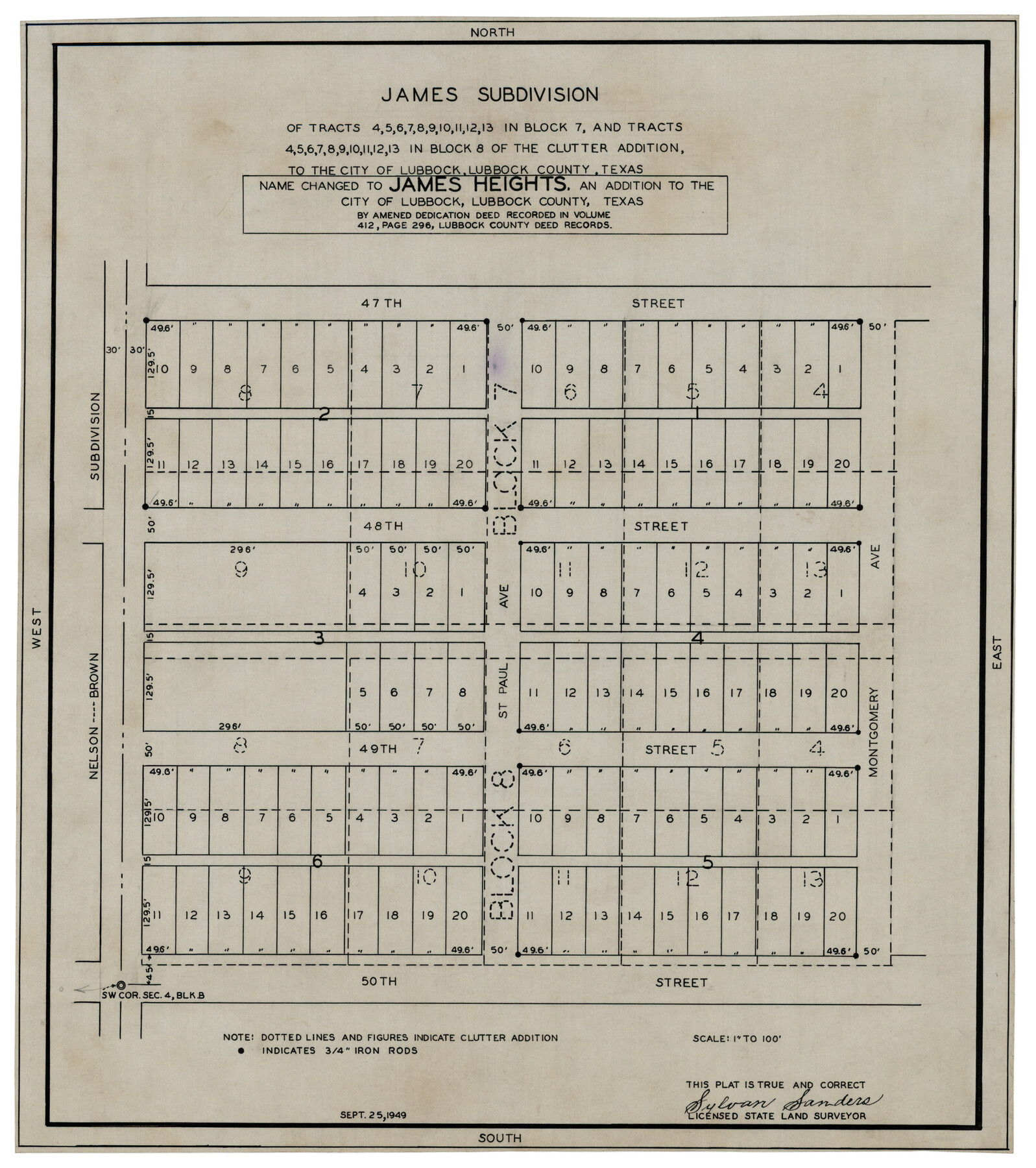
James Heights, an addition to the City of Lubbock - tracts 4, 5, 6, 7, 8, 9, 10, 11, 12, 13 in Block 7, and tracts 4, 5, 6, 7, 8, 9, 10, 11, 12, 13 in Block 8 of the Clutter Addition
-
Map/Doc
92704
-
Collection
Twichell Survey Records
-
Object Dates
9/25/1949 (Creation Date)
-
People and Organizations
Sylvan Sanders (Surveyor/Engineer)
-
Counties
Lubbock
-
Height x Width
10.1 x 11.4 inches
25.7 x 29.0 cm
Part of: Twichell Survey Records
Working Sketch Bastrop County

Print $20.00
- Digital $50.00
Working Sketch Bastrop County
1923
Size 22.7 x 13.2 inches
Map/Doc 90149
Map of the Land Purchased by C.W. Post from the US, T, and OS Ranches situated in Garza and Lynn Counties, Texas

Print $40.00
- Digital $50.00
Map of the Land Purchased by C.W. Post from the US, T, and OS Ranches situated in Garza and Lynn Counties, Texas
Size 47.6 x 57.4 inches
Map/Doc 89948
Working Sketch in Collingsworth County [showing East line of County along border with Oklahoma]
![92086, Working Sketch in Collingsworth County [showing East line of County along border with Oklahoma], Twichell Survey Records](https://historictexasmaps.com/wmedia_w700/maps/92086-1.tif.jpg)
Print $20.00
- Digital $50.00
Working Sketch in Collingsworth County [showing East line of County along border with Oklahoma]
1910
Size 4.5 x 25.9 inches
Map/Doc 92086
Plat Showing Subdivision of Wilbarger County School Land Hockley County, Texas

Print $20.00
- Digital $50.00
Plat Showing Subdivision of Wilbarger County School Land Hockley County, Texas
1947
Size 20.0 x 20.9 inches
Map/Doc 92255
Survey of Blocks 1, 2, 3, 4, 5, Merritt and Wild Addition

Print $20.00
- Digital $50.00
Survey of Blocks 1, 2, 3, 4, 5, Merritt and Wild Addition
1955
Size 23.5 x 18.3 inches
Map/Doc 92727
[Pencil sketch around J. Walters, J. G. Welchmeyer, R. Gage surveys]
![90206, [Pencil sketch around J. Walters, J. G. Welchmeyer, R. Gage surveys], Twichell Survey Records](https://historictexasmaps.com/wmedia_w700/maps/90206-1.tif.jpg)
Print $20.00
- Digital $50.00
[Pencil sketch around J. Walters, J. G. Welchmeyer, R. Gage surveys]
Size 25.5 x 21.7 inches
Map/Doc 90206
D. B. Gardner vs. Mrs. Clara C. Starr

Print $20.00
- Digital $50.00
D. B. Gardner vs. Mrs. Clara C. Starr
Size 16.3 x 28.5 inches
Map/Doc 91044
Carter Park Addition

Print $20.00
- Digital $50.00
Carter Park Addition
1952
Size 18.3 x 23.2 inches
Map/Doc 92769
![91092, [Block M-23], Twichell Survey Records](https://historictexasmaps.com/wmedia_w700/maps/91092-1.tif.jpg)
![89627, [Blks. 46 & 47], Twichell Survey Records](https://historictexasmaps.com/wmedia_w700/maps/89627-1.tif.jpg)
[S51-58, 27, 30, 303-306, 221-224, 562, 564]
![92185, [S51-58, 27, 30, 303-306, 221-224, 562, 564], Twichell Survey Records](https://historictexasmaps.com/wmedia_w700/maps/92185-1.tif.jpg)
Print $20.00
- Digital $50.00
[S51-58, 27, 30, 303-306, 221-224, 562, 564]
Size 31.1 x 15.6 inches
Map/Doc 92185
[Subdivision of Crockett County School Land Lgs. 214-217]
![90106, [Subdivision of Crockett County School Land Lgs. 214-217], Twichell Survey Records](https://historictexasmaps.com/wmedia_w700/maps/90106-1.tif.jpg)
Print $2.00
- Digital $50.00
[Subdivision of Crockett County School Land Lgs. 214-217]
Size 12.4 x 8.5 inches
Map/Doc 90106
You may also like
Kleberg County Rolled Sketch 10-13

Print $20.00
- Digital $50.00
Kleberg County Rolled Sketch 10-13
1952
Size 37.0 x 32.5 inches
Map/Doc 9391
Brewster County Rolled Sketch 88

Print $20.00
- Digital $50.00
Brewster County Rolled Sketch 88
1948
Size 23.7 x 19.7 inches
Map/Doc 5248
Bird's Eye View of the City of Houston, Texas

Print $20.00
Bird's Eye View of the City of Houston, Texas
1873
Size 24.0 x 30.9 inches
Map/Doc 89093
Falls County State Real Property Sketch 1

Print $40.00
- Digital $50.00
Falls County State Real Property Sketch 1
1999
Size 23.6 x 23.5 inches
Map/Doc 61669
Gaines County Working Sketch 30

Print $20.00
- Digital $50.00
Gaines County Working Sketch 30
1990
Size 18.3 x 26.4 inches
Map/Doc 69330
Lamar County State Real Property Sketch 1

Print $40.00
- Digital $50.00
Lamar County State Real Property Sketch 1
2013
Size 48.0 x 36.0 inches
Map/Doc 93662
North end of Brazos Island

Print $20.00
- Digital $50.00
North end of Brazos Island
Size 26.0 x 18.3 inches
Map/Doc 72915
Texas-New Mexico Boundary Along Rio Grande (plats)

Print $390.00
Texas-New Mexico Boundary Along Rio Grande (plats)
1933
Map/Doc 81691
Webb County Rolled Sketch EF2

Print $20.00
- Digital $50.00
Webb County Rolled Sketch EF2
1932
Size 40.4 x 29.9 inches
Map/Doc 8224
Map of Stephens County

Print $20.00
- Digital $50.00
Map of Stephens County
1897
Size 42.9 x 38.2 inches
Map/Doc 63044
Sketch G Showing the Progress of the Survey in Section VII From 1849 to 1852

Print $20.00
- Digital $50.00
Sketch G Showing the Progress of the Survey in Section VII From 1849 to 1852
1852
Size 13.6 x 25.8 inches
Map/Doc 97219
