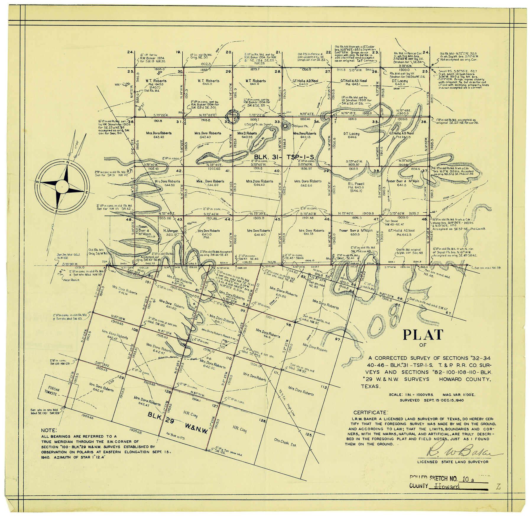
Howard County Rolled Sketch 10A
Plat of a corrected survey of sections 32, 34, 40, 46, Blk. 31 Tsp. 1S, T. & P. R.R. Co. surveys and sections 82, 100, 108, 110, Blk. 29 W & NW surveys Howard County, Texas
-
Map/Doc
6241
-
Collection
General Map Collection
-
Object Dates
12/15/1940 (Creation Date)
-
People and Organizations
R.W. Baker (Surveyor/Engineer)
-
Counties
Howard
-
Subjects
Surveying Rolled Sketch
-
Height x Width
19.9 x 20.4 inches
50.6 x 51.8 cm
-
Medium
blueprint/diazo
-
Scale
1" = 1000 varas
Part of: General Map Collection
Gulf of Mexico

Print $20.00
- Digital $50.00
Gulf of Mexico
1908
Size 18.3 x 26.9 inches
Map/Doc 72655
Calhoun County Rolled Sketch 6

Print $20.00
- Digital $50.00
Calhoun County Rolled Sketch 6
Size 24.0 x 22.5 inches
Map/Doc 5362
Brazoria County Rolled Sketch 50A

Print $20.00
- Digital $50.00
Brazoria County Rolled Sketch 50A
1932
Size 17.8 x 26.1 inches
Map/Doc 5188
Map of League City and Subdivisions comprising the M. Muldoon 2 League Grant and part of the S.F. Austin League east of G. H. & H. R.R.

Print $20.00
- Digital $50.00
Map of League City and Subdivisions comprising the M. Muldoon 2 League Grant and part of the S.F. Austin League east of G. H. & H. R.R.
1893
Size 27.7 x 37.4 inches
Map/Doc 87500
Uvalde County Sketch File 18

Print $6.00
- Digital $50.00
Uvalde County Sketch File 18
1883
Size 10.9 x 8.2 inches
Map/Doc 38997
Calhoun County Rolled Sketch 21

Print $20.00
- Digital $50.00
Calhoun County Rolled Sketch 21
1957
Size 47.2 x 37.5 inches
Map/Doc 8551
Reeves County Sketch File 4

Print $20.00
- Digital $50.00
Reeves County Sketch File 4
Size 32.8 x 12.2 inches
Map/Doc 12240
Upton County Sketch File 35

Print $14.00
- Digital $50.00
Upton County Sketch File 35
1942
Size 11.4 x 8.8 inches
Map/Doc 38886
Donley County Sketch File B1

Print $20.00
- Digital $50.00
Donley County Sketch File B1
Size 32.0 x 21.3 inches
Map/Doc 11371
Van Zandt County Sketch File 14

Print $4.00
- Digital $50.00
Van Zandt County Sketch File 14
1858
Size 7.9 x 8.1 inches
Map/Doc 39404
Milam [District]
![1948, Milam [District], General Map Collection](https://historictexasmaps.com/wmedia_w700/maps/1948.tif.jpg)
Print $40.00
- Digital $50.00
Milam [District]
1850
Size 60.8 x 46.4 inches
Map/Doc 1948
Webb County Rolled Sketch 50

Print $20.00
- Digital $50.00
Webb County Rolled Sketch 50
1943
Size 38.2 x 42.6 inches
Map/Doc 10125
You may also like
Flight Mission No. DQO-8K, Frame 8, Galveston County

Print $20.00
- Digital $50.00
Flight Mission No. DQO-8K, Frame 8, Galveston County
1952
Size 18.8 x 22.5 inches
Map/Doc 85131
Aransas County Working Sketch 19

Print $20.00
- Digital $50.00
Aransas County Working Sketch 19
1978
Size 25.1 x 31.1 inches
Map/Doc 67186
Erath County Working Sketch 17

Print $20.00
- Digital $50.00
Erath County Working Sketch 17
1962
Size 20.4 x 23.1 inches
Map/Doc 69098
Glasscock County Working Sketch 8

Print $20.00
- Digital $50.00
Glasscock County Working Sketch 8
Size 42.7 x 10.3 inches
Map/Doc 62189
Montague County Working Sketch 25

Print $20.00
- Digital $50.00
Montague County Working Sketch 25
1955
Size 42.4 x 28.4 inches
Map/Doc 71091
Dickens County Sketch File H2

Print $4.00
- Digital $50.00
Dickens County Sketch File H2
Size 12.7 x 8.1 inches
Map/Doc 20873
Flight Mission No. DAG-24K, Frame 36, Matagorda County

Print $20.00
- Digital $50.00
Flight Mission No. DAG-24K, Frame 36, Matagorda County
1953
Size 18.5 x 22.2 inches
Map/Doc 86523
San Jacinto County

Print $40.00
- Digital $50.00
San Jacinto County
1942
Size 48.7 x 43.1 inches
Map/Doc 73282
Stonewall County Sketch File 11

Print $6.00
- Digital $50.00
Stonewall County Sketch File 11
1900
Size 9.7 x 8.5 inches
Map/Doc 37237
Johnson County

Print $20.00
- Digital $50.00
Johnson County
1943
Size 42.0 x 38.8 inches
Map/Doc 73199
Hartley County Working Sketch 5

Print $20.00
- Digital $50.00
Hartley County Working Sketch 5
1957
Size 46.3 x 28.9 inches
Map/Doc 66055
Pecos County Rolled Sketch 116

Print $20.00
- Digital $50.00
Pecos County Rolled Sketch 116
Size 26.7 x 20.6 inches
Map/Doc 7259