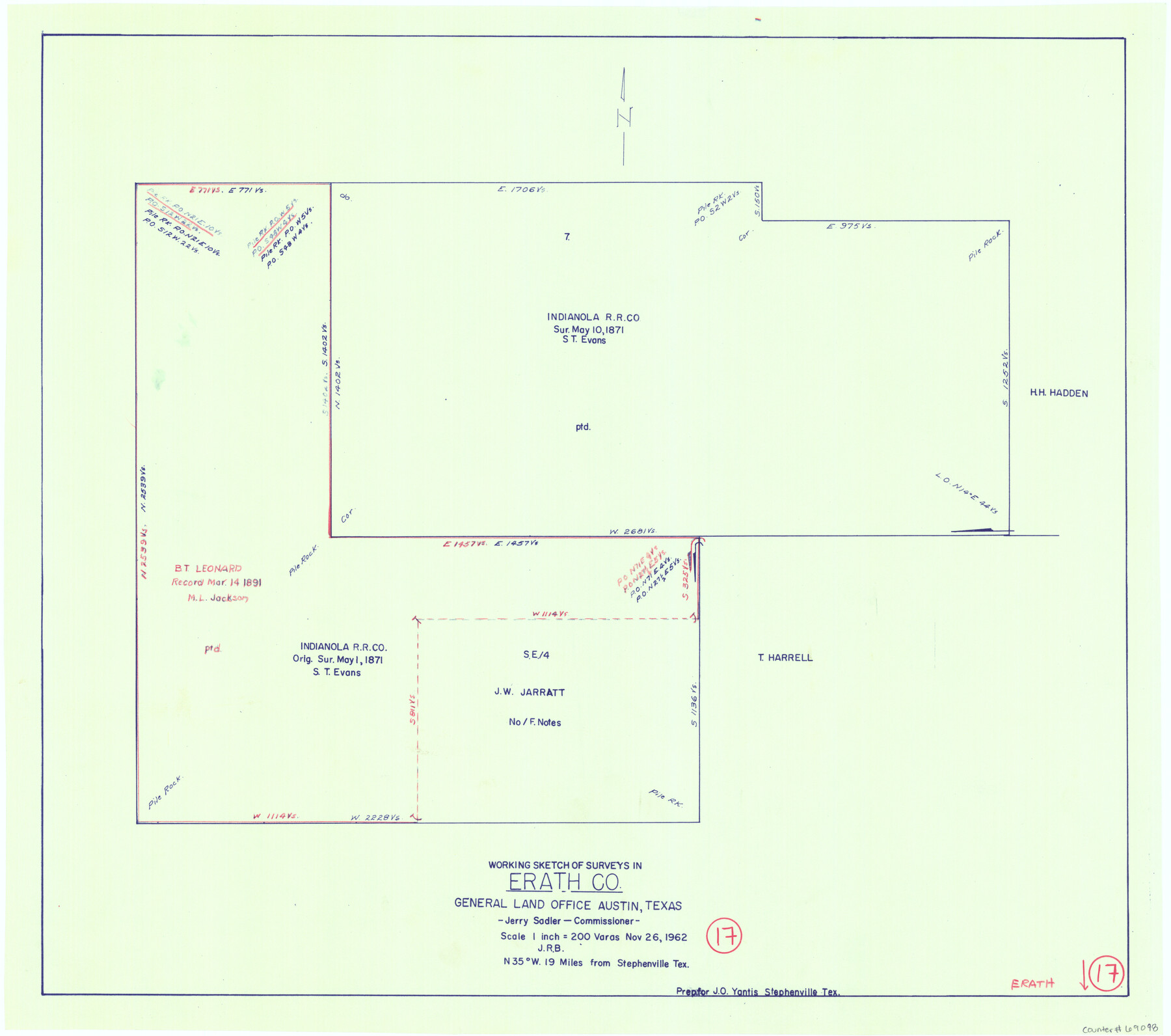
Erath County Working Sketch 17
- 
                          Map/Doc
69098
 - 
                            Collection
General Map Collection
 - 
                            Object Dates
11/26/1962 (Creation Date)
 - 
                            Counties
Erath
 - 
                            Subjects
Surveying Working Sketch
 - 
                            Height x Width
20.4 x 23.1 inches
51.8 x 58.7 cm
 - 
                            Scale
1" = 200 varas
 
Part of: General Map Collection
            Palo Pinto County Working Sketch 26


                                            Print $20.00                    
                                             -                         Digital $50.00                                    
                Palo Pinto County Working Sketch 26
1993
Map/Doc 71409
            
            Polk County Working Sketch 33a


                                            Print $20.00                    
                                             -                         Digital $50.00                                    
                Polk County Working Sketch 33a
1960
Size 30.7 x 27.4 inches
                                Map/Doc 71649
            
            Jeff Davis County Sketch File 26 1/2


                                            Print $10.00                    
                                             -                         Digital $50.00                                    
                Jeff Davis County Sketch File 26 1/2
Size 9.0 x 10.4 inches
                                Map/Doc 27999
            
            Val Verde County Sketch File 49


                                            Print $20.00                    
                                             -                         Digital $50.00                                    
                Val Verde County Sketch File 49
1953
Size 27.1 x 20.2 inches
                                Map/Doc 12590
            
            Loving County Working Sketch 2


                                            Print $20.00                    
                                             -                         Digital $50.00                                    
                Loving County Working Sketch 2
1937
Size 33.9 x 42.5 inches
                                Map/Doc 70634
            
            La Salle County Rolled Sketch 21


                                            Print $77.00                    
                                             -                         Digital $50.00                                    
                La Salle County Rolled Sketch 21
1955
Size 10.0 x 15.1 inches
                                Map/Doc 46461
            
            Polk County Sketch File 8


                                            Print $4.00                    
                                             -                         Digital $50.00                                    
                Polk County Sketch File 8
1859
Size 10.9 x 8.4 inches
                                Map/Doc 34134
            
            Ward County Rolled Sketch 27


                                            Print $20.00                    
                                             -                         Digital $50.00                                    
                Ward County Rolled Sketch 27
1982
Size 22.7 x 16.5 inches
                                Map/Doc 8166
            
            Scurry County Sketch File 1


                                            Print $6.00                    
                                             -                         Digital $50.00                                    
                Scurry County Sketch File 1
Size 14.5 x 9.1 inches
                                Map/Doc 36560
            
            Upton County Sketch File 34


                                            Print $40.00                    
                                             -                         Digital $50.00                                    
                Upton County Sketch File 34
1941
Size 16.2 x 12.2 inches
                                Map/Doc 38884
            
            Intracoastal Waterway - Gibbstown to Port Arthur


                                            Print $20.00                    
                                             -                         Digital $50.00                                    
                Intracoastal Waterway - Gibbstown to Port Arthur
1961
Size 26.6 x 38.7 inches
                                Map/Doc 69833
            You may also like
            Padre Island National Seashore


                                            Print $20.00                    
                                             -                         Digital $50.00                                    
                Padre Island National Seashore
Size 16.0 x 21.7 inches
                                Map/Doc 60537
            
            Photo Index of Texas Coast - Sheet 1 of 6


                                            Print $20.00                    
                                             -                         Digital $50.00                                    
                Photo Index of Texas Coast - Sheet 1 of 6
1954
Size 20.0 x 24.0 inches
                                Map/Doc 83438
            
            [F. W. & D. C. Ry. Co. Alignment and Right of Way Map, Clay County]


                                            Print $20.00                    
                                             -                         Digital $50.00                                    
                [F. W. & D. C. Ry. Co. Alignment and Right of Way Map, Clay County]
1927
Size 18.6 x 11.8 inches
                                Map/Doc 64734
            
            Lavaca County Rolled Sketch 1


                                            Print $20.00                    
                                             -                         Digital $50.00                                    
                Lavaca County Rolled Sketch 1
1947
Size 36.4 x 32.4 inches
                                Map/Doc 6591
            
            Map of the Surveyed Part of Young District


                                            Print $40.00                    
                                             -                         Digital $50.00                                    
                Map of the Surveyed Part of Young District
1860
Size 56.2 x 54.7 inches
                                Map/Doc 1986
            
            [Sections in the vicinity of John P. Rohus and Mary Fury surveys]


                                            Print $20.00                    
                                             -                         Digital $50.00                                    
                [Sections in the vicinity of John P. Rohus and Mary Fury surveys]
Size 12.2 x 13.1 inches
                                Map/Doc 92987
            
            Clay County Sketch File 32


                                            Print $22.00                    
                                             -                         Digital $50.00                                    
                Clay County Sketch File 32
Size 8.6 x 7.8 inches
                                Map/Doc 18458
            
            Comal County Sketch File 4


                                            Print $4.00                    
                                             -                         Digital $50.00                                    
                Comal County Sketch File 4
Size 6.0 x 8.1 inches
                                Map/Doc 19004
            
            [Sketch for Mineral Application 24072, San Jacinto River]


                                            Print $20.00                    
                                             -                         Digital $50.00                                    
                [Sketch for Mineral Application 24072, San Jacinto River]
1929
Size 19.3 x 16.4 inches
                                Map/Doc 65587
            
            The Judicial District/County of Smith. Abolished, Spring 1842


                                            Print $20.00                    
                                    
                The Judicial District/County of Smith. Abolished, Spring 1842
2020
Size 19.6 x 21.7 inches
                                Map/Doc 96347
            
            Wharton County Sketch File 4a


                                            Print $4.00                    
                                             -                         Digital $50.00                                    
                Wharton County Sketch File 4a
1876
Size 12.7 x 8.1 inches
                                Map/Doc 39919
            
            San Patricio County Sketch File 52


                                            Print $14.00                    
                                             -                         Digital $50.00                                    
                San Patricio County Sketch File 52
1917
Size 11.3 x 8.7 inches
                                Map/Doc 36381