Wilbarger County Sketch File 27
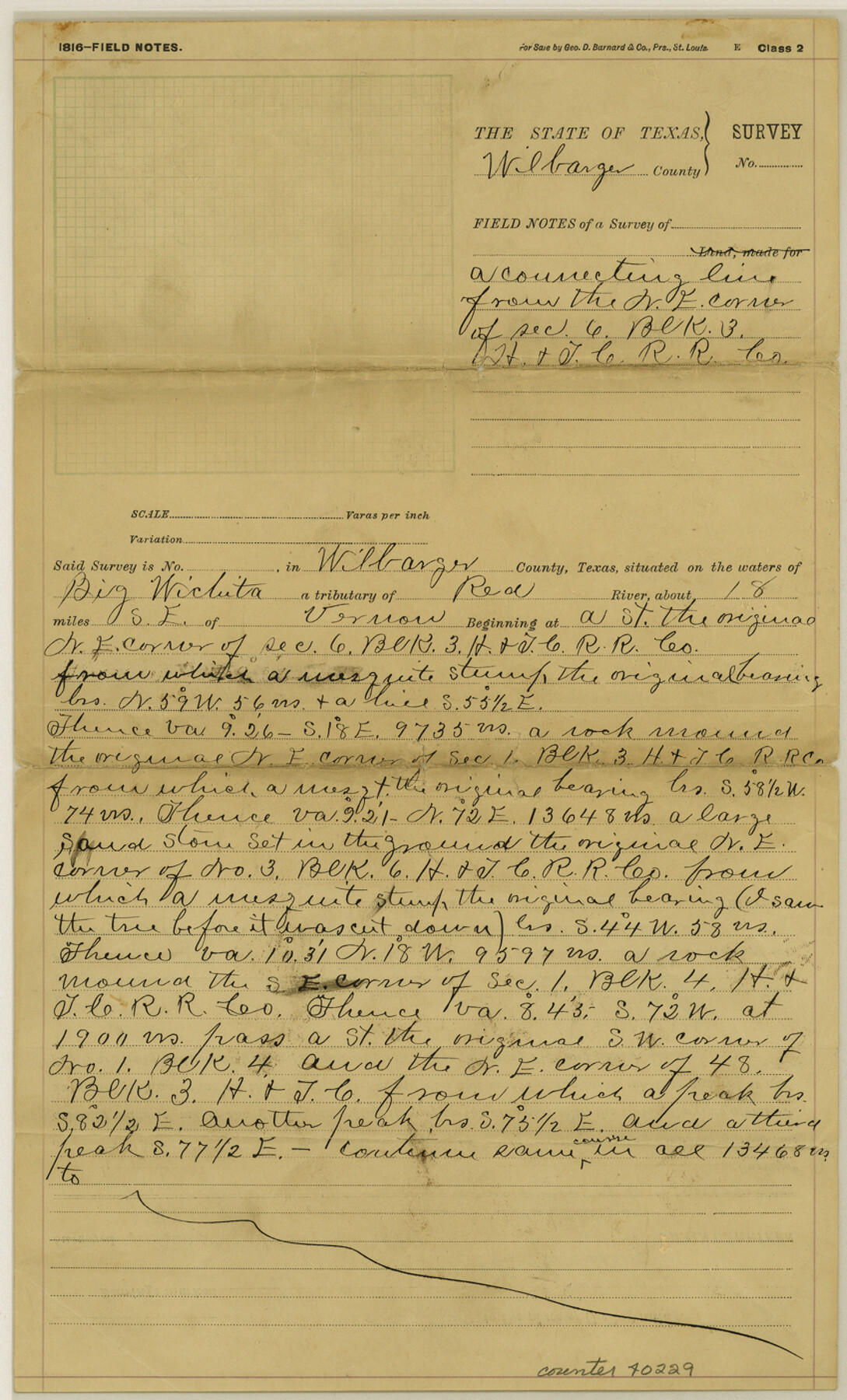
[Field notes of a connecting line from the northeast corner of section 6, Block 3, H. & T. C. R.R. Co. to the northeast corner of section 48, Block 3, H. & T. C. R.R. Co.]
-
Map/Doc
40229
-
Collection
General Map Collection
-
Object Dates
7/10/1894 (Creation Date)
-
People and Organizations
V.R. Kenney (Chainman/Field Personnel)
Richard Kenney (Chainman/Field Personnel)
R.M. Kenney (Surveyor/Engineer)
-
Counties
Wilbarger
-
Subjects
Surveying Sketch File
-
Height x Width
14.0 x 8.5 inches
35.6 x 21.6 cm
-
Medium
paper, print with manuscript additions
-
Features
Big Wichita River
Red River
Part of: General Map Collection
Reeves County Working Sketch 4a

Print $20.00
- Digital $50.00
Reeves County Working Sketch 4a
1933
Size 26.0 x 34.6 inches
Map/Doc 63447
Flight Mission No. CGI-3N, Frame 127, Cameron County

Print $20.00
- Digital $50.00
Flight Mission No. CGI-3N, Frame 127, Cameron County
1954
Size 18.8 x 22.4 inches
Map/Doc 84600
Old Miscellaneous File 13

Print $6.00
- Digital $50.00
Old Miscellaneous File 13
1899
Size 9.7 x 6.5 inches
Map/Doc 75446
Map of the Denison & South Eastern Rwy. showing the Location & Land Lines of the First Twenty-One Miles

Print $40.00
- Digital $50.00
Map of the Denison & South Eastern Rwy. showing the Location & Land Lines of the First Twenty-One Miles
1878
Size 24.1 x 70.4 inches
Map/Doc 64023
Map from the Sabine River to the Rio Grande as subdivided for mineral development

Print $20.00
- Digital $50.00
Map from the Sabine River to the Rio Grande as subdivided for mineral development
Size 30.6 x 44.8 inches
Map/Doc 65801
Railroad Track Map, H&TCRRCo., Falls County, Texas

Print $4.00
- Digital $50.00
Railroad Track Map, H&TCRRCo., Falls County, Texas
1918
Size 11.7 x 18.4 inches
Map/Doc 62862

Galveston County NRC Article 33.136 Sketch 84

Print $62.00
- Digital $50.00
Galveston County NRC Article 33.136 Sketch 84
2017
Size 17.2 x 22.0 inches
Map/Doc 94854
Stonewall County Working Sketch 17

Print $20.00
- Digital $50.00
Stonewall County Working Sketch 17
1954
Size 31.5 x 24.7 inches
Map/Doc 62324
Kinney County Working Sketch 22

Print $20.00
- Digital $50.00
Kinney County Working Sketch 22
1950
Size 46.5 x 37.2 inches
Map/Doc 70204
Jasper County

Print $20.00
- Digital $50.00
Jasper County
1946
Size 46.8 x 41.0 inches
Map/Doc 77325
Lampasas County Sketch File 18

Print $4.00
- Digital $50.00
Lampasas County Sketch File 18
Size 8.1 x 4.8 inches
Map/Doc 29430
You may also like
Montgomery County Working Sketch 49

Print $20.00
- Digital $50.00
Montgomery County Working Sketch 49
1959
Size 13.8 x 12.0 inches
Map/Doc 71156
Dimmit County Boundary File 9

Print $20.00
- Digital $50.00
Dimmit County Boundary File 9
Size 37.2 x 6.9 inches
Map/Doc 52603
Webb County Working Sketch 5

Print $20.00
- Digital $50.00
Webb County Working Sketch 5
1909
Size 20.1 x 15.4 inches
Map/Doc 72370
Map of Cherokee County

Print $20.00
- Digital $50.00
Map of Cherokee County
1851
Size 24.6 x 18.3 inches
Map/Doc 3386
Hays County Sketch File 13a

Print $40.00
- Digital $50.00
Hays County Sketch File 13a
Size 12.3 x 15.0 inches
Map/Doc 26223
Edwards County Working Sketch 107

Print $40.00
- Digital $50.00
Edwards County Working Sketch 107
1972
Size 54.5 x 38.8 inches
Map/Doc 68983
Burnet County Sketch File 44

Print $10.00
- Digital $50.00
Burnet County Sketch File 44
1936
Size 11.3 x 8.8 inches
Map/Doc 16767
Jefferson County Sketch File 47

Print $20.00
- Digital $50.00
Jefferson County Sketch File 47
1898
Size 27.2 x 19.1 inches
Map/Doc 11881
Map of the Military Department of the Gulf

Print $20.00
Map of the Military Department of the Gulf
1864
Size 24.4 x 45.7 inches
Map/Doc 93568
Terrell County Working Sketch 10

Print $20.00
- Digital $50.00
Terrell County Working Sketch 10
1924
Size 28.0 x 25.9 inches
Map/Doc 62159
Hudspeth County Working Sketch 62

Print $20.00
- Digital $50.00
Hudspeth County Working Sketch 62
1993
Size 23.9 x 32.4 inches
Map/Doc 66347
Burleson County Working Sketch 1

Print $20.00
- Digital $50.00
Burleson County Working Sketch 1
1928
Size 23.4 x 17.4 inches
Map/Doc 67720