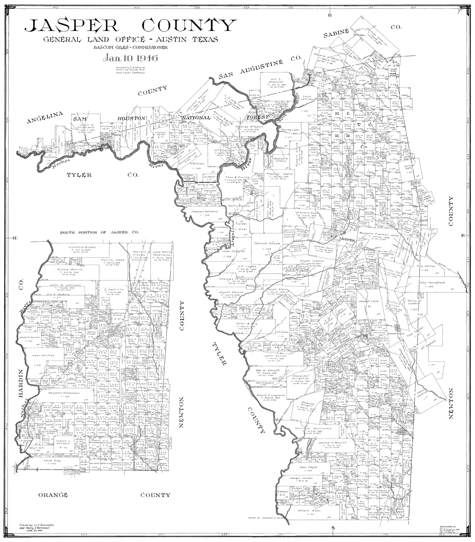
Jasper County
-
Map/Doc
77325
-
Collection
General Map Collection
-
Object Dates
1946/1/10 (Creation Date)
-
People and Organizations
Tommye Buie (Draftsman)
Victor E. Sterzing (Compiler)
-
Counties
Jasper
-
Subjects
County
-
Height x Width
46.8 x 41.0 inches
118.9 x 104.1 cm
Part of: General Map Collection
Montgomery County Sketch File 18

Print $20.00
- Digital $50.00
Montgomery County Sketch File 18
1899
Size 22.1 x 19.6 inches
Map/Doc 42122
Brewster County Working Sketch 23

Print $20.00
- Digital $50.00
Brewster County Working Sketch 23
1939
Size 26.7 x 43.6 inches
Map/Doc 67557
Hemphill County Rolled Sketch 6

Print $20.00
- Digital $50.00
Hemphill County Rolled Sketch 6
Size 22.2 x 24.7 inches
Map/Doc 6188
Taylor County Rolled Sketch 20

Print $20.00
- Digital $50.00
Taylor County Rolled Sketch 20
Size 25.6 x 33.9 inches
Map/Doc 7914
Township 8 North Range 14 West, North Western District, Louisiana

Print $20.00
- Digital $50.00
Township 8 North Range 14 West, North Western District, Louisiana
1854
Size 19.7 x 24.7 inches
Map/Doc 65874
Stephens County Rolled Sketch 5

Print $20.00
- Digital $50.00
Stephens County Rolled Sketch 5
Size 23.2 x 37.2 inches
Map/Doc 7842
Victoria County Rolled Sketch 3

Print $20.00
- Digital $50.00
Victoria County Rolled Sketch 3
1950
Size 41.9 x 37.8 inches
Map/Doc 10094
Burnet County Sketch File 18

Print $4.00
- Digital $50.00
Burnet County Sketch File 18
1873
Size 8.3 x 6.5 inches
Map/Doc 16708

Fort Bend County Sketch File 21

Print $4.00
- Digital $50.00
Fort Bend County Sketch File 21
1882
Size 8.8 x 13.4 inches
Map/Doc 22954
Flight Mission No. CRC-1R, Frame 152, Chambers County

Print $20.00
- Digital $50.00
Flight Mission No. CRC-1R, Frame 152, Chambers County
1956
Size 18.8 x 22.5 inches
Map/Doc 84714
Travis County State Real Property Sketch 4

Print $20.00
- Digital $50.00
Travis County State Real Property Sketch 4
1987
Size 25.7 x 30.7 inches
Map/Doc 61695
You may also like
Harris County Working Sketch 37

Print $20.00
- Digital $50.00
Harris County Working Sketch 37
1938
Size 25.4 x 28.0 inches
Map/Doc 65929
Gonzales County Working Sketch 9

Print $20.00
- Digital $50.00
Gonzales County Working Sketch 9
1981
Size 18.8 x 18.2 inches
Map/Doc 63225
General Highway Map, Brewster County, Texas

Print $20.00
General Highway Map, Brewster County, Texas
1961
Size 18.3 x 24.9 inches
Map/Doc 79386
Red River, Bois D'Arc Creek Floodway Sheet No. 5

Print $20.00
- Digital $50.00
Red River, Bois D'Arc Creek Floodway Sheet No. 5
1915
Size 22.3 x 31.9 inches
Map/Doc 69660
La Salle County Sketch File 46

Print $20.00
- Digital $50.00
La Salle County Sketch File 46
Size 14.1 x 8.6 inches
Map/Doc 29603
Concho County Sketch File 43

Print $6.00
- Digital $50.00
Concho County Sketch File 43
1948
Size 14.4 x 8.9 inches
Map/Doc 19204
Cochran County

Print $20.00
- Digital $50.00
Cochran County
1946
Size 30.8 x 23.1 inches
Map/Doc 77239
Concho County Working Sketch 3

Print $20.00
- Digital $50.00
Concho County Working Sketch 3
1918
Size 24.0 x 22.2 inches
Map/Doc 68185
Duval County Working Sketch 21

Print $20.00
- Digital $50.00
Duval County Working Sketch 21
1941
Size 16.9 x 11.8 inches
Map/Doc 68745
Part of Tom Green County, Texas (No. 2)

Print $20.00
- Digital $50.00
Part of Tom Green County, Texas (No. 2)
1870
Size 22.9 x 18.0 inches
Map/Doc 5046
Map of the Stockdale-Cuero Extension G.H. & S.A. Ry.

Print $40.00
- Digital $50.00
Map of the Stockdale-Cuero Extension G.H. & S.A. Ry.
1905
Size 19.6 x 122.7 inches
Map/Doc 64094
San Patricio County Rolled Sketch 29A

Print $20.00
- Digital $50.00
San Patricio County Rolled Sketch 29A
1934
Size 37.7 x 45.7 inches
Map/Doc 9895