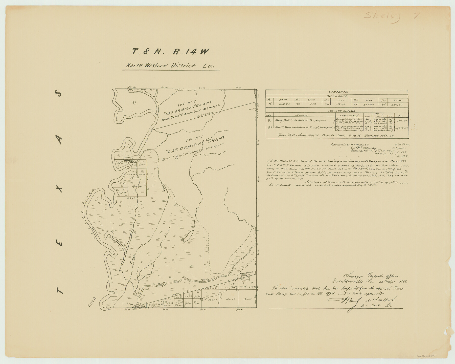
Township 8 North Range 14 West, North Western District, Louisiana
Louisiana Land Surveys Across From Shelby County, Texas 7
-
Map/Doc
65874
-
Collection
General Map Collection
-
Object Dates
1854 (Creation Date)
-
People and Organizations
Surveyor General's Office Louisiana (Publisher)
Geo. S. Walmsley (Surveyor/Engineer)
Thomas Hunter (Surveyor/Engineer)
-
Subjects
Texas Boundaries
-
Height x Width
19.7 x 24.7 inches
50.0 x 62.7 cm
Part of: General Map Collection
Lynn County Boundary File 7b

Print $8.00
- Digital $50.00
Lynn County Boundary File 7b
Size 11.3 x 8.6 inches
Map/Doc 56651
Polk County Working Sketch 36

Print $20.00
- Digital $50.00
Polk County Working Sketch 36
1963
Size 28.4 x 38.1 inches
Map/Doc 71653
Stephens County Working Sketch 26

Print $20.00
- Digital $50.00
Stephens County Working Sketch 26
1976
Size 36.9 x 32.2 inches
Map/Doc 63969
Potter County Working Sketch Graphic Index

Print $20.00
- Digital $50.00
Potter County Working Sketch Graphic Index
1960
Size 42.3 x 33.1 inches
Map/Doc 76669
Crockett County Working Sketch 73

Print $20.00
- Digital $50.00
Crockett County Working Sketch 73
1963
Size 38.8 x 33.8 inches
Map/Doc 68406
Flight Mission No. CLL-1N, Frame 83, Willacy County

Print $20.00
- Digital $50.00
Flight Mission No. CLL-1N, Frame 83, Willacy County
1954
Size 18.3 x 22.0 inches
Map/Doc 87029
Sutton County Working Sketch 20

Print $20.00
- Digital $50.00
Sutton County Working Sketch 20
1978
Size 34.5 x 27.4 inches
Map/Doc 62363
Grayson County Working Sketch 20

Print $20.00
- Digital $50.00
Grayson County Working Sketch 20
1956
Size 25.4 x 31.3 inches
Map/Doc 63259
Refugio County Working Sketch 6

Print $20.00
- Digital $50.00
Refugio County Working Sketch 6
1939
Size 21.4 x 29.1 inches
Map/Doc 63515
Flight Mission No. DCL-7C, Frame 118, Kenedy County

Print $20.00
- Digital $50.00
Flight Mission No. DCL-7C, Frame 118, Kenedy County
1943
Size 18.4 x 22.3 inches
Map/Doc 86083
Houston, Capital of Texas, 1837

Print $21.65
Houston, Capital of Texas, 1837
2007
Size 17.4 x 24.3 inches
Map/Doc 89272
San Jacinto County

Print $20.00
- Digital $50.00
San Jacinto County
1942
Size 47.1 x 42.8 inches
Map/Doc 63017
You may also like
Navarro County Boundary File 2

Print $12.00
- Digital $50.00
Navarro County Boundary File 2
Size 8.8 x 3.9 inches
Map/Doc 57608
Glasscock County Sketch File 12

Print $5.00
- Digital $50.00
Glasscock County Sketch File 12
1935
Size 14.1 x 9.2 inches
Map/Doc 24176
Mills County Sketch File 25

Print $8.00
- Digital $50.00
Mills County Sketch File 25
1949
Size 11.3 x 8.8 inches
Map/Doc 31674

Dimmit County Sketch File 57

Print $6.00
- Digital $50.00
Dimmit County Sketch File 57
1941
Size 14.3 x 8.8 inches
Map/Doc 21190
Topographical Map of the Rio Grande from Roma to the Gulf of Mexico, Index Map, Sheet No. 1

Print $20.00
- Digital $50.00
Topographical Map of the Rio Grande from Roma to the Gulf of Mexico, Index Map, Sheet No. 1
1912
Map/Doc 89523
Lampasas County Sketch File 21

Print $14.00
- Digital $50.00
Lampasas County Sketch File 21
2001
Size 14.2 x 8.8 inches
Map/Doc 29436

Harris County Rolled Sketch T2

Print $20.00
- Digital $50.00
Harris County Rolled Sketch T2
1916
Size 26.8 x 23.2 inches
Map/Doc 6145
Grimes Estate Lands, Cochran County, Texas

Print $20.00
- Digital $50.00
Grimes Estate Lands, Cochran County, Texas
Size 25.6 x 21.6 inches
Map/Doc 92520
Red River County Sketch File 20

Print $4.00
- Digital $50.00
Red River County Sketch File 20
Size 8.2 x 10.1 inches
Map/Doc 35152
La Salle County Sketch File 47

Print $8.00
- Digital $50.00
La Salle County Sketch File 47
1941
Size 14.2 x 8.9 inches
Map/Doc 29613