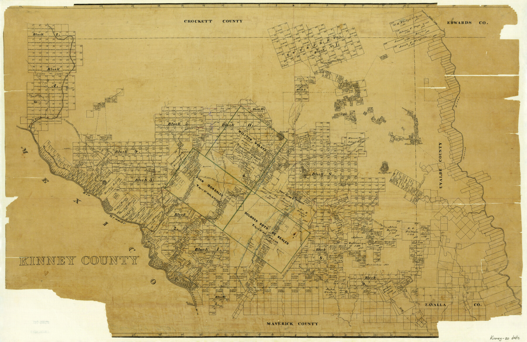
Kinney County
-
Map/Doc
3777
-
Collection
General Map Collection
-
Counties
Kinney
-
Subjects
County
-
Height x Width
24.0 x 36.4 inches
61.0 x 92.5 cm
-
Features
Fort Clark
Rio Grande
Scavenger Creek
Onion Creek
San Felipe
Conical Hill
Devil's River
El Paso Road
Brackett
Sacatosa Creek
Elm Creek
Olmos Mountain
Arenosa Creek
Turkey Creek Mountain
E[ast] P[rong] of San Pedro Arroyo
Ellipsis Mountain
Grass Valley Creek
Chaparosa Creek
Paint Creek
San Diego [River]
Salado Creek
Lindsay Creek
Road to Griffin Valley
Peloncillo [Mountain]
Peloncillo
Muela Creek
[Road] to Fort McKavett
Cow Creek
Cave Creek
San Antonio Stage Road
Las Moras Creek
West Prong of Piedra Pinto Creek
East Prong of Piedra Pinto Creek
Piedra Pinto Creek
Lone Hill
San Felipe Creek
Sinegas Creek
Camp Hudson Road
Fort Lancaster Road
[Road] to Fort Lancaster and Camp Hudson
Devil's River
Painted Cave Creek
West Prong of Painted Cave Creek
West Fork [of Sycamore Creek]
Griffin Creek
Battleground August 10, 1863
Live Oak Creek
[Silver Lake] Island
Silver Lake
Middle Prong [of Nueces River]
Nueces River
West Pinto Creek
[Road] to Nueces River
[Road] to Nueces River and Fort McKavett
Las Moras Mountains
[Road] to Griffin Valley
Bluff Creek
Little Pinto Mountain
Pinto Mountain
East Pinta [sic] [Creek]
West Fork of Nueces River
Big Perdido [Creek]
Little Perdido Creek
Maverick Creek
Mud Creek
Gladesburg
Sycamore Creek
East Fork [of Sycamore Creek]
Part of: General Map Collection
Edwards County Sketch File 56

Print $32.00
- Digital $50.00
Edwards County Sketch File 56
1915
Size 11.4 x 9.0 inches
Map/Doc 21808
Flight Mission No. DQN-2K, Frame 74, Calhoun County

Print $20.00
- Digital $50.00
Flight Mission No. DQN-2K, Frame 74, Calhoun County
1953
Size 18.6 x 22.2 inches
Map/Doc 84266
Flight Mission No. DQO-8K, Frame 77, Galveston County

Print $20.00
- Digital $50.00
Flight Mission No. DQO-8K, Frame 77, Galveston County
1952
Size 18.9 x 22.5 inches
Map/Doc 85181
Bexar County Sketch File 42a

Print $4.00
- Digital $50.00
Bexar County Sketch File 42a
Size 8.0 x 9.6 inches
Map/Doc 14520
Flight Mission No. CRC-6R, Frame 41, Chambers County

Print $20.00
- Digital $50.00
Flight Mission No. CRC-6R, Frame 41, Chambers County
1956
Size 18.4 x 22.3 inches
Map/Doc 84974
Nueces County Rolled Sketch 27A

Print $40.00
- Digital $50.00
Nueces County Rolled Sketch 27A
1946
Size 12.4 x 121.3 inches
Map/Doc 9597
Dimmit County Sketch File 34

Print $4.00
- Digital $50.00
Dimmit County Sketch File 34
1884
Size 9.0 x 8.7 inches
Map/Doc 21153
Pecos County Rolled Sketch 22

Print $40.00
- Digital $50.00
Pecos County Rolled Sketch 22
1886
Size 73.4 x 45.2 inches
Map/Doc 93461
Concho County Working Sketch 21

Print $20.00
- Digital $50.00
Concho County Working Sketch 21
1957
Size 36.4 x 36.0 inches
Map/Doc 68203
Real County Working Sketch 9

Print $20.00
- Digital $50.00
Real County Working Sketch 9
1929
Size 18.4 x 19.5 inches
Map/Doc 71901
Goliad County Sketch File 23

Print $4.00
- Digital $50.00
Goliad County Sketch File 23
1877
Size 8.1 x 12.8 inches
Map/Doc 24295
Flight Mission No. CLL-1N, Frame 103, Willacy County

Print $20.00
- Digital $50.00
Flight Mission No. CLL-1N, Frame 103, Willacy County
1954
Size 18.4 x 22.1 inches
Map/Doc 87037
You may also like
[Townships 4N and 5N]
![90633, [Townships 4N and 5N], Twichell Survey Records](https://historictexasmaps.com/wmedia_w700/90633.tif.jpg)
Print $20.00
- Digital $50.00
[Townships 4N and 5N]
Size 23.6 x 27.1 inches
Map/Doc 90633
Crockett County Rolled Sketch 71

Print $40.00
- Digital $50.00
Crockett County Rolled Sketch 71
1949
Size 54.5 x 38.9 inches
Map/Doc 8722
Crane County Rolled Sketch 14

Print $46.00
- Digital $50.00
Crane County Rolled Sketch 14
1935
Size 37.1 x 31.6 inches
Map/Doc 8680
![90260, [League 271], Twichell Survey Records](https://historictexasmaps.com/wmedia_w700/maps/90260-1.tif.jpg)

Flight Mission No. BQY-15M, Frame 19, Harris County

Print $20.00
- Digital $50.00
Flight Mission No. BQY-15M, Frame 19, Harris County
1953
Size 18.6 x 22.4 inches
Map/Doc 85317
Brewster County Sketch File N-30

Print $6.00
- Digital $50.00
Brewster County Sketch File N-30
1969
Size 11.2 x 8.9 inches
Map/Doc 15708
Map of Padre Island

Print $40.00
- Digital $50.00
Map of Padre Island
Size 74.6 x 22.8 inches
Map/Doc 76020
Red River County Sketch File 21

Print $4.00
- Digital $50.00
Red River County Sketch File 21
Size 12.7 x 7.9 inches
Map/Doc 35154
Milam County Working Sketch Graphic Index

Print $40.00
- Digital $50.00
Milam County Working Sketch Graphic Index
1975
Size 51.6 x 42.7 inches
Map/Doc 76642
Flight Mission No. CZW-1R, Frame 165, Hardeman County

Print $20.00
- Digital $50.00
Flight Mission No. CZW-1R, Frame 165, Hardeman County
1956
Size 18.7 x 22.4 inches
Map/Doc 85236
Archer County Sketch File 23

Print $40.00
- Digital $50.00
Archer County Sketch File 23
1936
Size 25.3 x 23.4 inches
Map/Doc 10831