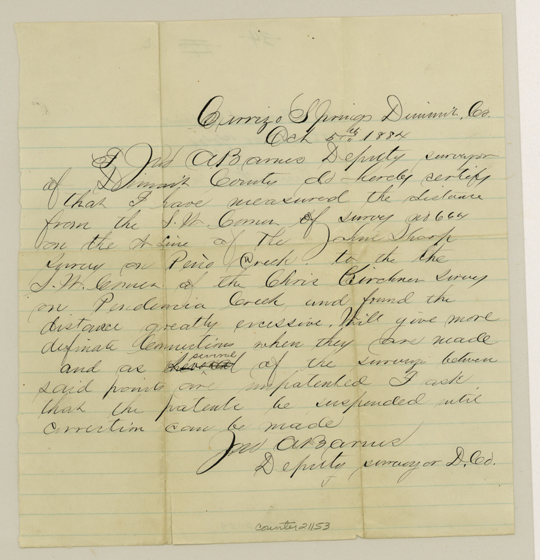
Dimmit County Sketch File 34
[Statement regarding connection from north line of John Sharp survey to southwest corner of Kirchner]
-
Map/Doc
21153
-
Collection
General Map Collection
-
Object Dates
1884/10/5 (Creation Date)
-
People and Organizations
Jno. A. Barnes (Surveyor/Engineer)
-
Counties
Dimmit
-
Subjects
Surveying Sketch File
-
Height x Width
9.0 x 8.7 inches
22.9 x 22.1 cm
-
Medium
paper, manuscript
-
Features
Pena Creek
Pendencia Creek
Part of: General Map Collection
Coleman County Sketch File 31

Print $20.00
- Digital $50.00
Coleman County Sketch File 31
Size 31.2 x 41.9 inches
Map/Doc 10339
Flight Mission No. CGI-3N, Frame 106, Cameron County

Print $20.00
- Digital $50.00
Flight Mission No. CGI-3N, Frame 106, Cameron County
1954
Size 18.5 x 22.2 inches
Map/Doc 84586
Palo Pinto County Working Sketch 4

Print $20.00
- Digital $50.00
Palo Pinto County Working Sketch 4
1913
Map/Doc 71387
Outer Continental Shelf Leasing Maps (Louisiana Offshore Operations)

Print $20.00
- Digital $50.00
Outer Continental Shelf Leasing Maps (Louisiana Offshore Operations)
1959
Size 17.9 x 13.8 inches
Map/Doc 76101
Edwards County Boundary File 1

Print $18.00
- Digital $50.00
Edwards County Boundary File 1
Size 15.5 x 5.5 inches
Map/Doc 52853
Map of Jack County

Print $20.00
- Digital $50.00
Map of Jack County
1896
Size 20.3 x 17.7 inches
Map/Doc 3699
Brewster County Sketch File C-1

Print $14.00
- Digital $50.00
Brewster County Sketch File C-1
1911
Size 11.2 x 8.9 inches
Map/Doc 15719
Johnson County Rolled Sketch 1

Print $20.00
- Digital $50.00
Johnson County Rolled Sketch 1
1941
Size 19.4 x 33.4 inches
Map/Doc 6446
McCulloch County Rolled Sketch 11

Print $20.00
- Digital $50.00
McCulloch County Rolled Sketch 11
1992
Size 46.3 x 40.3 inches
Map/Doc 9499
Briscoe County Sketch File K

Print $40.00
- Digital $50.00
Briscoe County Sketch File K
1920
Size 31.9 x 21.0 inches
Map/Doc 11008
Irion County Boundary File 3

Print $38.00
- Digital $50.00
Irion County Boundary File 3
Size 8.8 x 4.2 inches
Map/Doc 55339
Throckmorton County Rolled Sketch 4

Print $20.00
- Digital $50.00
Throckmorton County Rolled Sketch 4
1993
Size 23.0 x 35.0 inches
Map/Doc 7990
You may also like
La Salle County Working Sketch 24

Print $20.00
- Digital $50.00
La Salle County Working Sketch 24
1947
Size 20.9 x 31.2 inches
Map/Doc 70325
Southern Part of Laguna Madre

Print $20.00
- Digital $50.00
Southern Part of Laguna Madre
1936
Size 44.0 x 35.3 inches
Map/Doc 73533
Hood County Working Sketch 1

Print $20.00
- Digital $50.00
Hood County Working Sketch 1
1934
Size 18.2 x 24.5 inches
Map/Doc 66195
Flight Mission No. CGI-1N, Frame 177, Cameron County

Print $20.00
- Digital $50.00
Flight Mission No. CGI-1N, Frame 177, Cameron County
1955
Size 18.5 x 17.6 inches
Map/Doc 84512
A Topographical Map of The Government Tract Adjoining the City of Austin

Print $20.00
- Digital $50.00
A Topographical Map of The Government Tract Adjoining the City of Austin
1840
Size 44.5 x 36.0 inches
Map/Doc 82031
Chart of the Rio Bravo del Norte traced from a survey made by Henry Austin by Lieut. Bowman, 3d. Infy.

Print $20.00
- Digital $50.00
Chart of the Rio Bravo del Norte traced from a survey made by Henry Austin by Lieut. Bowman, 3d. Infy.
1866
Size 18.1 x 27.2 inches
Map/Doc 72890
Right of Way and Track Map of The Wichita Falls & Southern Railroad Company

Print $40.00
- Digital $50.00
Right of Way and Track Map of The Wichita Falls & Southern Railroad Company
1942
Size 24.5 x 56.3 inches
Map/Doc 64517
Flight Mission No. DQO-3K, Frame 14, Galveston County

Print $20.00
- Digital $50.00
Flight Mission No. DQO-3K, Frame 14, Galveston County
1952
Size 18.8 x 22.4 inches
Map/Doc 85055
Colorado County Sketch File 13

Print $4.00
- Digital $50.00
Colorado County Sketch File 13
Size 12.5 x 8.3 inches
Map/Doc 18937
Chambers County Working Sketch Graphic Index

Print $20.00
- Digital $50.00
Chambers County Working Sketch Graphic Index
1922
Size 39.3 x 47.3 inches
Map/Doc 76491
Kendall County Working Sketch Graphic Index

Print $20.00
- Digital $50.00
Kendall County Working Sketch Graphic Index
1946
Size 40.3 x 34.8 inches
Map/Doc 76602
El Paso County Working Sketch 56

Print $40.00
- Digital $50.00
El Paso County Working Sketch 56
1971
Size 65.7 x 43.4 inches
Map/Doc 69078