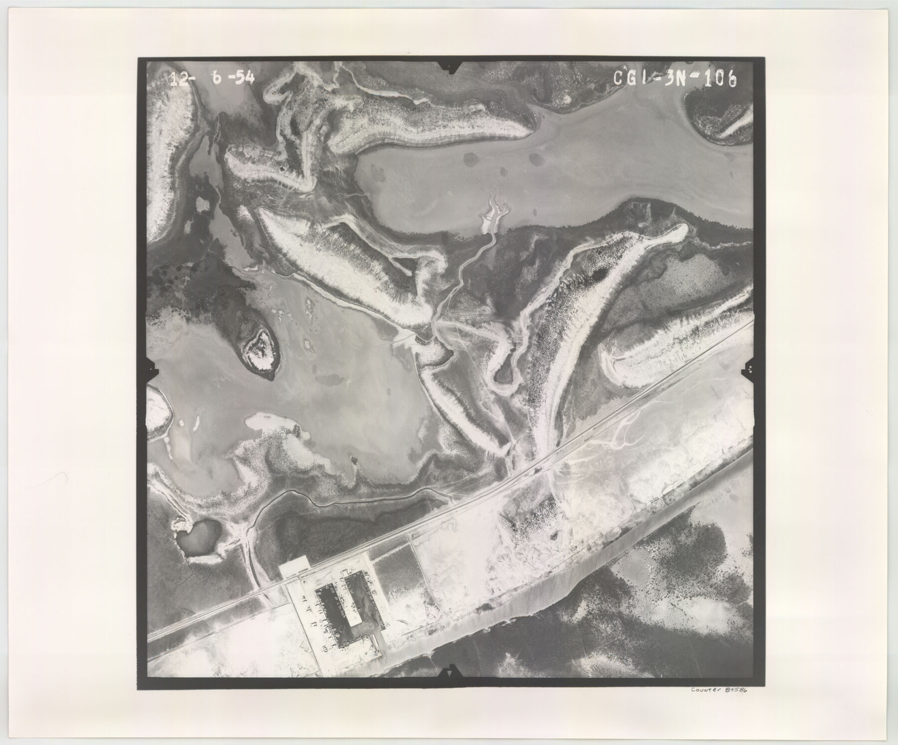
Flight Mission No. CGI-3N, Frame 106, Cameron County
CGI-3N-106
-
Map/Doc
84586
-
Collection
General Map Collection
-
Object Dates
1954/12/6 (Creation Date)
-
People and Organizations
U. S. Department of Agriculture (Publisher)
-
Counties
Cameron
-
Subjects
Aerial Photograph
-
Height x Width
18.5 x 22.2 inches
47.0 x 56.4 cm
-
Comments
Flown by Puckett Aerial Surveys, Inc. of Jackson, Mississippi.
Part of: General Map Collection
Flight Mission No. DQO-8K, Frame 66, Galveston County

Print $20.00
- Digital $50.00
Flight Mission No. DQO-8K, Frame 66, Galveston County
1952
Size 18.7 x 22.4 inches
Map/Doc 85170
Flight Mission No. CGI-3N, Frame 131, Cameron County

Print $20.00
- Digital $50.00
Flight Mission No. CGI-3N, Frame 131, Cameron County
1954
Size 18.7 x 22.3 inches
Map/Doc 84604

Swisher County Rolled Sketch 4

Print $20.00
- Digital $50.00
Swisher County Rolled Sketch 4
1904
Size 16.2 x 18.0 inches
Map/Doc 7905
McLennan County Boundary File 3

Print $8.00
- Digital $50.00
McLennan County Boundary File 3
Size 11.2 x 8.7 inches
Map/Doc 56963
Kenedy County Rolled Sketch 6

Print $20.00
- Digital $50.00
Kenedy County Rolled Sketch 6
1911
Size 28.5 x 25.4 inches
Map/Doc 6463
Polk County Sketch File 30b

Print $4.00
- Digital $50.00
Polk County Sketch File 30b
Size 6.5 x 7.9 inches
Map/Doc 34219
Hardeman County Working Sketch 16

Print $20.00
- Digital $50.00
Hardeman County Working Sketch 16
1982
Size 35.7 x 45.1 inches
Map/Doc 63397
McLennan County Working Sketch 6

Print $20.00
- Digital $50.00
McLennan County Working Sketch 6
1957
Size 26.7 x 24.8 inches
Map/Doc 70699
Amistad International Reservoir on Rio Grande 78a

Print $20.00
- Digital $50.00
Amistad International Reservoir on Rio Grande 78a
1949
Size 28.5 x 40.1 inches
Map/Doc 75507
Fayette County Working Sketch 3

Print $20.00
- Digital $50.00
Fayette County Working Sketch 3
1980
Size 29.0 x 36.3 inches
Map/Doc 69167
Hardin County Working Sketch 42

Print $20.00
- Digital $50.00
Hardin County Working Sketch 42
1917
Size 16.2 x 22.1 inches
Map/Doc 63441
You may also like
Stonewall County

Print $20.00
- Digital $50.00
Stonewall County
1879
Size 22.7 x 19.1 inches
Map/Doc 4058
No. 2 Chart of Corpus Christi Pass, Texas

Print $20.00
- Digital $50.00
No. 2 Chart of Corpus Christi Pass, Texas
1878
Size 18.3 x 27.4 inches
Map/Doc 73022
Hamilton County Sketch File 2

Print $4.00
- Digital $50.00
Hamilton County Sketch File 2
1854
Size 12.2 x 7.9 inches
Map/Doc 24899
Ector County Working Sketch 34
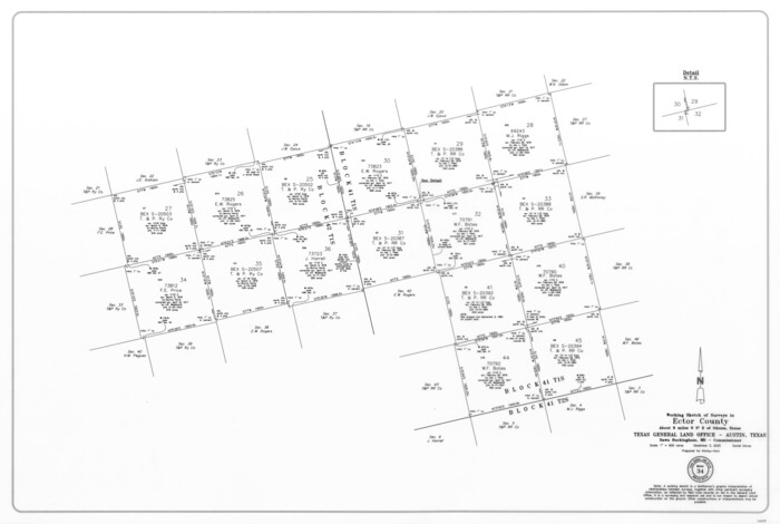
Print $20.00
- Digital $50.00
Ector County Working Sketch 34
2025
Size 22.6 x 33.6 inches
Map/Doc 97515
Medina County

Print $40.00
- Digital $50.00
Medina County
1976
Size 53.5 x 44.2 inches
Map/Doc 95587
Hays County Rolled Sketch 33

Print $20.00
- Digital $50.00
Hays County Rolled Sketch 33
Size 15.4 x 19.1 inches
Map/Doc 89012
Map of Eastland Co[unty]
![88929, Map of Eastland Co[unty], Library of Congress](https://historictexasmaps.com/wmedia_w700/maps/88929.tif.jpg)
Print $20.00
Map of Eastland Co[unty]
1896
Size 45.0 x 42.8 inches
Map/Doc 88929
Medina County Rolled Sketch 9

Print $20.00
- Digital $50.00
Medina County Rolled Sketch 9
Size 18.8 x 31.0 inches
Map/Doc 6743
Zapata County Rolled Sketch 22

Print $20.00
- Digital $50.00
Zapata County Rolled Sketch 22
1958
Size 29.2 x 21.5 inches
Map/Doc 8317
[Sketch for Mineral Application 16777]
![65656, [Sketch for Mineral Application 16777], General Map Collection](https://historictexasmaps.com/wmedia_w700/maps/65656-1.tif.jpg)
Print $40.00
- Digital $50.00
[Sketch for Mineral Application 16777]
Size 80.3 x 20.0 inches
Map/Doc 65656
Waller County Sketch File 6

Print $12.00
- Digital $50.00
Waller County Sketch File 6
Size 13.1 x 6.3 inches
Map/Doc 39602
Brooks County Sketch File 10

Print $2.00
- Digital $50.00
Brooks County Sketch File 10
1988
Size 14.4 x 9.0 inches
Map/Doc 16572