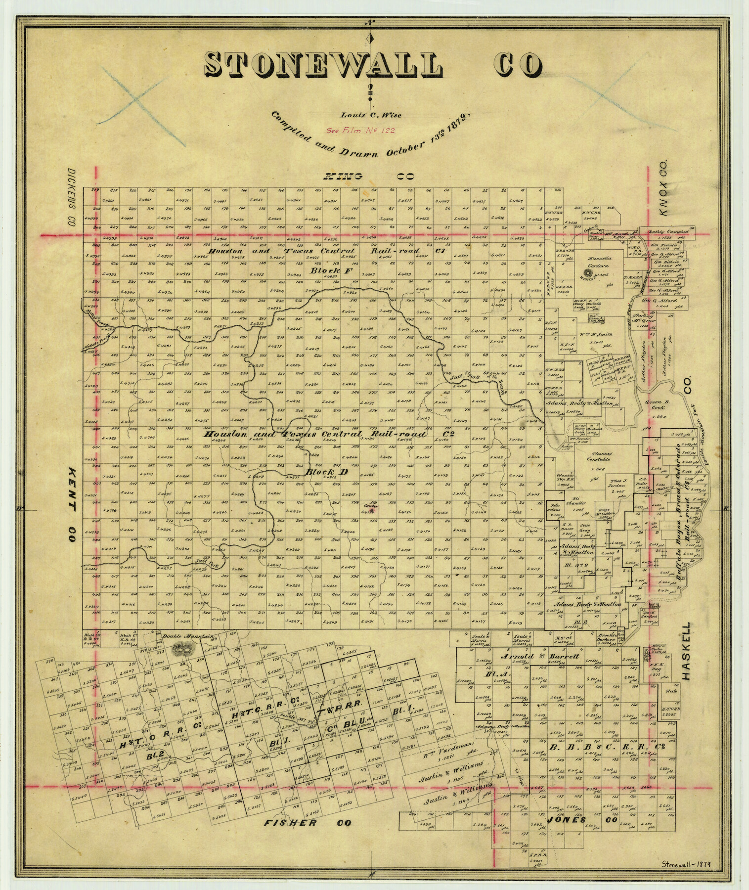
Stonewall County
-
Map/Doc
4058
-
Collection
General Map Collection
-
Object Dates
1879/10/13 (Creation Date)
-
People and Organizations
Texas General Land Office (Publisher)
Louis C. Wise (Draftsman)
Louis C. Wise (Compiler)
-
Counties
Stonewall
-
Subjects
County
-
Height x Width
22.7 x 19.1 inches
57.7 x 48.5 cm
-
Features
Croton Creek
Salt Fork of the Brazos River
Kiowa Peak
North Prong of the Brazos River
Middle Prong of the Brazos River
Double Mountain Fork [of the Brazos River]
Mulberry Creek
Double Mountain
Otey's Creek
South Prong of the Brazos River
Part of: General Map Collection
Jefferson County Sketch File 5

Print $50.00
- Digital $50.00
Jefferson County Sketch File 5
1859
Size 7.9 x 6.9 inches
Map/Doc 28103
Hidalgo County Rolled Sketch 13

Print $20.00
- Digital $50.00
Hidalgo County Rolled Sketch 13
1960
Size 19.0 x 31.4 inches
Map/Doc 6212
Hopkins County Working Sketch 1

Print $20.00
- Digital $50.00
Hopkins County Working Sketch 1
1951
Size 24.1 x 19.0 inches
Map/Doc 66226
Flight Mission No. CGI-3N, Frame 145, Cameron County

Print $20.00
- Digital $50.00
Flight Mission No. CGI-3N, Frame 145, Cameron County
1954
Size 18.6 x 22.3 inches
Map/Doc 84618
Brazoria County Sketch File 39

Print $8.00
- Digital $50.00
Brazoria County Sketch File 39
1933
Size 11.3 x 8.8 inches
Map/Doc 15045
Rusk County Rolled Sketch 7

Print $20.00
- Digital $50.00
Rusk County Rolled Sketch 7
Size 43.0 x 37.3 inches
Map/Doc 9876
Ochiltree County

Print $20.00
- Digital $50.00
Ochiltree County
1908
Size 40.9 x 37.1 inches
Map/Doc 16782
Armstrong County Sketch File 3

Print $40.00
- Digital $50.00
Armstrong County Sketch File 3
1883
Size 27.4 x 29.4 inches
Map/Doc 10839
Tyler County Rolled Sketch 6

Print $40.00
- Digital $50.00
Tyler County Rolled Sketch 6
1956
Size 76.1 x 43.2 inches
Map/Doc 10029
Texas Official Highway Travel Map

Digital $50.00
Texas Official Highway Travel Map
1975
Size 27.2 x 36.2 inches
Map/Doc 94312
Matagorda County Rolled Sketch 19

Print $20.00
- Digital $50.00
Matagorda County Rolled Sketch 19
1918
Size 13.0 x 16.6 inches
Map/Doc 6687
Lynn County Boundary File 1

Print $10.00
- Digital $50.00
Lynn County Boundary File 1
Size 14.2 x 8.7 inches
Map/Doc 56617
You may also like
Hamilton County Boundary File 3

Print $52.00
- Digital $50.00
Hamilton County Boundary File 3
Size 14.2 x 8.8 inches
Map/Doc 54197
Flight Mission No. BQR-4K, Frame 66, Brazoria County

Print $20.00
- Digital $50.00
Flight Mission No. BQR-4K, Frame 66, Brazoria County
1952
Size 18.8 x 22.5 inches
Map/Doc 83999
Erath County Working Sketch 50b

Print $20.00
- Digital $50.00
Erath County Working Sketch 50b
Size 43.4 x 25.8 inches
Map/Doc 69132
Coke County Rolled Sketch 9

Print $20.00
- Digital $50.00
Coke County Rolled Sketch 9
Size 25.7 x 20.7 inches
Map/Doc 5508
[Surveys along the Brazos River]
![71, [Surveys along the Brazos River], General Map Collection](https://historictexasmaps.com/wmedia_w700/maps/71.tif.jpg)
Print $3.00
- Digital $50.00
[Surveys along the Brazos River]
1840
Size 16.2 x 9.4 inches
Map/Doc 71
Hamilton County Working Sketch 21

Print $40.00
- Digital $50.00
Hamilton County Working Sketch 21
1955
Size 52.4 x 43.7 inches
Map/Doc 63359
Flight Mission No. BRA-8M, Frame 80, Jefferson County

Print $20.00
- Digital $50.00
Flight Mission No. BRA-8M, Frame 80, Jefferson County
1953
Size 15.9 x 15.6 inches
Map/Doc 85600
Sutton County Working Sketch 49

Print $20.00
- Digital $50.00
Sutton County Working Sketch 49
1955
Size 43.3 x 19.5 inches
Map/Doc 62392
Waller County Sketch File 1

Print $14.00
- Digital $50.00
Waller County Sketch File 1
Size 8.1 x 6.9 inches
Map/Doc 39563
Survey of Block L, University Lands, El Paso County, Texas

Print $40.00
- Digital $50.00
Survey of Block L, University Lands, El Paso County, Texas
1971
Size 43.4 x 71.6 inches
Map/Doc 2440
Map of the City of Aransas Pass

Print $20.00
- Digital $50.00
Map of the City of Aransas Pass
Size 24.0 x 26.2 inches
Map/Doc 6871
Township 12 South Range 14 West and 15 West, South Western District, Louisiana

Print $20.00
- Digital $50.00
Township 12 South Range 14 West and 15 West, South Western District, Louisiana
1838
Size 19.5 x 24.5 inches
Map/Doc 65856