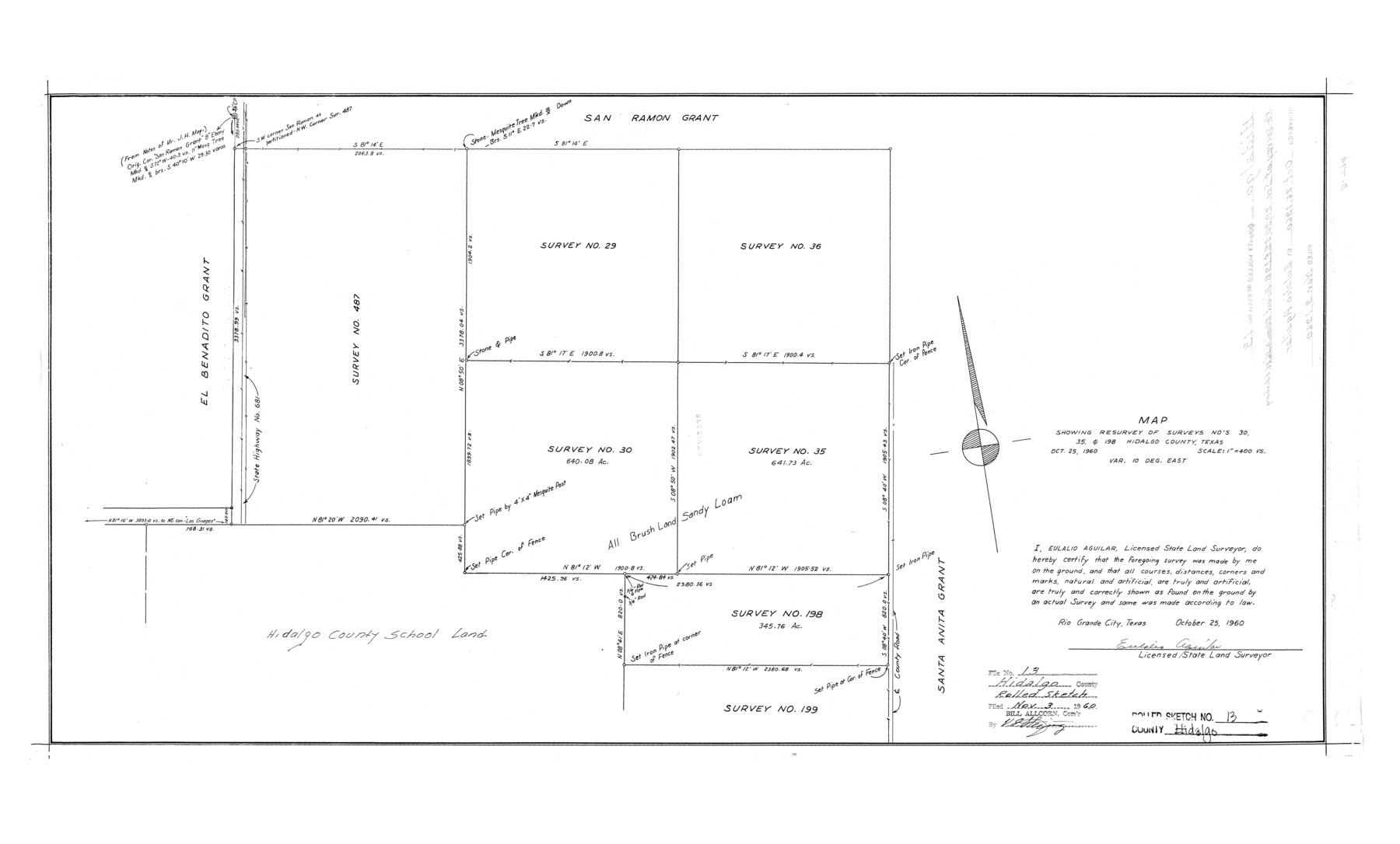
Hidalgo County Rolled Sketch 13
Map showing resurvey of surveys nos. 30, 35, & 198, Hidalgo County, Texas
-
Map/Doc
6212
-
Collection
General Map Collection
-
Object Dates
1960/10/25 (Creation Date)
1960/11/3 (File Date)
-
People and Organizations
Eulalio Aguilar (Surveyor/Engineer)
-
Counties
Hidalgo
-
Subjects
Surveying Rolled Sketch
-
Height x Width
19.0 x 31.4 inches
48.3 x 79.8 cm
-
Scale
1" = 400 varas
Part of: General Map Collection
San Jacinto County Sketch File 12a

Print $20.00
San Jacinto County Sketch File 12a
Size 12.8 x 14.3 inches
Map/Doc 35722
Briscoe County Sketch File 3

Print $40.00
- Digital $50.00
Briscoe County Sketch File 3
1885
Size 22.6 x 20.7 inches
Map/Doc 10992
[Atlas E, Table of Contents]
![78357, [Atlas E, Table of Contents], General Map Collection](https://historictexasmaps.com/wmedia_w700/maps/78357.tif.jpg)
Print $3.00
- Digital $50.00
[Atlas E, Table of Contents]
Size 17.8 x 11.0 inches
Map/Doc 78357
Flight Mission No. BRA-9M, Frame 71, Jefferson County

Print $20.00
- Digital $50.00
Flight Mission No. BRA-9M, Frame 71, Jefferson County
1953
Size 18.5 x 22.4 inches
Map/Doc 85654
Township 13 South Ranges 14 and 15 West, South Western District, Louisiana

Print $20.00
- Digital $50.00
Township 13 South Ranges 14 and 15 West, South Western District, Louisiana
1838
Size 19.6 x 24.8 inches
Map/Doc 65857
Briscoe County Rolled Sketch WL

Print $20.00
- Digital $50.00
Briscoe County Rolled Sketch WL
1936
Size 18.6 x 43.0 inches
Map/Doc 5335
Texas Prospectors and Historians Map

Digital $50.00
Texas Prospectors and Historians Map
Size 22.4 x 29.2 inches
Map/Doc 94411
Montgomery County Sketch File 41

Print $8.00
- Digital $50.00
Montgomery County Sketch File 41
2004
Size 14.0 x 8.5 inches
Map/Doc 82447
Stonewall County Boundary File 4a

Print $18.00
- Digital $50.00
Stonewall County Boundary File 4a
Size 14.2 x 8.8 inches
Map/Doc 58984
Kaufman County

Print $20.00
- Digital $50.00
Kaufman County
1942
Size 46.6 x 38.2 inches
Map/Doc 1871
Flight Mission No. CGI-3N, Frame 143, Cameron County

Print $20.00
- Digital $50.00
Flight Mission No. CGI-3N, Frame 143, Cameron County
1954
Size 18.5 x 22.1 inches
Map/Doc 84616
Webb County Rolled Sketch 33

Print $20.00
- Digital $50.00
Webb County Rolled Sketch 33
1939
Size 22.8 x 23.9 inches
Map/Doc 8189
You may also like
Kendall County Sketch File 26

Print $12.00
- Digital $50.00
Kendall County Sketch File 26
1950
Size 11.2 x 8.8 inches
Map/Doc 28725
Gillespie County Rolled Sketch 1

Print $20.00
- Digital $50.00
Gillespie County Rolled Sketch 1
1956
Size 19.7 x 36.1 inches
Map/Doc 6008
America siue India Nova ad magnae Gerardi Mercatoris aui Vniversalis imitationem in compendium redacta

Print $20.00
- Digital $50.00
America siue India Nova ad magnae Gerardi Mercatoris aui Vniversalis imitationem in compendium redacta
1585
Size 16.9 x 20.2 inches
Map/Doc 93808
Flight Mission No. BQR-12K, Frame 44, Brazoria County

Print $20.00
- Digital $50.00
Flight Mission No. BQR-12K, Frame 44, Brazoria County
1952
Size 18.8 x 22.4 inches
Map/Doc 84059
Pecos County Rolled Sketch 191

Print $20.00
- Digital $50.00
Pecos County Rolled Sketch 191
Size 18.2 x 27.4 inches
Map/Doc 95397
Brazos River Conservation and Reclamation District Official Boundary Line Survey, Parmer County

Print $20.00
- Digital $50.00
Brazos River Conservation and Reclamation District Official Boundary Line Survey, Parmer County
Size 24.9 x 36.9 inches
Map/Doc 91599
Angelina County Working Sketch 27

Print $40.00
- Digital $50.00
Angelina County Working Sketch 27
1954
Size 31.0 x 56.6 inches
Map/Doc 67109
United States - Gulf Coast - Galveston to Rio Grande

Print $20.00
- Digital $50.00
United States - Gulf Coast - Galveston to Rio Grande
1919
Size 27.2 x 18.2 inches
Map/Doc 72750
Uvalde County Rolled Sketch B

Print $20.00
- Digital $50.00
Uvalde County Rolled Sketch B
1847
Size 28.8 x 22.4 inches
Map/Doc 8105
Houston - Where Seventeen Railroads Meet the Sea

Houston - Where Seventeen Railroads Meet the Sea
1913
Size 6.1 x 8.2 inches
Map/Doc 97069
Map of Starr County
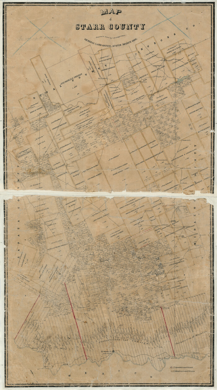
Print $20.00
- Digital $50.00
Map of Starr County
1880
Size 46.8 x 27.0 inches
Map/Doc 4044
Neches River, Box Creek Sheet Cross Section

Print $6.00
- Digital $50.00
Neches River, Box Creek Sheet Cross Section
1940
Size 37.0 x 18.8 inches
Map/Doc 65079