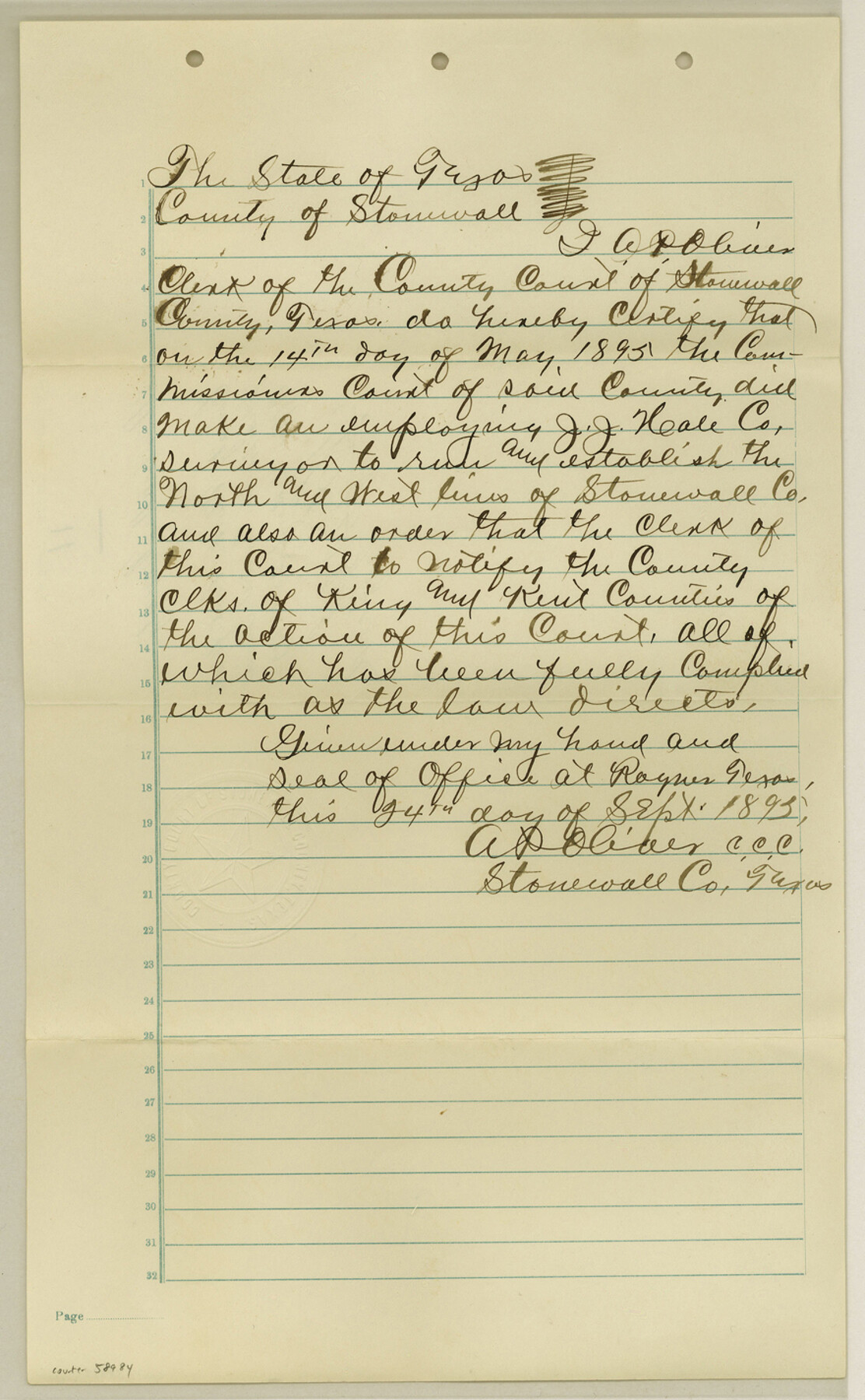
Stonewall County Boundary File 4a
Letter of explanation; Copy of the order of the County Commissioners Court; Surveyor's Certificate; County Clerk's Certificate
-
Map/Doc
58984
-
Collection
General Map Collection
-
Counties
Stonewall
-
Subjects
County Boundaries
-
Height x Width
14.2 x 8.8 inches
36.1 x 22.4 cm
Part of: General Map Collection

Yoakum County Sketch File 3

Print $54.00
- Digital $50.00
Yoakum County Sketch File 3
1892
Size 14.2 x 8.8 inches
Map/Doc 40705
Williamson County Working Sketch 19

Print $20.00
- Digital $50.00
Williamson County Working Sketch 19
1991
Size 31.2 x 40.0 inches
Map/Doc 72579
Pecos County Working Sketch 18

Print $20.00
- Digital $50.00
Pecos County Working Sketch 18
1917
Size 18.4 x 20.9 inches
Map/Doc 71488
Pecos County Working Sketch Graphic Index - south part

Print $20.00
- Digital $50.00
Pecos County Working Sketch Graphic Index - south part
1976
Size 35.3 x 43.2 inches
Map/Doc 76665
Location of the Southern Kansas Railway of Texas

Print $40.00
- Digital $50.00
Location of the Southern Kansas Railway of Texas
1887
Size 18.6 x 106.9 inches
Map/Doc 64181
Presidio County Sketch File 69b

Print $6.00
- Digital $50.00
Presidio County Sketch File 69b
1919
Size 11.2 x 8.8 inches
Map/Doc 34666
[Right of Way & Track Map, The Texas & Pacific Ry. Co. Main Line]
![64681, [Right of Way & Track Map, The Texas & Pacific Ry. Co. Main Line], General Map Collection](https://historictexasmaps.com/wmedia_w700/maps/64681.tif.jpg)
Print $20.00
- Digital $50.00
[Right of Way & Track Map, The Texas & Pacific Ry. Co. Main Line]
Size 11.0 x 19.0 inches
Map/Doc 64681
El Paso County Sketch File 26

Print $20.00
- Digital $50.00
El Paso County Sketch File 26
Size 24.8 x 21.9 inches
Map/Doc 11457
Goliad County Sketch File 23

Print $4.00
- Digital $50.00
Goliad County Sketch File 23
1877
Size 8.1 x 12.8 inches
Map/Doc 24295
Brewster County Sketch File C-1

Print $14.00
- Digital $50.00
Brewster County Sketch File C-1
1911
Size 11.2 x 8.9 inches
Map/Doc 15719
Map of Hill County

Print $40.00
- Digital $50.00
Map of Hill County
1884
Size 80.1 x 68.0 inches
Map/Doc 82049
You may also like
Briscoe County Rolled Sketch 6

Print $20.00
- Digital $50.00
Briscoe County Rolled Sketch 6
Size 27.0 x 31.4 inches
Map/Doc 5326
Presidio County Rolled Sketch 95

Print $20.00
- Digital $50.00
Presidio County Rolled Sketch 95
1949
Size 45.4 x 37.5 inches
Map/Doc 9781
Goliad County Working Sketch 20

Print $20.00
- Digital $50.00
Goliad County Working Sketch 20
1955
Size 31.4 x 22.8 inches
Map/Doc 63210
[Blocks P, D, and John H. Gibson]
![90446, [Blocks P, D, and John H. Gibson], Twichell Survey Records](https://historictexasmaps.com/wmedia_w700/maps/90446-2.tif.jpg)
Print $20.00
- Digital $50.00
[Blocks P, D, and John H. Gibson]
Size 28.2 x 19.5 inches
Map/Doc 90446
Flight Mission No. BQR-13K, Frame 119, Brazoria County

Print $20.00
- Digital $50.00
Flight Mission No. BQR-13K, Frame 119, Brazoria County
1952
Size 19.0 x 22.6 inches
Map/Doc 84080
Map Showing Location of Dallas & Greenville Railroad through Rockwall County, Texas

Print $3.00
- Digital $50.00
Map Showing Location of Dallas & Greenville Railroad through Rockwall County, Texas
Size 7.9 x 17.5 inches
Map/Doc 64485
Chambers County Sketch File 18

Print $40.00
- Digital $50.00
Chambers County Sketch File 18
1879
Size 24.6 x 8.1 inches
Map/Doc 17569
Floyd County Sketch File 7

Print $4.00
- Digital $50.00
Floyd County Sketch File 7
Size 8.9 x 14.3 inches
Map/Doc 22697
Map of Schleicher Co.

Print $20.00
- Digital $50.00
Map of Schleicher Co.
1891
Size 24.4 x 32.5 inches
Map/Doc 63024
Lamb County Sketch File 11

Print $6.00
- Digital $50.00
Lamb County Sketch File 11
1913
Size 11.5 x 8.8 inches
Map/Doc 29360
Les costes aux environs de la Riviere de Misisipi decouvertes par M. de la Salle en 1683 et reconnues par M. le Chevallier d'Iberville en 1698 et 1699

Print $20.00
- Digital $50.00
Les costes aux environs de la Riviere de Misisipi decouvertes par M. de la Salle en 1683 et reconnues par M. le Chevallier d'Iberville en 1698 et 1699
1701
Size 10.4 x 14.9 inches
Map/Doc 93756
Pecos County Working Sketch 100

Print $20.00
- Digital $50.00
Pecos County Working Sketch 100
1970
Size 42.9 x 31.6 inches
Map/Doc 71573