Presidio County Sketch File 69b
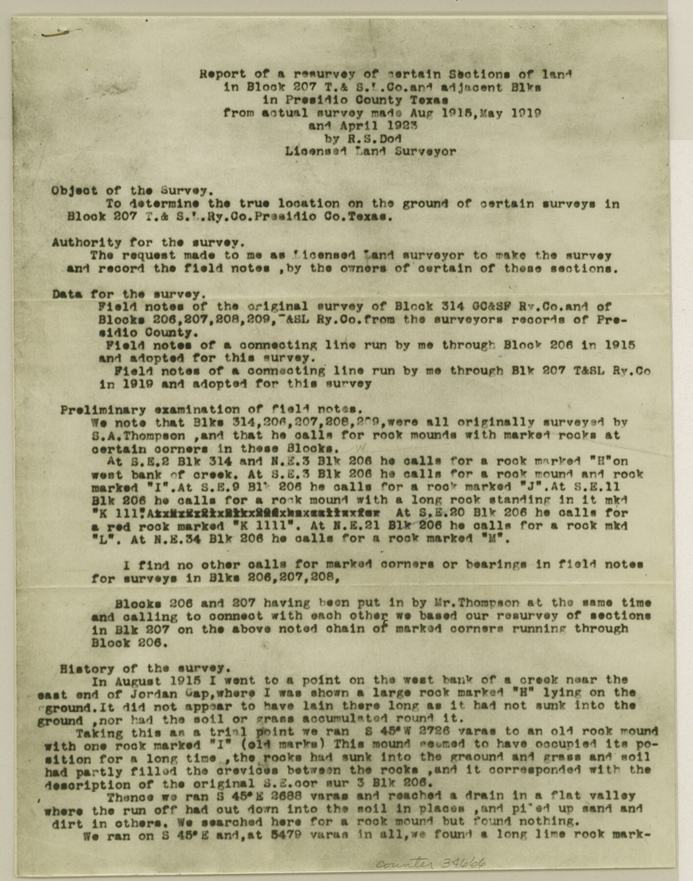
[Report of a resurvey of certain sections of land in Block 207, T. & St. L. Co. and adjacent Blocks]
-
Map/Doc
34666
-
Collection
General Map Collection
-
Object Dates
8/1919 (Creation Date)
4/30/1942 (File Date)
8/1915 (Survey Date)
5/1919 (Survey Date)
4/1923 (Survey Date)
5/1919 (Survey Date)
-
People and Organizations
R.S. Dod (Surveyor/Engineer)
S.A. Thompson (Surveyor/Engineer)
-
Counties
Presidio
-
Subjects
Surveying Sketch File
-
Height x Width
11.2 x 8.8 inches
28.5 x 22.4 cm
-
Medium
photostat
-
Comments
See Presidio County Sketch File 69a (34664) for sketch.
-
Features
Jordan Gap
Puerta Potrillo
Related maps
Presidio County Sketch File 69a

Print $6.00
- Digital $50.00
Presidio County Sketch File 69a
1923
Size 17.0 x 11.0 inches
Map/Doc 34664
Part of: General Map Collection
Nueces County NRC Article 33.136 Sketch 4

Print $50.00
- Digital $50.00
Nueces County NRC Article 33.136 Sketch 4
2001
Size 17.7 x 24.1 inches
Map/Doc 7167
Trinity County Working Sketch 7b

Print $20.00
- Digital $50.00
Trinity County Working Sketch 7b
1939
Size 27.4 x 24.7 inches
Map/Doc 69456
Presidio County Sketch File 59

Print $12.00
- Digital $50.00
Presidio County Sketch File 59
1935
Size 8.7 x 7.5 inches
Map/Doc 34637

Brewster County Rolled Sketch 67

Print $20.00
- Digital $50.00
Brewster County Rolled Sketch 67
1940
Size 32.0 x 23.5 inches
Map/Doc 5233
Wheeler County Working Sketch 15

Print $20.00
- Digital $50.00
Wheeler County Working Sketch 15
1981
Size 27.9 x 29.3 inches
Map/Doc 72504
Map from Corpus Christi to Matagorda Bays, Texas [Inset: Survey of the channel of Copono Bay]
![72976, Map from Corpus Christi to Matagorda Bays, Texas [Inset: Survey of the channel of Copono Bay], General Map Collection](https://historictexasmaps.com/wmedia_w700/maps/72976.tif.jpg)
Print $20.00
- Digital $50.00
Map from Corpus Christi to Matagorda Bays, Texas [Inset: Survey of the channel of Copono Bay]
1846
Size 18.1 x 27.5 inches
Map/Doc 72976
Pecos County Working Sketch 92

Print $40.00
- Digital $50.00
Pecos County Working Sketch 92
1966
Size 31.4 x 62.2 inches
Map/Doc 71565
[Map of Chicago, Rock Island & Texas Railway through Tarrant County, Texas]
![64413, [Map of Chicago, Rock Island & Texas Railway through Tarrant County, Texas], General Map Collection](https://historictexasmaps.com/wmedia_w700/maps/64413.tif.jpg)
Print $40.00
- Digital $50.00
[Map of Chicago, Rock Island & Texas Railway through Tarrant County, Texas]
1893
Size 22.3 x 121.8 inches
Map/Doc 64413
Flight Mission No. DIX-8P, Frame 67, Aransas County

Print $20.00
- Digital $50.00
Flight Mission No. DIX-8P, Frame 67, Aransas County
1956
Size 18.7 x 22.4 inches
Map/Doc 83898
Midland County Working Sketch 12

Print $20.00
- Digital $50.00
Midland County Working Sketch 12
1951
Size 23.1 x 19.0 inches
Map/Doc 70992
Gaines County Working Sketch 37

Print $20.00
- Digital $50.00
Gaines County Working Sketch 37
Size 21.5 x 16.6 inches
Map/Doc 69337
You may also like
Tom Green County Rolled Sketch 14

Print $20.00
- Digital $50.00
Tom Green County Rolled Sketch 14
1953
Size 26.7 x 28.4 inches
Map/Doc 8000
Flight Mission No. CRC-2R, Frame 191, Chambers County

Print $20.00
- Digital $50.00
Flight Mission No. CRC-2R, Frame 191, Chambers County
1956
Size 18.6 x 22.4 inches
Map/Doc 84769
Right-of-Way and Track Map, Texas State Railroad operated by the T. and N. O. R.R. Co.

Print $40.00
- Digital $50.00
Right-of-Way and Track Map, Texas State Railroad operated by the T. and N. O. R.R. Co.
1918
Size 24.5 x 56.1 inches
Map/Doc 64178
Flight Mission No. CRE-2R, Frame 164, Jackson County

Print $20.00
- Digital $50.00
Flight Mission No. CRE-2R, Frame 164, Jackson County
1956
Size 18.5 x 22.2 inches
Map/Doc 85374

Nueces County Sketch File 36

Print $20.00
- Digital $50.00
Nueces County Sketch File 36
1913
Size 17.0 x 18.4 inches
Map/Doc 42189
Stonewall County Working Sketch 23

Print $20.00
- Digital $50.00
Stonewall County Working Sketch 23
1967
Size 23.4 x 26.1 inches
Map/Doc 62330
Schleicher County Working Sketch 16

Print $20.00
- Digital $50.00
Schleicher County Working Sketch 16
1942
Size 24.5 x 26.4 inches
Map/Doc 63818
Harris County NRC Article 33.136 Sketch 13

Print $28.00
- Digital $50.00
Harris County NRC Article 33.136 Sketch 13
2009
Size 36.0 x 24.3 inches
Map/Doc 94641
Nueces County Rolled Sketch 50

Print $20.00
- Digital $50.00
Nueces County Rolled Sketch 50
1939
Size 21.9 x 38.0 inches
Map/Doc 9605
Upton County Working Sketch 26

Print $20.00
- Digital $50.00
Upton County Working Sketch 26
1953
Size 29.5 x 17.6 inches
Map/Doc 69522
Sutton County Sketch File E2

Print $20.00
- Digital $50.00
Sutton County Sketch File E2
Size 16.8 x 19.0 inches
Map/Doc 12397