Presidio County Sketch File 69a
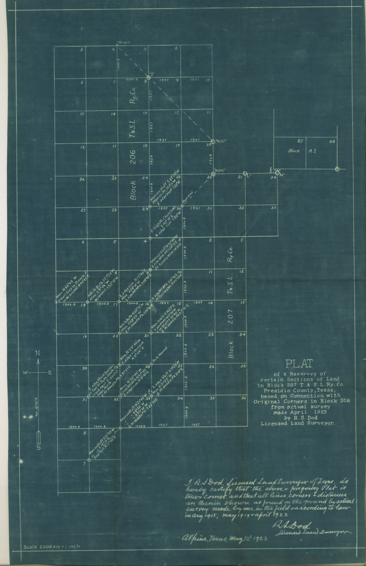
Plat of a resurvey of certain sections of land in Block 207, T. & St. L. RR. Co. based on connection with original corners in Block 206
-
Map/Doc
34664
-
Collection
General Map Collection
-
Object Dates
4/1923 (Creation Date)
4/30/1942 (File Date)
4/1923 (Survey Date)
8/1915 (Survey Date)
5/1919 (Survey Date)
5/12/1923 (Creation Date)
-
People and Organizations
R.S. Dod (Surveyor/Engineer)
-
Counties
Presidio Brewster
-
Subjects
Surveying Sketch File
-
Height x Width
17.0 x 11.0 inches
43.2 x 27.9 cm
-
Medium
blueprint/diazo
-
Scale
1" = 2000 varas
-
Comments
See Presidio County Sketch File 69b (34666) for report.
-
Features
Needle Peak
Red Hill
Related maps
Presidio County Sketch File 69b

Print $6.00
- Digital $50.00
Presidio County Sketch File 69b
1919
Size 11.2 x 8.8 inches
Map/Doc 34666
Part of: General Map Collection
Rusk County Working Sketch 13

Print $20.00
- Digital $50.00
Rusk County Working Sketch 13
1976
Size 33.2 x 39.1 inches
Map/Doc 63648
Harrisburg, Texas

Print $20.00
- Digital $50.00
Harrisburg, Texas
1854
Size 39.4 x 25.7 inches
Map/Doc 3044
Garza County Sketch File D

Print $20.00
- Digital $50.00
Garza County Sketch File D
1901
Size 18.4 x 12.2 inches
Map/Doc 11550
Victoria County Working Sketch 10

Print $20.00
- Digital $50.00
Victoria County Working Sketch 10
1964
Size 36.9 x 45.4 inches
Map/Doc 72280
Sutton County Working Sketch 56

Print $20.00
- Digital $50.00
Sutton County Working Sketch 56
1958
Size 27.6 x 28.8 inches
Map/Doc 62399
Kleberg County Rolled Sketch 10-34

Print $20.00
- Digital $50.00
Kleberg County Rolled Sketch 10-34
1952
Size 38.2 x 32.3 inches
Map/Doc 9384
Denton County Sketch File 43

Print $20.00
- Digital $50.00
Denton County Sketch File 43
2006
Size 11.0 x 8.5 inches
Map/Doc 83610
Real County Rolled Sketch 13

Print $20.00
- Digital $50.00
Real County Rolled Sketch 13
Size 23.0 x 34.0 inches
Map/Doc 9838
Outer Continental Shelf Leasing Maps (Louisiana Offshore Operations)

Print $20.00
- Digital $50.00
Outer Continental Shelf Leasing Maps (Louisiana Offshore Operations)
1959
Size 17.8 x 14.0 inches
Map/Doc 76106

Brazoria County Sketch File 1

Print $4.00
- Digital $50.00
Brazoria County Sketch File 1
1861
Size 9.7 x 8.3 inches
Map/Doc 14916
Maps of Gulf Intracoastal Waterway, Texas - Sabine River to the Rio Grande and connecting waterways including ship channels

Print $20.00
- Digital $50.00
Maps of Gulf Intracoastal Waterway, Texas - Sabine River to the Rio Grande and connecting waterways including ship channels
1966
Size 14.6 x 22.3 inches
Map/Doc 61962
You may also like

Foard County Aerial Photograph Index Sheet 4

Print $20.00
- Digital $50.00
Foard County Aerial Photograph Index Sheet 4
1950
Size 18.6 x 16.3 inches
Map/Doc 83691
Waller County Working Sketch 3

Print $20.00
- Digital $50.00
Waller County Working Sketch 3
1959
Size 35.4 x 28.8 inches
Map/Doc 72302
Flight Mission No. CUG-2P, Frame 10, Kleberg County

Print $20.00
- Digital $50.00
Flight Mission No. CUG-2P, Frame 10, Kleberg County
1956
Size 18.7 x 22.3 inches
Map/Doc 86182
Gaines County Sketch File 13

Print $40.00
- Digital $50.00
Gaines County Sketch File 13
1954
Size 8.9 x 20.4 inches
Map/Doc 23200
Hartley County

Print $20.00
- Digital $50.00
Hartley County
1891
Size 25.9 x 27.8 inches
Map/Doc 3639
Childress County Rolled Sketch 8

Print $20.00
- Digital $50.00
Childress County Rolled Sketch 8
1889
Size 12.4 x 22.2 inches
Map/Doc 5442
Flight Mission No. BQR-12K, Frame 48, Brazoria County

Print $20.00
- Digital $50.00
Flight Mission No. BQR-12K, Frame 48, Brazoria County
1952
Size 19.0 x 22.7 inches
Map/Doc 84063
Archer County Sketch File B

Print $18.00
- Digital $50.00
Archer County Sketch File B
1892
Size 14.2 x 8.8 inches
Map/Doc 13566
Bell County Sketch File 33

Print $6.00
- Digital $50.00
Bell County Sketch File 33
Size 14.4 x 8.7 inches
Map/Doc 14452
Concho County Sketch File 46

Print $24.00
- Digital $50.00
Concho County Sketch File 46
1961
Size 14.2 x 8.6 inches
Map/Doc 19213
Crockett County Rolled Sketch 65

Print $20.00
- Digital $50.00
Crockett County Rolled Sketch 65
1948
Size 13.4 x 27.5 inches
Map/Doc 5608