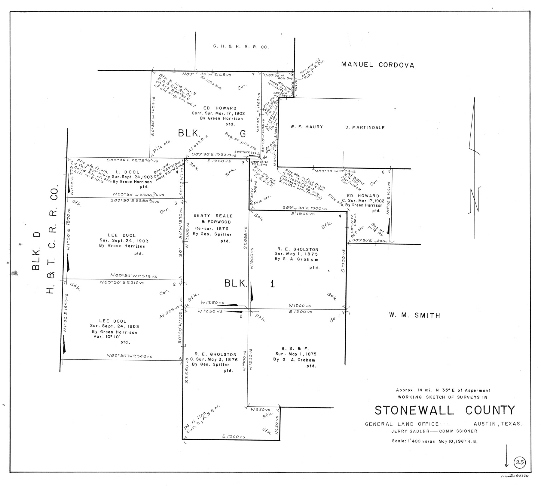
Stonewall County Working Sketch 23
-
Map/Doc
62330
-
Collection
General Map Collection
-
Object Dates
5/10/1967 (Creation Date)
-
People and Organizations
Roy Buckholts (Draftsman)
-
Counties
Stonewall
-
Subjects
Surveying Working Sketch
-
Height x Width
23.4 x 26.1 inches
59.4 x 66.3 cm
-
Scale
1" = 400 varas
Part of: General Map Collection
Fractional Township No. 10 South Range No. 27 East of the Indian Meridian, Indian Territory

Print $20.00
- Digital $50.00
Fractional Township No. 10 South Range No. 27 East of the Indian Meridian, Indian Territory
1897
Size 19.2 x 24.3 inches
Map/Doc 75246
Flight Mission No. DAH-17M, Frame 27, Orange County

Print $20.00
- Digital $50.00
Flight Mission No. DAH-17M, Frame 27, Orange County
1953
Size 18.6 x 22.3 inches
Map/Doc 86890
Angelina County Sketch File 15g

Print $4.00
- Digital $50.00
Angelina County Sketch File 15g
1882
Size 10.9 x 8.4 inches
Map/Doc 12996
Zavala County Boundary File 2

Print $36.00
- Digital $50.00
Zavala County Boundary File 2
Size 9.2 x 4.3 inches
Map/Doc 60239
Brown County Sketch File 24

Print $6.00
- Digital $50.00
Brown County Sketch File 24
1889
Size 11.7 x 15.9 inches
Map/Doc 11022
Map of Lavaca County

Print $20.00
- Digital $50.00
Map of Lavaca County
1853
Size 20.1 x 20.4 inches
Map/Doc 3801
Frio County Sketch File 16

Print $8.00
- Digital $50.00
Frio County Sketch File 16
1949
Size 11.3 x 8.8 inches
Map/Doc 23148
Harris County Boundary File 39 (17)

Print $4.00
- Digital $50.00
Harris County Boundary File 39 (17)
Size 10.0 x 8.1 inches
Map/Doc 54357
Crane County Working Sketch 11

Print $20.00
- Digital $50.00
Crane County Working Sketch 11
1941
Size 18.8 x 18.4 inches
Map/Doc 68288
Bexar County Sketch File 60

Print $4.00
- Digital $50.00
Bexar County Sketch File 60
2009
Size 11.0 x 8.5 inches
Map/Doc 93669
Eastland County Sketch File A

Print $20.00
- Digital $50.00
Eastland County Sketch File A
1887
Size 18.1 x 16.8 inches
Map/Doc 11413
Kerr County Rolled Sketch 11A

Print $20.00
- Digital $50.00
Kerr County Rolled Sketch 11A
1950
Size 27.8 x 36.0 inches
Map/Doc 6496
You may also like
Kimble County Working Sketch 3

Print $20.00
- Digital $50.00
Kimble County Working Sketch 3
1897
Size 16.4 x 21.4 inches
Map/Doc 70071
Sketch Showing Division Fence Shelton- Matador, Oldham County, Texas

Print $20.00
- Digital $50.00
Sketch Showing Division Fence Shelton- Matador, Oldham County, Texas
Size 21.2 x 23.0 inches
Map/Doc 91427
The New Naval and Military Map of the United States

Print $40.00
The New Naval and Military Map of the United States
Size 68.5 x 68.5 inches
Map/Doc 95309
[E. T. Ry. Blk. 1]
![89794, [E. T. Ry. Blk. 1], Twichell Survey Records](https://historictexasmaps.com/wmedia_w700/maps/89794-1.tif.jpg)
Print $40.00
- Digital $50.00
[E. T. Ry. Blk. 1]
Size 56.5 x 43.4 inches
Map/Doc 89794
Aransas Pass to Baffin Bay

Print $20.00
- Digital $50.00
Aransas Pass to Baffin Bay
1922
Size 18.5 x 27.2 inches
Map/Doc 73408
Cottle County Sketch File A and B

Print $27.00
- Digital $50.00
Cottle County Sketch File A and B
Size 18.4 x 24.1 inches
Map/Doc 11200
General Highway Map, Hardeman County, Texas

Print $20.00
General Highway Map, Hardeman County, Texas
1940
Size 25.0 x 18.3 inches
Map/Doc 79113
[Sketch showing surveys in Blocks 70, 71 and 72 surrounding the town of Toyah]
![91750, [Sketch showing surveys in Blocks 70, 71 and 72 surrounding the town of Toyah], Twichell Survey Records](https://historictexasmaps.com/wmedia_w700/maps/91750-1.tif.jpg)
Print $20.00
- Digital $50.00
[Sketch showing surveys in Blocks 70, 71 and 72 surrounding the town of Toyah]
Size 44.9 x 26.1 inches
Map/Doc 91750
Jasper County Working Sketch 20

Print $20.00
- Digital $50.00
Jasper County Working Sketch 20
1940
Size 27.2 x 45.0 inches
Map/Doc 66482
Oldham School Land, Cochran County

Print $20.00
- Digital $50.00
Oldham School Land, Cochran County
Size 13.4 x 21.8 inches
Map/Doc 90302
The Republic County of Gonzales. December 18, 1837

Print $20.00
The Republic County of Gonzales. December 18, 1837
2020
Size 14.7 x 21.7 inches
Map/Doc 96154
Surveys on the lines [?] of Plum Creek
![78384, Surveys on the lines [?] of Plum Creek, General Map Collection](https://historictexasmaps.com/wmedia_w700/maps/78384.tif.jpg)
Print $2.00
- Digital $50.00
Surveys on the lines [?] of Plum Creek
Size 10.5 x 8.4 inches
Map/Doc 78384