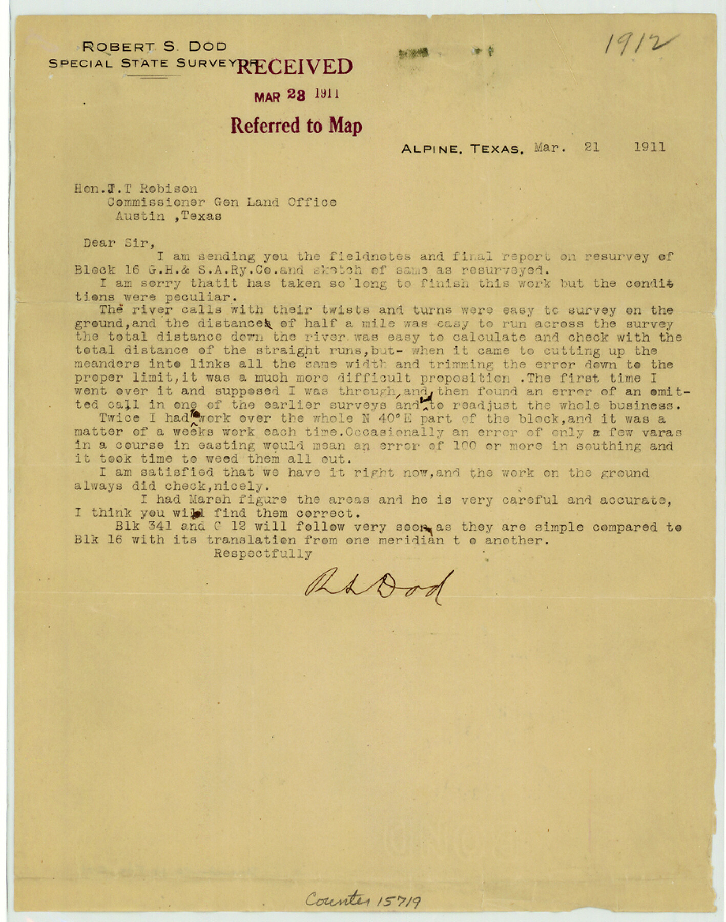
Brewster County Sketch File C-1
Report on resurvey of Block 16, G. H. & S. A. Ry. Co., Brewster County, Texas
-
Map/Doc
15719
-
Collection
General Map Collection
-
Object Dates
1911/3/20 (Creation Date)
1911/3/23 (File Date)
-
People and Organizations
R.S. Dod (Surveyor/Engineer)
-
Counties
Brewster
-
Subjects
Surveying Sketch File
-
Height x Width
11.2 x 8.9 inches
28.4 x 22.6 cm
-
Medium
paper, print
-
Comments
See Brewster County Sketch File C (10976) for sketch.
-
Features
Rio Grande
Grand Canyon
Mule Ear Peaks
Blue Creek
Related maps
Brewster County Sketch File C

Print $40.00
- Digital $50.00
Brewster County Sketch File C
1911
Size 18.6 x 26.6 inches
Map/Doc 10976
Part of: General Map Collection
[Map of Encinal County]
![3517, [Map of Encinal County], General Map Collection](https://historictexasmaps.com/wmedia_w700/maps/3517-1.tif.jpg)
Print $20.00
- Digital $50.00
[Map of Encinal County]
1872
Size 27.9 x 21.9 inches
Map/Doc 3517
Flight Mission No. CUG-1P, Frame 46, Kleberg County

Print $20.00
- Digital $50.00
Flight Mission No. CUG-1P, Frame 46, Kleberg County
1956
Size 18.6 x 22.2 inches
Map/Doc 86124
Rusk County Sketch File 19

Print $4.00
Rusk County Sketch File 19
Size 13.0 x 8.2 inches
Map/Doc 35526
Pecos County Working Sketch 38

Print $20.00
- Digital $50.00
Pecos County Working Sketch 38
1939
Size 29.5 x 42.7 inches
Map/Doc 71510
Flight Mission No. CRC-2R, Frame 184, Chambers County

Print $20.00
- Digital $50.00
Flight Mission No. CRC-2R, Frame 184, Chambers County
1956
Size 18.6 x 22.2 inches
Map/Doc 84762
Dickens County

Print $20.00
- Digital $50.00
Dickens County
1895
Size 22.8 x 18.7 inches
Map/Doc 3484
Flight Mission No. DAG-21K, Frame 127, Matagorda County

Print $20.00
- Digital $50.00
Flight Mission No. DAG-21K, Frame 127, Matagorda County
1952
Size 18.5 x 22.4 inches
Map/Doc 86453
Sutton County Sketch File 1

Print $6.00
- Digital $50.00
Sutton County Sketch File 1
1885
Size 14.3 x 8.9 inches
Map/Doc 37348
Austin County Rolled Sketch 6

Print $20.00
- Digital $50.00
Austin County Rolled Sketch 6
1951
Size 25.5 x 34.0 inches
Map/Doc 5108
Map of Upshur County Texas

Print $20.00
- Digital $50.00
Map of Upshur County Texas
1873
Size 20.4 x 15.2 inches
Map/Doc 4635
Rio Grande, La Grulla Sheet

Print $20.00
- Digital $50.00
Rio Grande, La Grulla Sheet
1931
Size 28.2 x 49.0 inches
Map/Doc 65107
Morris County Rolled Sketch 2A

Print $20.00
- Digital $50.00
Morris County Rolled Sketch 2A
Size 24.5 x 19.4 inches
Map/Doc 10248
You may also like
Galveston Entrance, Texas From a Trigonometrical Survey Under the direction of A.D. Bache Superintendent of the Survey of the Coast of the United States

Print $20.00
- Digital $50.00
Galveston Entrance, Texas From a Trigonometrical Survey Under the direction of A.D. Bache Superintendent of the Survey of the Coast of the United States
1853
Size 15.9 x 19.3 inches
Map/Doc 93998
Parker County Sketch File 18

Print $4.00
- Digital $50.00
Parker County Sketch File 18
1876
Size 8.9 x 6.3 inches
Map/Doc 33554
Galveston County Sketch File 69

Print $226.00
- Digital $50.00
Galveston County Sketch File 69
1884
Size 14.4 x 9.0 inches
Map/Doc 23815
Cooke County Sketch File 35a

Print $4.00
- Digital $50.00
Cooke County Sketch File 35a
1879
Size 8.9 x 8.6 inches
Map/Doc 19302
Jeff Davis County Rolled Sketch 20

Print $20.00
- Digital $50.00
Jeff Davis County Rolled Sketch 20
1944
Size 22.7 x 19.6 inches
Map/Doc 7724
United States - Gulf Coast - Padre I. and Laguna Madre Lat. 27° 12' to Lat. 26° 33' Texas

Print $20.00
- Digital $50.00
United States - Gulf Coast - Padre I. and Laguna Madre Lat. 27° 12' to Lat. 26° 33' Texas
1913
Size 27.0 x 18.2 inches
Map/Doc 72813
Myrick Farms Lubbock & Hockley Counties

Print $20.00
- Digital $50.00
Myrick Farms Lubbock & Hockley Counties
Size 21.3 x 21.5 inches
Map/Doc 92830
[FT. W. & R. G. Ry. Right of Way Map, Winchell to Brady, McCulloch County, Texas]
![61411, [FT. W. & R. G. Ry. Right of Way Map, Winchell to Brady, McCulloch County, Texas], General Map Collection](https://historictexasmaps.com/wmedia_w700/maps/61411.tif.jpg)
Print $20.00
- Digital $50.00
[FT. W. & R. G. Ry. Right of Way Map, Winchell to Brady, McCulloch County, Texas]
1918
Size 37.0 x 26.9 inches
Map/Doc 61411
Martin County Sketch File 16

Print $2.00
- Digital $50.00
Martin County Sketch File 16
1996
Size 11.2 x 8.8 inches
Map/Doc 30676
Flight Mission No. DAH-9M, Frame 198, Orange County

Print $20.00
- Digital $50.00
Flight Mission No. DAH-9M, Frame 198, Orange County
1953
Size 18.6 x 22.5 inches
Map/Doc 86866
Sketch Showing Construction of School Leagues and Adjacent Lands Situated in Martin and Dawson Counties

Print $40.00
- Digital $50.00
Sketch Showing Construction of School Leagues and Adjacent Lands Situated in Martin and Dawson Counties
1914
Size 39.3 x 97.6 inches
Map/Doc 93201
Photo Index of Texas Coast - Sheet 2 of 6

Print $20.00
- Digital $50.00
Photo Index of Texas Coast - Sheet 2 of 6
1954
Size 20.0 x 24.0 inches
Map/Doc 83439