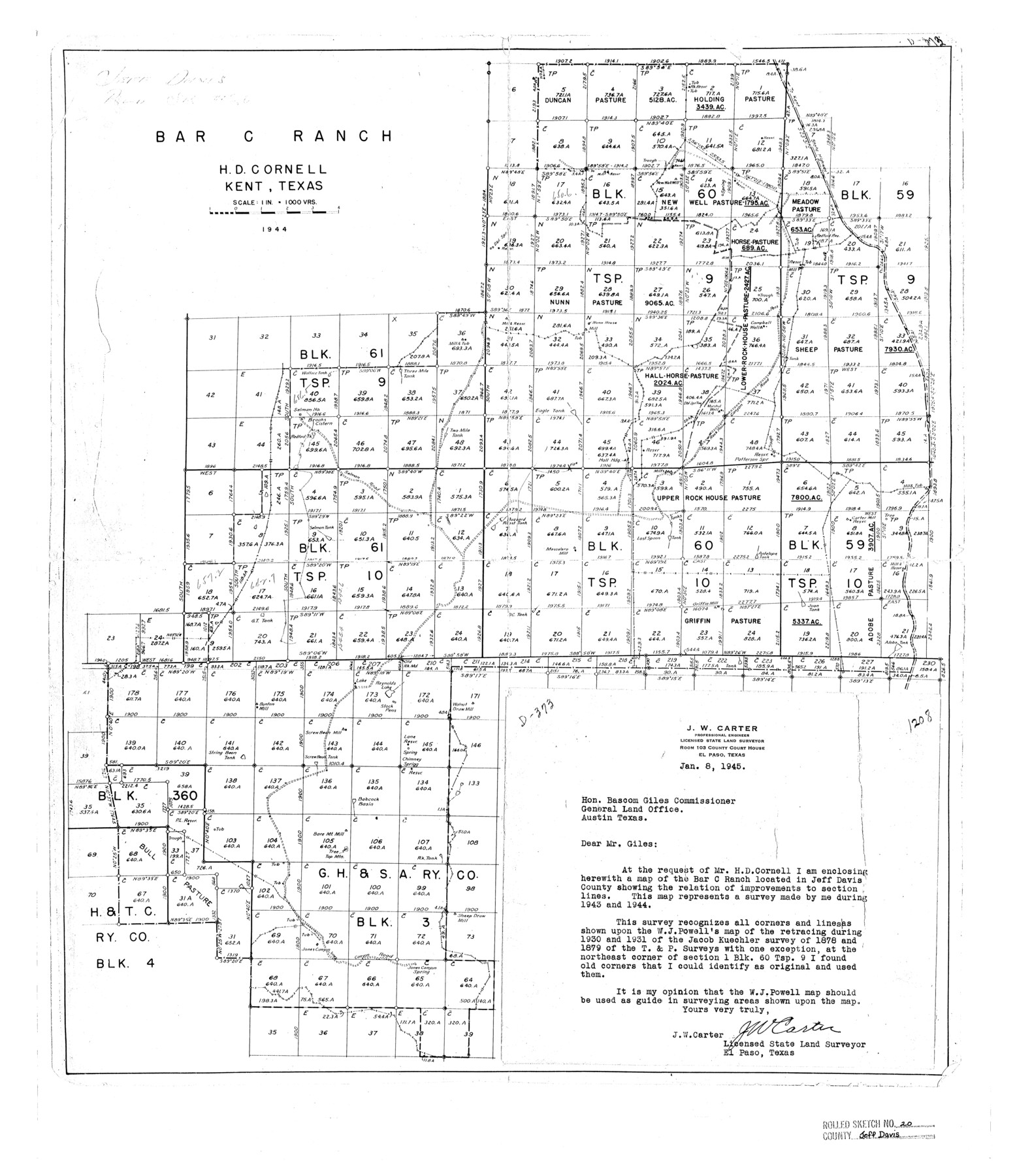
Jeff Davis County Rolled Sketch 20
Bar C Ranch, H.D. Cornell, Kent, Texas
-
Map/Doc
7724
-
Collection
General Map Collection
-
Object Dates
1944 (Creation Date)
1945/9/24 (File Date)
-
People and Organizations
J.W. Carter (Surveyor/Engineer)
-
Counties
Jeff Davis
-
Subjects
Cadastral Surveying Rolled Sketch
-
Height x Width
22.7 x 19.6 inches
57.7 x 49.8 cm
-
Scale
1" = 1000 varas
Part of: General Map Collection
Supreme Court of the United States, October Term, 1923, No. 15, Original - The State of Oklahoma, Complainant vs. The State of Texas, Defendant, The United States, Intervener; Report of the Boundary Commissioners
![3058, Supreme Court of the United States, October Term, 1923, No. 15, Original - The State of Oklahoma, Complainant vs. The State of Texas, Defendant, The United States, Intervener; Report of the Boundary Commissioners, General Map Collection](https://historictexasmaps.com/wmedia_w700/pdf_converted_jpg/qi_pdf_thumbnail_1297.jpg)
Print $98.00
- Digital $50.00
Supreme Court of the United States, October Term, 1923, No. 15, Original - The State of Oklahoma, Complainant vs. The State of Texas, Defendant, The United States, Intervener; Report of the Boundary Commissioners
1924
Size 6.1 x 9.2 inches
Map/Doc 3058
Colorado County Sketch File 24
![11137, Colorado County Sketch File 24, General Map Collection](https://historictexasmaps.com/wmedia_w700/pdf_converted_jpg/qi_pdf_thumbnail_7671.jpg)
Print $20.00
- Digital $50.00
Colorado County Sketch File 24
Size 22.7 x 16.6 inches
Map/Doc 11137
Schleicher County Rolled Sketch 27
![9909, Schleicher County Rolled Sketch 27, General Map Collection](https://historictexasmaps.com/wmedia_w700/maps/9909.tif.jpg)
Print $20.00
- Digital $50.00
Schleicher County Rolled Sketch 27
Size 37.4 x 43.3 inches
Map/Doc 9909
El Paso County Rolled Sketch 52
![5848, El Paso County Rolled Sketch 52, General Map Collection](https://historictexasmaps.com/wmedia_w700/maps/5848-1.tif.jpg)
Print $20.00
- Digital $50.00
El Paso County Rolled Sketch 52
1929
Size 18.5 x 24.4 inches
Map/Doc 5848
Right of Way and Track Map, Dayton-Goose Creek Ry. Co., Station 0+00 to Station 190+00
![64365, Right of Way and Track Map, Dayton-Goose Creek Ry. Co., Station 0+00 to Station 190+00, General Map Collection](https://historictexasmaps.com/wmedia_w700/maps/64365.tif.jpg)
Print $40.00
- Digital $50.00
Right of Way and Track Map, Dayton-Goose Creek Ry. Co., Station 0+00 to Station 190+00
1917
Size 24.8 x 56.6 inches
Map/Doc 64365
Guadalupe County Working Sketch 6
![63315, Guadalupe County Working Sketch 6, General Map Collection](https://historictexasmaps.com/wmedia_w700/maps/63315.tif.jpg)
Print $20.00
- Digital $50.00
Guadalupe County Working Sketch 6
Size 24.0 x 19.7 inches
Map/Doc 63315
McLennan County Sketch File 7a
![31246, McLennan County Sketch File 7a, General Map Collection](https://historictexasmaps.com/wmedia_w700/pdf_converted_jpg/qi_pdf_thumbnail_12972.jpg)
Print $4.00
- Digital $50.00
McLennan County Sketch File 7a
1850
Size 10.3 x 7.4 inches
Map/Doc 31246
Kaufman County Sketch File 19
![28666, Kaufman County Sketch File 19, General Map Collection](https://historictexasmaps.com/wmedia_w700/pdf_converted_jpg/qi_pdf_thumbnail_12384.jpg)
Print $30.00
- Digital $50.00
Kaufman County Sketch File 19
1922
Size 11.2 x 8.7 inches
Map/Doc 28666
Sherman County Sketch File D
![36721, Sherman County Sketch File D, General Map Collection](https://historictexasmaps.com/wmedia_w700/pdf_converted_jpg/qi_pdf_thumbnail_14220.jpg)
Print $5.00
- Digital $50.00
Sherman County Sketch File D
1959
Size 10.6 x 8.9 inches
Map/Doc 36721
Red River County Working Sketch 53
![72036, Red River County Working Sketch 53, General Map Collection](https://historictexasmaps.com/wmedia_w700/maps/72036.tif.jpg)
Print $4.00
- Digital $50.00
Red River County Working Sketch 53
Size 23.4 x 26.9 inches
Map/Doc 72036
Garza County Boundary File 4
![53698, Garza County Boundary File 4, General Map Collection](https://historictexasmaps.com/wmedia_w700/pdf_converted_jpg/qi_pdf_thumbnail_16072.jpg)
Print $22.00
- Digital $50.00
Garza County Boundary File 4
Size 14.5 x 9.0 inches
Map/Doc 53698
Gregg County Rolled Sketch 22
![9073, Gregg County Rolled Sketch 22, General Map Collection](https://historictexasmaps.com/wmedia_w700/maps/9073.tif.jpg)
Print $20.00
- Digital $50.00
Gregg County Rolled Sketch 22
Size 30.0 x 41.6 inches
Map/Doc 9073
You may also like
Runnels County Sketch File 33
![12264, Runnels County Sketch File 33, General Map Collection](https://historictexasmaps.com/wmedia_w700/pdf_converted_jpg/qi_pdf_thumbnail_8591.jpg)
Print $20.00
Runnels County Sketch File 33
1892
Size 19.1 x 23.1 inches
Map/Doc 12264
Maps of Gulf Intracoastal Waterway, Texas - Sabine River to the Rio Grande and connecting waterways including ship channels
![61915, Maps of Gulf Intracoastal Waterway, Texas - Sabine River to the Rio Grande and connecting waterways including ship channels, General Map Collection](https://historictexasmaps.com/wmedia_w700/maps/61915.tif.jpg)
Print $20.00
- Digital $50.00
Maps of Gulf Intracoastal Waterway, Texas - Sabine River to the Rio Grande and connecting waterways including ship channels
1966
Size 14.5 x 22.2 inches
Map/Doc 61915
Hays County Sketch File 8
![26210, Hays County Sketch File 8, General Map Collection](https://historictexasmaps.com/wmedia_w700/pdf_converted_jpg/qi_pdf_thumbnail_11822.jpg)
Print $4.00
- Digital $50.00
Hays County Sketch File 8
1848
Size 5.5 x 7.8 inches
Map/Doc 26210
Current Miscellaneous File 54
![74042, Current Miscellaneous File 54, General Map Collection](https://historictexasmaps.com/wmedia_w700/pdf_converted_jpg/qi_pdf_thumbnail_27700.jpg)
Print $24.00
- Digital $50.00
Current Miscellaneous File 54
1955
Size 11.2 x 8.7 inches
Map/Doc 74042
Jasper County Working Sketch 24
![69651, Jasper County Working Sketch 24, General Map Collection](https://historictexasmaps.com/wmedia_w700/maps/69651.tif.jpg)
Print $40.00
- Digital $50.00
Jasper County Working Sketch 24
Size 44.2 x 54.9 inches
Map/Doc 69651
Hardin County Working Sketch 15
![63413, Hardin County Working Sketch 15, General Map Collection](https://historictexasmaps.com/wmedia_w700/maps/63413.tif.jpg)
Print $20.00
- Digital $50.00
Hardin County Working Sketch 15
Size 21.1 x 34.6 inches
Map/Doc 63413
Supreme Court of the United States, October Term, 1923, No. 15, Original - The State of Oklahoma, Complainant vs. The State of Texas, Defendant, The United States, Intervener; Report of the Boundary Commissioners
![75120, Supreme Court of the United States, October Term, 1923, No. 15, Original - The State of Oklahoma, Complainant vs. The State of Texas, Defendant, The United States, Intervener; Report of the Boundary Commissioners, General Map Collection](https://historictexasmaps.com/wmedia_w700/maps/75120.tif.jpg)
Print $20.00
- Digital $50.00
Supreme Court of the United States, October Term, 1923, No. 15, Original - The State of Oklahoma, Complainant vs. The State of Texas, Defendant, The United States, Intervener; Report of the Boundary Commissioners
1923
Size 34.4 x 40.6 inches
Map/Doc 75120
Brewster County Rolled Sketch 60
![8484, Brewster County Rolled Sketch 60, General Map Collection](https://historictexasmaps.com/wmedia_w700/maps/8484.tif.jpg)
Print $20.00
- Digital $50.00
Brewster County Rolled Sketch 60
Size 25.0 x 37.5 inches
Map/Doc 8484
Matagorda County Working Sketch 15
![70873, Matagorda County Working Sketch 15, General Map Collection](https://historictexasmaps.com/wmedia_w700/maps/70873.tif.jpg)
Print $40.00
- Digital $50.00
Matagorda County Working Sketch 15
Size 49.3 x 44.5 inches
Map/Doc 70873
Flight Mission No. DQO-8K, Frame 70, Galveston County
![85174, Flight Mission No. DQO-8K, Frame 70, Galveston County, General Map Collection](https://historictexasmaps.com/wmedia_w700/pdf_converted_jpg/qi_pdf_thumbnail_32382.jpg)
Print $20.00
- Digital $50.00
Flight Mission No. DQO-8K, Frame 70, Galveston County
1952
Size 18.7 x 22.3 inches
Map/Doc 85174
Flight Mission No. BRA-7M, Frame 11, Jefferson County
![85462, Flight Mission No. BRA-7M, Frame 11, Jefferson County, General Map Collection](https://historictexasmaps.com/wmedia_w700/pdf_converted_jpg/qi_pdf_thumbnail_32662.jpg)
Print $20.00
- Digital $50.00
Flight Mission No. BRA-7M, Frame 11, Jefferson County
1953
Size 18.6 x 22.3 inches
Map/Doc 85462
Ector County Boundary File 1
![52829, Ector County Boundary File 1, General Map Collection](https://historictexasmaps.com/wmedia_w700/pdf_converted_jpg/qi_pdf_thumbnail_15941.jpg)
Print $10.00
- Digital $50.00
Ector County Boundary File 1
Size 13.3 x 8.4 inches
Map/Doc 52829