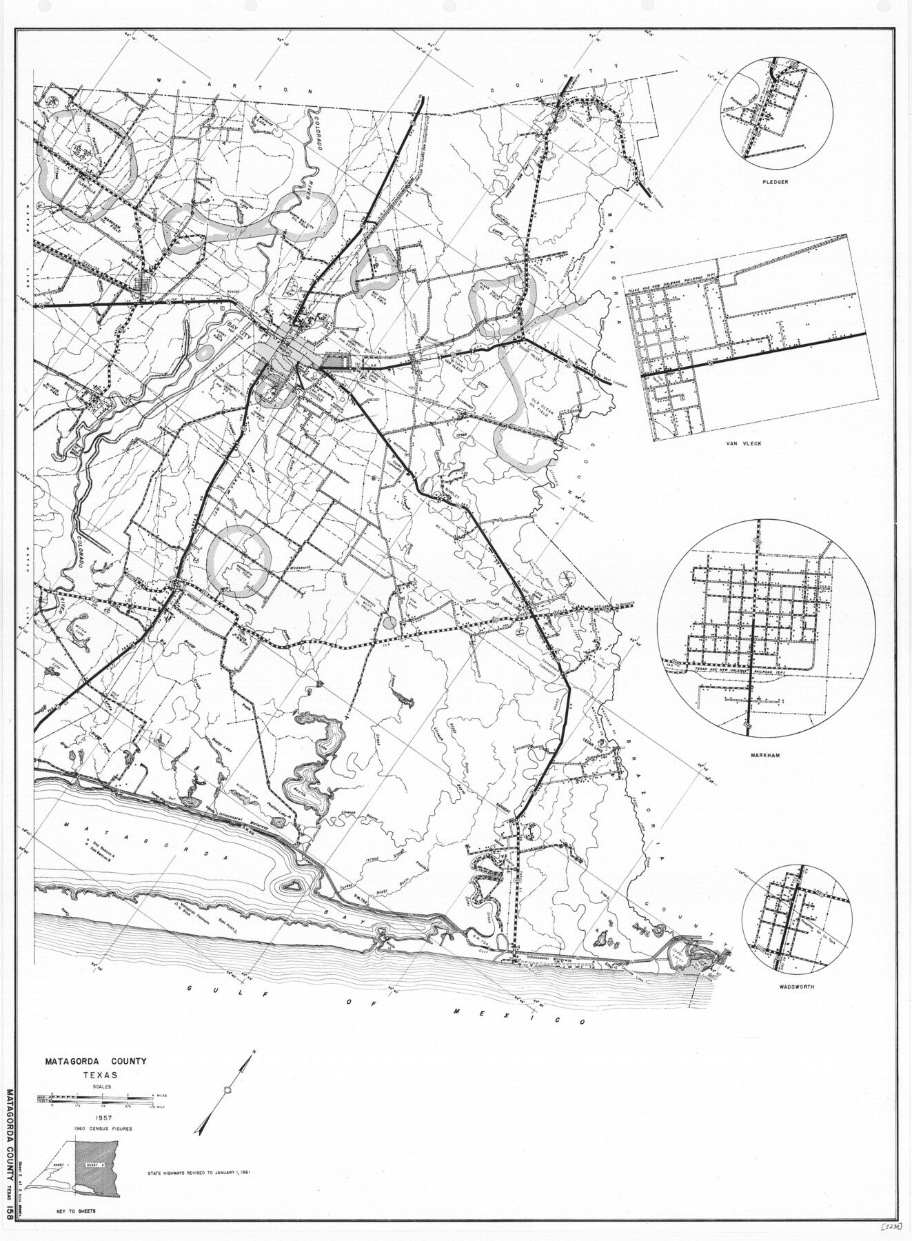
General Highway Map, Matagorda County, Texas
-
Map/Doc
79586
-
Collection
Texas State Library and Archives
-
Object Dates
1961 (Creation Date)
-
People and Organizations
Texas State Highway Department (Publisher)
-
Counties
Matagorda
-
Subjects
County
-
Height x Width
24.7 x 18.2 inches
62.7 x 46.2 cm
-
Comments
Prints available courtesy of the Texas State Library and Archives.
More info can be found here: TSLAC Map 05230
Part of: Texas State Library and Archives
General Highway Map, Waller County, Texas

Print $20.00
General Highway Map, Waller County, Texas
1961
Size 24.9 x 18.2 inches
Map/Doc 79700
Lampasas County Oil Field

Print $20.00
Lampasas County Oil Field
1920
Size 22.4 x 28.8 inches
Map/Doc 79326
General Highway Map, Limestone County, Texas

Print $20.00
General Highway Map, Limestone County, Texas
1961
Size 18.1 x 24.8 inches
Map/Doc 79572
General Highway Map, Mills County, Texas

Print $20.00
General Highway Map, Mills County, Texas
1961
Size 18.2 x 24.6 inches
Map/Doc 79599
General Highway Map, Refugio County, Texas

Print $20.00
General Highway Map, Refugio County, Texas
1940
Size 18.3 x 25.0 inches
Map/Doc 79228
General Highway Map, San Saba County, Texas

Print $20.00
General Highway Map, San Saba County, Texas
1940
Size 18.3 x 24.8 inches
Map/Doc 79238
General Highway Map, Jefferson County, Texas

Print $20.00
General Highway Map, Jefferson County, Texas
1940
Size 24.8 x 18.6 inches
Map/Doc 79144
General Highway Map, Kerr County, Texas

Print $20.00
General Highway Map, Kerr County, Texas
1940
Size 24.8 x 18.2 inches
Map/Doc 79157
General Highway Map, Shackelford County, Texas

Print $20.00
General Highway Map, Shackelford County, Texas
1961
Size 18.1 x 24.8 inches
Map/Doc 79651
General Highway Map, Floyd County, Texas

Print $20.00
General Highway Map, Floyd County, Texas
1961
Size 24.6 x 18.1 inches
Map/Doc 79467
General Highway Map, Coryell County, Texas

Print $20.00
General Highway Map, Coryell County, Texas
1961
Size 18.1 x 24.8 inches
Map/Doc 79422
General Highway Map, Armstrong County, Texas

Print $20.00
General Highway Map, Armstrong County, Texas
1961
Size 18.3 x 25.0 inches
Map/Doc 79354
You may also like
Gaines County Sketch File 21

Print $6.00
- Digital $50.00
Gaines County Sketch File 21
1990
Size 11.2 x 8.8 inches
Map/Doc 23341
Souvenir - Opening and Dedication of the General Oil Company's New West Texas Oil Field

Souvenir - Opening and Dedication of the General Oil Company's New West Texas Oil Field
1920
Map/Doc 97263
Aransas County Rolled Sketch 2

Print $40.00
- Digital $50.00
Aransas County Rolled Sketch 2
Size 42.9 x 48.2 inches
Map/Doc 73614
San Augustine County Rolled Sketch 3

Print $20.00
- Digital $50.00
San Augustine County Rolled Sketch 3
1969
Size 21.5 x 29.0 inches
Map/Doc 7555
Harris County Working Sketch 79

Print $20.00
- Digital $50.00
Harris County Working Sketch 79
1968
Size 22.4 x 22.9 inches
Map/Doc 65971
Kinney County Working Sketch 25

Print $20.00
- Digital $50.00
Kinney County Working Sketch 25
1952
Size 30.9 x 32.9 inches
Map/Doc 70207
Hunt County Working Sketch 4

Print $20.00
- Digital $50.00
Hunt County Working Sketch 4
1923
Size 21.3 x 30.5 inches
Map/Doc 66351
Chambers County Sketch File 5

Print $2.00
- Digital $50.00
Chambers County Sketch File 5
Size 7.2 x 6.3 inches
Map/Doc 17539
Gulf Intracoastal Waterway, Tex. - Aransas Bay to Corpus Christi Bay - Modified Route of Main Channel/Dredging

Print $20.00
- Digital $50.00
Gulf Intracoastal Waterway, Tex. - Aransas Bay to Corpus Christi Bay - Modified Route of Main Channel/Dredging
1958
Size 31.0 x 42.8 inches
Map/Doc 61895
Kinney County Working Sketch 31

Print $20.00
- Digital $50.00
Kinney County Working Sketch 31
1961
Size 30.9 x 47.3 inches
Map/Doc 70213
Galveston County Sketch File 59

Print $8.00
- Digital $50.00
Galveston County Sketch File 59
1977
Size 14.2 x 8.7 inches
Map/Doc 23607
[Block B9 and 3KA]
![90329, [Block B9 and 3KA], Twichell Survey Records](https://historictexasmaps.com/wmedia_w700/maps/90329-1.tif.jpg)
Print $20.00
- Digital $50.00
[Block B9 and 3KA]
Size 31.4 x 17.8 inches
Map/Doc 90329