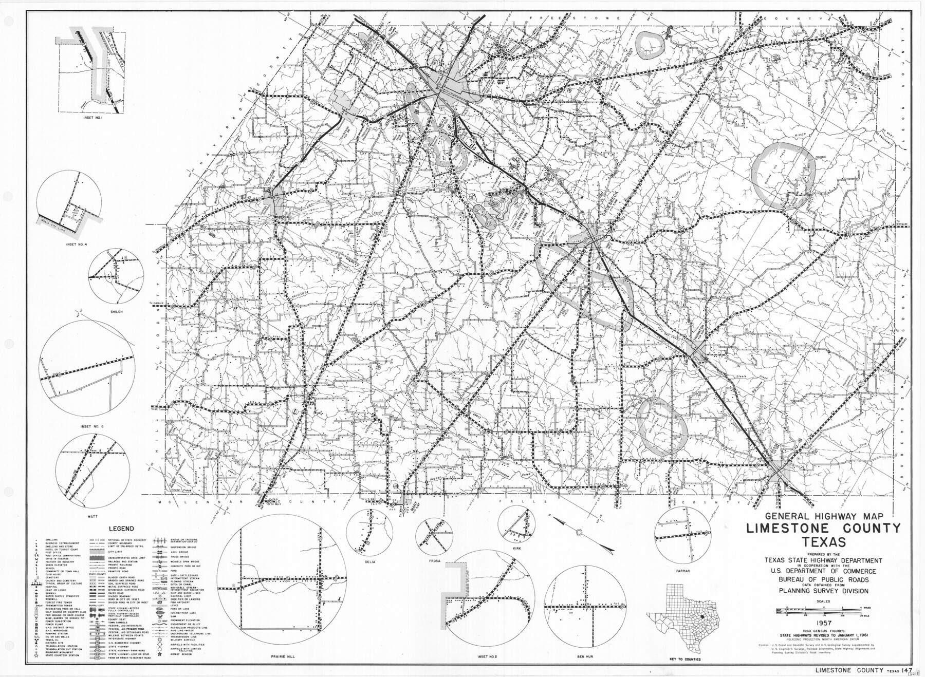
General Highway Map, Limestone County, Texas
-
Map/Doc
79572
-
Collection
Texas State Library and Archives
-
Object Dates
1961 (Creation Date)
-
People and Organizations
Texas State Highway Department (Publisher)
-
Counties
Limestone
-
Subjects
County
-
Height x Width
18.1 x 24.8 inches
46.0 x 63.0 cm
-
Comments
Prints available courtesy of the Texas State Library and Archives.
More info can be found here: TSLAC Map 05218
Part of: Texas State Library and Archives
General Highway Map, Hartley County, Texas

Print $20.00
General Highway Map, Hartley County, Texas
1961
Size 24.4 x 18.0 inches
Map/Doc 79511
General Highway Map, Johnson County, Texas

Print $20.00
General Highway Map, Johnson County, Texas
1961
Size 18.2 x 24.8 inches
Map/Doc 79545
General Highway Map, Liberty County, Texas

Print $20.00
General Highway Map, Liberty County, Texas
1961
Size 18.2 x 24.7 inches
Map/Doc 79570
General Highway Map, Bowie County, Texas

Print $20.00
General Highway Map, Bowie County, Texas
1940
Size 18.4 x 24.9 inches
Map/Doc 79023
Railroad and County Map of Texas

Print $20.00
Railroad and County Map of Texas
1901
Size 33.1 x 37.1 inches
Map/Doc 76213
General Highway Map. Detail of Cities and Towns in Dallas County, Texas [Dallas and vicinity]
![79068, General Highway Map. Detail of Cities and Towns in Dallas County, Texas [Dallas and vicinity], Texas State Library and Archives](https://historictexasmaps.com/wmedia_w700/maps/79068.tif.jpg)
Print $20.00
General Highway Map. Detail of Cities and Towns in Dallas County, Texas [Dallas and vicinity]
1936
Size 18.5 x 25.2 inches
Map/Doc 79068
General Highway Map, Coleman County, Texas

Print $20.00
General Highway Map, Coleman County, Texas
1961
Size 24.6 x 18.3 inches
Map/Doc 79412
General Highway Map, Cameron County, Texas

Print $20.00
General Highway Map, Cameron County, Texas
1940
Size 18.5 x 25.3 inches
Map/Doc 79039
Map of Mexico, Texas, Old and New California, and Yucatan

Print $20.00
Map of Mexico, Texas, Old and New California, and Yucatan
1847
Size 17.9 x 24.4 inches
Map/Doc 76191
General Highway Map, Dimmit County, Zavala County, Texas

Print $20.00
General Highway Map, Dimmit County, Zavala County, Texas
1961
Size 18.2 x 24.6 inches
Map/Doc 79444
General Highway Map, Houston County, Texas

Print $20.00
General Highway Map, Houston County, Texas
1961
Size 24.6 x 18.3 inches
Map/Doc 79524
Partial View of Austin, Texas

Print $20.00
Partial View of Austin, Texas
1895
Size 28.4 x 41.8 inches
Map/Doc 76205
You may also like
Chambers County Working Sketch 19

Print $20.00
- Digital $50.00
Chambers County Working Sketch 19
1965
Size 23.5 x 25.8 inches
Map/Doc 68002
Dimmit County, Texas

Print $20.00
- Digital $50.00
Dimmit County, Texas
1879
Size 22.6 x 28.6 inches
Map/Doc 5031
Seagraves Cemetery, Gaines County, Texas

Print $20.00
- Digital $50.00
Seagraves Cemetery, Gaines County, Texas
Size 23.2 x 19.2 inches
Map/Doc 92685
[Surveying Test and Answer Key]
![76001, [Surveying Test and Answer Key], General Map Collection](https://historictexasmaps.com/wmedia_w700/maps/76001.tif.jpg)
Print $20.00
- Digital $50.00
[Surveying Test and Answer Key]
Size 17.5 x 19.9 inches
Map/Doc 76001
Llano County Sketch File 15

Print $2.00
- Digital $50.00
Llano County Sketch File 15
Size 10.4 x 7.7 inches
Map/Doc 30391
Map of Chicago, Rock Island & Texas Railway through Montague and Wise Counties, Texas

Print $40.00
- Digital $50.00
Map of Chicago, Rock Island & Texas Railway through Montague and Wise Counties, Texas
1893
Size 20.2 x 124.5 inches
Map/Doc 64468
Kent County Working Sketch 14

Print $20.00
- Digital $50.00
Kent County Working Sketch 14
1965
Size 28.2 x 35.4 inches
Map/Doc 70021
Camp County Sketch File 1

Print $4.00
- Digital $50.00
Camp County Sketch File 1
Size 10.4 x 8.1 inches
Map/Doc 17333
A new and complete county map of all the rail roads in the United States & Canadas in operation & progress.

Print $20.00
A new and complete county map of all the rail roads in the United States & Canadas in operation & progress.
1857
Size 19.3 x 22.0 inches
Map/Doc 93606
Dawson County Rolled Sketch 11

Print $20.00
- Digital $50.00
Dawson County Rolled Sketch 11
1961
Size 21.5 x 26.1 inches
Map/Doc 5694
[Castro, Lamb, Hockley, Swisher, Hale, and Lubbock Counties]
![91026, [Castro, Lamb, Hockley, Swisher, Hale, and Lubbock Counties], Twichell Survey Records](https://historictexasmaps.com/wmedia_w700/maps/91026-1.tif.jpg)
Print $20.00
- Digital $50.00
[Castro, Lamb, Hockley, Swisher, Hale, and Lubbock Counties]
Size 28.7 x 37.6 inches
Map/Doc 91026
