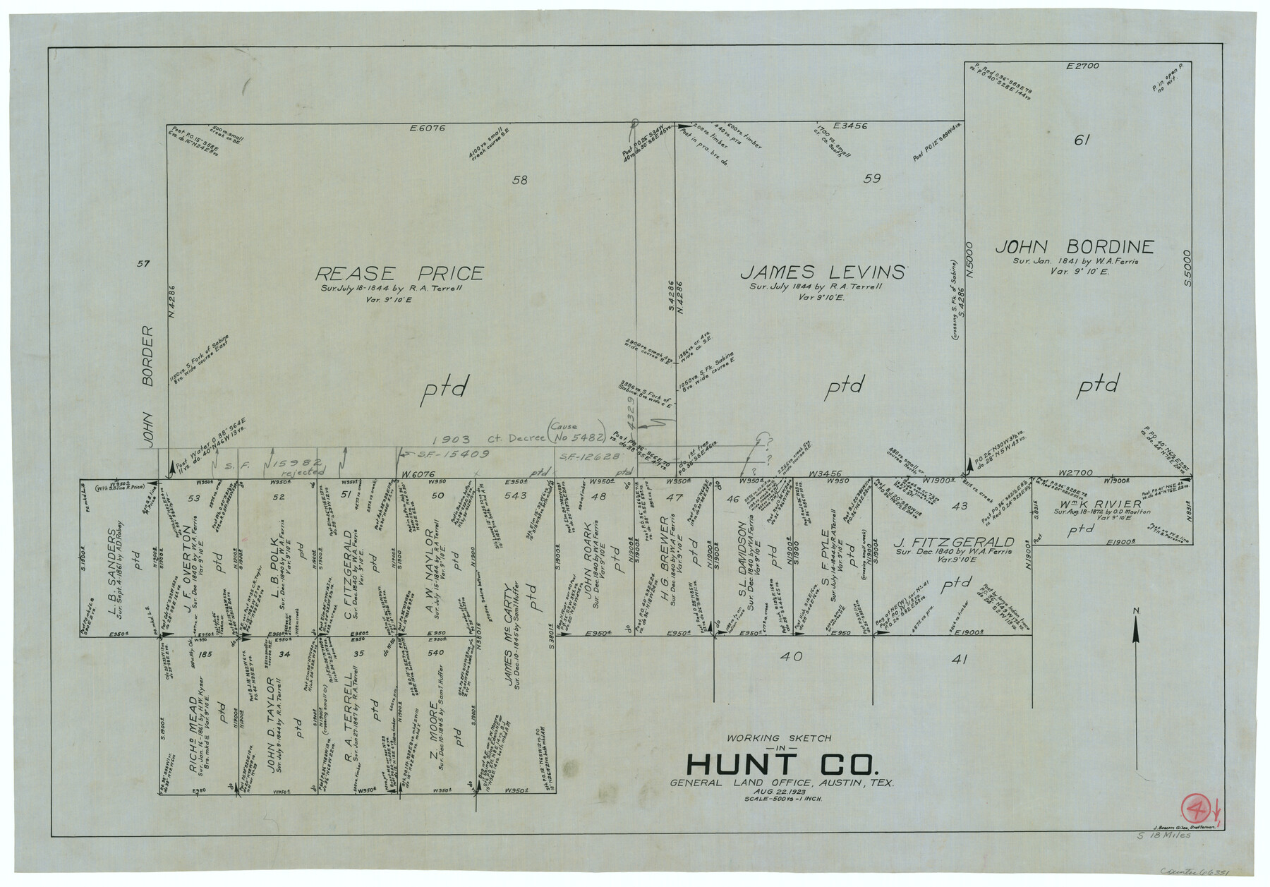
Hunt County Working Sketch 4
-
Map/Doc
66351
-
Collection
General Map Collection
-
Object Dates
8/22/1923 (Creation Date)
-
People and Organizations
J. Bascom Giles (Draftsman)
-
Counties
Hunt
-
Subjects
Surveying Working Sketch
-
Height x Width
21.3 x 30.5 inches
54.1 x 77.5 cm
-
Scale
1" = 500 varas
Part of: General Map Collection
Flight Mission No. CRC-3R, Frame 199, Chambers County

Print $20.00
- Digital $50.00
Flight Mission No. CRC-3R, Frame 199, Chambers County
1956
Size 18.5 x 22.3 inches
Map/Doc 84854
[Sketch for Mineral Application 16700 - Pecos River Bed]
![2808, [Sketch for Mineral Application 16700 - Pecos River Bed], General Map Collection](https://historictexasmaps.com/wmedia_w700/maps/2808.tif.jpg)
Print $20.00
- Digital $50.00
[Sketch for Mineral Application 16700 - Pecos River Bed]
1927
Size 19.9 x 30.9 inches
Map/Doc 2808
Clay County Sketch File 6

Print $4.00
- Digital $50.00
Clay County Sketch File 6
1854
Size 8.1 x 12.5 inches
Map/Doc 18395

Donley County Sketch File 28

Print $40.00
- Digital $50.00
Donley County Sketch File 28
Size 25.7 x 9.1 inches
Map/Doc 21266
Missouri Pacific Railway System

Print $20.00
- Digital $50.00
Missouri Pacific Railway System
1888
Size 20.0 x 20.0 inches
Map/Doc 89223
Dawson County Working Sketch 13

Print $20.00
- Digital $50.00
Dawson County Working Sketch 13
1952
Size 18.1 x 12.6 inches
Map/Doc 68557
Flight Mission No. BQR-22K, Frame 39, Brazoria County

Print $20.00
- Digital $50.00
Flight Mission No. BQR-22K, Frame 39, Brazoria County
1953
Size 18.8 x 22.4 inches
Map/Doc 84123
Dickens County Sketch File 30

Print $11.00
- Digital $50.00
Dickens County Sketch File 30
Size 8.3 x 8.2 inches
Map/Doc 21020
Jefferson Co.

Print $20.00
- Digital $50.00
Jefferson Co.
1918
Size 46.7 x 40.8 inches
Map/Doc 16860
Harbor of Brazos Santiago, Texas

Print $20.00
- Digital $50.00
Harbor of Brazos Santiago, Texas
1887
Size 27.1 x 18.1 inches
Map/Doc 72991
Hudspeth County Working Sketch 31

Print $40.00
- Digital $50.00
Hudspeth County Working Sketch 31
1972
Size 56.2 x 41.2 inches
Map/Doc 66314
You may also like
Stephens County Sketch File 14

Print $6.00
- Digital $50.00
Stephens County Sketch File 14
Size 8.2 x 5.9 inches
Map/Doc 37065
Polk County Sketch File 2a

Print $4.00
- Digital $50.00
Polk County Sketch File 2a
1863
Size 12.2 x 8.1 inches
Map/Doc 34120
Brazoria County Working Sketch 9

Print $20.00
- Digital $50.00
Brazoria County Working Sketch 9
1934
Size 36.6 x 35.9 inches
Map/Doc 67494
Garza County Rolled Sketch 6D

Print $20.00
- Digital $50.00
Garza County Rolled Sketch 6D
1913
Size 17.4 x 16.0 inches
Map/Doc 5998
Brewster County Sketch File 48

Print $4.00
- Digital $50.00
Brewster County Sketch File 48
1940
Size 11.4 x 9.2 inches
Map/Doc 16327
Liberty County Sketch File 6

Print $6.00
- Digital $50.00
Liberty County Sketch File 6
1856
Size 12.1 x 7.7 inches
Map/Doc 29893
Working Sketch in Potter & Moore Counties

Print $40.00
- Digital $50.00
Working Sketch in Potter & Moore Counties
1919
Size 54.1 x 43.5 inches
Map/Doc 89721
Copy of Map from General Land Office

Print $20.00
- Digital $50.00
Copy of Map from General Land Office
1880
Size 16.6 x 17.2 inches
Map/Doc 93361
Sketch of Surveys on Peach Point, J. Perry's Property

Print $20.00
- Digital $50.00
Sketch of Surveys on Peach Point, J. Perry's Property
1832
Size 14.0 x 20.6 inches
Map/Doc 219
[Southeast Yoakum County, Southwest Terry County and North Gaines County]
![91876, [Southeast Yoakum County, Southwest Terry County and North Gaines County], Twichell Survey Records](https://historictexasmaps.com/wmedia_w700/maps/91876-1.tif.jpg)
Print $20.00
- Digital $50.00
[Southeast Yoakum County, Southwest Terry County and North Gaines County]
Size 20.7 x 16.6 inches
Map/Doc 91876
Glasscock County Sketch File 3

Print $3.00
- Digital $50.00
Glasscock County Sketch File 3
1931
Size 11.1 x 14.8 inches
Map/Doc 11560
Brazoria County Working Sketch 33

Print $20.00
- Digital $50.00
Brazoria County Working Sketch 33
1980
Size 29.6 x 35.6 inches
Map/Doc 67518