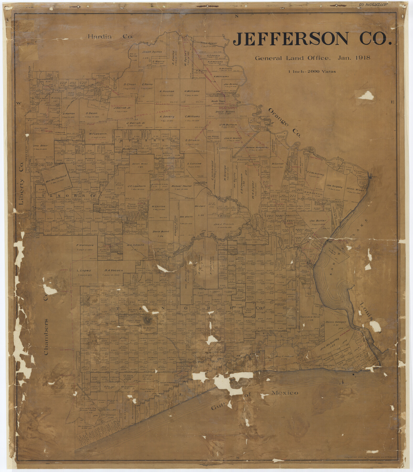
Jefferson Co.
-
Map/Doc
16860
-
Collection
General Map Collection
-
Object Dates
1918 (Creation Date)
-
People and Organizations
Texas General Land Office (Publisher)
H.M. Bramlette (Compiler)
H.M. Bramlette (Draftsman)
H.F. McDonald (Compiler)
H.F. McDonald (Draftsman)
-
Counties
Jefferson
-
Subjects
County
-
Height x Width
46.7 x 40.8 inches
118.6 x 103.6 cm
-
Comments
Conservation funded in 2002 with donation from Jefferson County Title Company.
-
Features
Mayhaw Bayou
Double Point Bayou
Hillenbrand Bayou
Fannet
Taylors Bayou
Delphine
El Vista
Port Arthur
Port Arthur
Hamshire
West Port Arthur
Alligator Bayou
Sabine Lake
Blue Buck Point
Round Lake
Bayou Din
Winnie
Stowell
Big Hill
Keith Lake
Sabine Pass
Salt Lake
Knight Lake
Fence Lake
Long Lake
Star Lake
Sea Breeze
Whites Ranch
Gulf of Mexico
Mud Bayou
Clarks Island
Voth
GB&KC
GC&SF
T&NO
Chita
Willow Marsh [Bayou]
Cotton Creek
Westbury
Pine Island Station
BSL&W
Elizabeth
Beaumont
Mansfield Ferry
Neches River
Pine Island Bayou
Spindletop
T&FTS
Guffey
G&I
China
Nome
Cheek
Hebert
Port Neches
Molasses Bayou
Boons Island
Nederland
Lucas
Viterbo
Part of: General Map Collection
Leon County Working Sketch 11

Print $20.00
- Digital $50.00
Leon County Working Sketch 11
1952
Size 21.1 x 35.0 inches
Map/Doc 70410
Haskell County Sketch File 3

Print $8.00
- Digital $50.00
Haskell County Sketch File 3
Size 9.8 x 8.8 inches
Map/Doc 26121
Maps of Gulf Intracoastal Waterway, Texas - Sabine River to the Rio Grande and connecting waterways including ship channels

Print $20.00
- Digital $50.00
Maps of Gulf Intracoastal Waterway, Texas - Sabine River to the Rio Grande and connecting waterways including ship channels
1966
Size 14.5 x 22.4 inches
Map/Doc 61918
Presidio County Rolled Sketch 56

Print $20.00
- Digital $50.00
Presidio County Rolled Sketch 56
1915
Size 21.8 x 17.1 inches
Map/Doc 7349
Ft. W. & R. G. Ry. Right of Way Map, Chapin to Bluffdale, Hood County, Texas

Print $40.00
- Digital $50.00
Ft. W. & R. G. Ry. Right of Way Map, Chapin to Bluffdale, Hood County, Texas
1918
Size 36.5 x 50.5 inches
Map/Doc 64645
Padre Island National Seashore, Texas - Dependent Resurvey

Print $4.00
- Digital $50.00
Padre Island National Seashore, Texas - Dependent Resurvey
2001
Size 18.5 x 24.2 inches
Map/Doc 60547
Reeves County Working Sketch 9

Print $20.00
- Digital $50.00
Reeves County Working Sketch 9
1948
Size 19.0 x 24.0 inches
Map/Doc 63452
Cameron County

Print $20.00
- Digital $50.00
Cameron County
1976
Size 32.2 x 39.0 inches
Map/Doc 73098
Nueces County Sketch File 11

Print $40.00
- Digital $50.00
Nueces County Sketch File 11
1859
Size 11.2 x 8.6 inches
Map/Doc 32518
Flight Mission No. DQN-5K, Frame 60, Calhoun County

Print $20.00
- Digital $50.00
Flight Mission No. DQN-5K, Frame 60, Calhoun County
1953
Size 15.5 x 15.4 inches
Map/Doc 84403
Menard County Working Sketch 23

Print $20.00
- Digital $50.00
Menard County Working Sketch 23
1950
Size 45.1 x 41.3 inches
Map/Doc 70970
Hutchinson County Sketch File 10

Print $40.00
- Digital $50.00
Hutchinson County Sketch File 10
Size 55.8 x 9.2 inches
Map/Doc 10500
You may also like
Southwest Part of Anton Chico Grant Guadalupe County, New Mexico

Print $20.00
- Digital $50.00
Southwest Part of Anton Chico Grant Guadalupe County, New Mexico
Size 23.8 x 28.6 inches
Map/Doc 92435
[H. & G.N. RR. Co. Block 4 and vicinity]
![92160, [H. & G.N. RR. Co. Block 4 and vicinity], Twichell Survey Records](https://historictexasmaps.com/wmedia_w700/maps/92160-1.tif.jpg)
Print $20.00
- Digital $50.00
[H. & G.N. RR. Co. Block 4 and vicinity]
Size 40.8 x 37.4 inches
Map/Doc 92160
Flight Mission No. DQO-7K, Frame 102, Galveston County

Print $20.00
- Digital $50.00
Flight Mission No. DQO-7K, Frame 102, Galveston County
1952
Size 18.6 x 22.5 inches
Map/Doc 85117
From Citizens of Nacogdoches County for the Creation of a New Judicial County (Unnamed), November 16, 1840

Print $20.00
From Citizens of Nacogdoches County for the Creation of a New Judicial County (Unnamed), November 16, 1840
2020
Size 14.6 x 21.7 inches
Map/Doc 96409
Flight Mission No. CRK-8P, Frame 114, Refugio County

Print $20.00
- Digital $50.00
Flight Mission No. CRK-8P, Frame 114, Refugio County
1956
Size 18.3 x 22.1 inches
Map/Doc 86969
Lamar County Working Sketch 3

Print $20.00
- Digital $50.00
Lamar County Working Sketch 3
1919
Size 26.2 x 24.5 inches
Map/Doc 70264
Flight Mission No. CLL-1N, Frame 35, Willacy County

Print $20.00
- Digital $50.00
Flight Mission No. CLL-1N, Frame 35, Willacy County
1954
Size 18.5 x 22.1 inches
Map/Doc 87016
[City of Lamesa and vicinity]
![92593, [City of Lamesa and vicinity], Twichell Survey Records](https://historictexasmaps.com/wmedia_w700/maps/92593-1.tif.jpg)
Print $20.00
- Digital $50.00
[City of Lamesa and vicinity]
1946
Size 33.9 x 10.5 inches
Map/Doc 92593

Flight Mission No. BRE-3P, Frame 78, Nueces County

Print $20.00
- Digital $50.00
Flight Mission No. BRE-3P, Frame 78, Nueces County
1956
Size 18.5 x 22.2 inches
Map/Doc 86819
G. C. & S. F. Ry. Alinement [sic] and Right of Way Map of Dallas Branch, Johnson County, Texas
![64650, G. C. & S. F. Ry. Alinement [sic] and Right of Way Map of Dallas Branch, Johnson County, Texas, General Map Collection](https://historictexasmaps.com/wmedia_w700/maps/64650.tif.jpg)
Print $40.00
- Digital $50.00
G. C. & S. F. Ry. Alinement [sic] and Right of Way Map of Dallas Branch, Johnson County, Texas
1925
Size 38.0 x 125.2 inches
Map/Doc 64650
Glasscock County Sketch File 25

Print $20.00
- Digital $50.00
Glasscock County Sketch File 25
1951
Size 28.8 x 20.6 inches
Map/Doc 11566