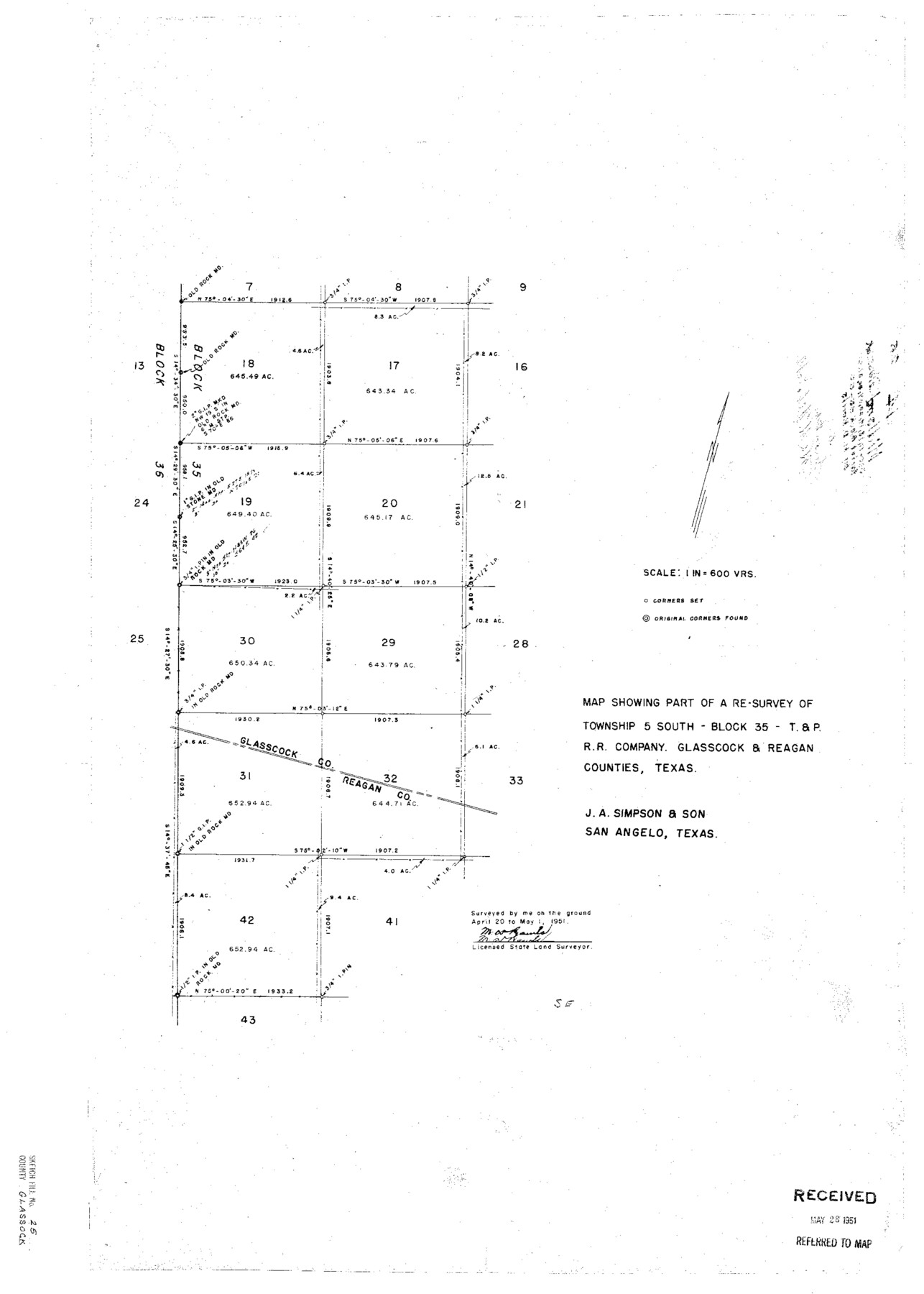
Glasscock County Sketch File 25
Map Showing Part of a Re-Survey of Township 5 South - Block 35 - T.&P. R.R. Company Glasscock & Reagan Counties, Texas
-
Map/Doc
11566
-
Collection
General Map Collection
-
Object Dates
5/1951 (Creation Date)
5/28/1951 (File Date)
4/20/1951 - 5/1/1951 (Survey Date)
-
People and Organizations
M.D. Rawls (Surveyor/Engineer)
-
Counties
Glasscock Reagan
-
Subjects
Surveying Sketch File
-
Height x Width
28.8 x 20.6 inches
73.2 x 52.3 cm
-
Medium
paper, photocopy
-
Scale
1" = 600 varas
Part of: General Map Collection
Wheeler County Working Sketch 19

Print $20.00
- Digital $50.00
Wheeler County Working Sketch 19
1986
Size 33.5 x 31.8 inches
Map/Doc 72508
[Sketch for Mineral Applications 7410, 7411, 7412, 7413, 7712 - Kleberg County]
![65624, [Sketch for Mineral Applications 7410, 7411, 7412, 7413, 7712 - Kleberg County], General Map Collection](https://historictexasmaps.com/wmedia_w700/maps/65624-1.tif.jpg)
Print $40.00
- Digital $50.00
[Sketch for Mineral Applications 7410, 7411, 7412, 7413, 7712 - Kleberg County]
1977
Size 91.9 x 44.5 inches
Map/Doc 65624
San Augustine County Sketch File 3

Print $10.00
San Augustine County Sketch File 3
1858
Size 11.8 x 8.1 inches
Map/Doc 35635
Pecos County Rolled Sketch 77

Print $20.00
- Digital $50.00
Pecos County Rolled Sketch 77
1930
Size 38.4 x 23.4 inches
Map/Doc 7238
Flight Mission No. CGI-4N, Frame 175, Cameron County

Print $20.00
- Digital $50.00
Flight Mission No. CGI-4N, Frame 175, Cameron County
1955
Size 18.6 x 22.4 inches
Map/Doc 84678
Carson County Sketch File 6

Print $32.00
- Digital $50.00
Carson County Sketch File 6
1928
Size 9.1 x 9.6 inches
Map/Doc 17358
Nacogdoches County Sketch File 9

Print $20.00
- Digital $50.00
Nacogdoches County Sketch File 9
Size 8.3 x 26.9 inches
Map/Doc 32252
Culberson County Working Sketch 70

Print $40.00
- Digital $50.00
Culberson County Working Sketch 70
1975
Size 50.3 x 32.2 inches
Map/Doc 68524
Flight Mission No. DCL-6C, Frame 68, Kenedy County

Print $20.00
- Digital $50.00
Flight Mission No. DCL-6C, Frame 68, Kenedy County
1943
Size 18.6 x 22.4 inches
Map/Doc 85910
Jasper County Sketch File 34

Print $4.00
- Digital $50.00
Jasper County Sketch File 34
1873
Size 12.4 x 8.1 inches
Map/Doc 27868
Winkler County Rolled Sketch 7

Print $20.00
- Digital $50.00
Winkler County Rolled Sketch 7
1929
Size 27.6 x 32.5 inches
Map/Doc 8273
Morris County Rolled Sketch 2A

Print $20.00
- Digital $50.00
Morris County Rolled Sketch 2A
Size 24.3 x 19.1 inches
Map/Doc 10239
You may also like
Leon County Texas

Print $20.00
- Digital $50.00
Leon County Texas
1896
Size 25.4 x 22.1 inches
Map/Doc 3806
Flight Mission No. DAH-17M, Frame 64, Orange County

Print $20.00
- Digital $50.00
Flight Mission No. DAH-17M, Frame 64, Orange County
1953
Size 18.4 x 22.3 inches
Map/Doc 86898
Gaines County Working Sketch 17

Print $20.00
- Digital $50.00
Gaines County Working Sketch 17
1964
Size 47.6 x 34.5 inches
Map/Doc 69317

Sutton County Sketch File 6a

Print $6.00
- Digital $50.00
Sutton County Sketch File 6a
1898
Size 7.5 x 6.4 inches
Map/Doc 37362
Flight Mission No. DAG-23K, Frame 21, Matagorda County

Print $20.00
- Digital $50.00
Flight Mission No. DAG-23K, Frame 21, Matagorda County
1953
Size 18.4 x 22.3 inches
Map/Doc 86483
[Sketch for Mineral Application 26546 - Sabine River between Hawkins Creek and east boundary line of BBB&C RR Co. Surveys, R. S. Rathke]
![65666, [Sketch for Mineral Application 26546 - Sabine River between Hawkins Creek and east boundary line of BBB&C RR Co. Surveys, R. S. Rathke], General Map Collection](https://historictexasmaps.com/wmedia_w700/maps/65666.tif.jpg)
Print $40.00
- Digital $50.00
[Sketch for Mineral Application 26546 - Sabine River between Hawkins Creek and east boundary line of BBB&C RR Co. Surveys, R. S. Rathke]
1931
Size 74.9 x 26.3 inches
Map/Doc 65666
Texas Intracoastal Waterway - Matagorda Bay, Cedar Lakes to Oyster Lake

Print $20.00
- Digital $50.00
Texas Intracoastal Waterway - Matagorda Bay, Cedar Lakes to Oyster Lake
1956
Size 27.3 x 38.9 inches
Map/Doc 73367
Stephens County Rolled Sketch 5

Print $20.00
- Digital $50.00
Stephens County Rolled Sketch 5
Size 23.2 x 37.2 inches
Map/Doc 7842
Blanco County Working Sketch 3

Print $20.00
- Digital $50.00
Blanco County Working Sketch 3
Size 14.4 x 16.1 inches
Map/Doc 78189
From Citizens to Redefine the Boundary Between Gonzales and Victoria Counties, April 14, 18

Print $20.00
From Citizens to Redefine the Boundary Between Gonzales and Victoria Counties, April 14, 18
2020
Size 24.9 x 21.7 inches
Map/Doc 96378
Current Miscellaneous File 6

Print $4.00
- Digital $50.00
Current Miscellaneous File 6
Size 11.3 x 8.8 inches
Map/Doc 73731