San Augustine County Sketch File 3
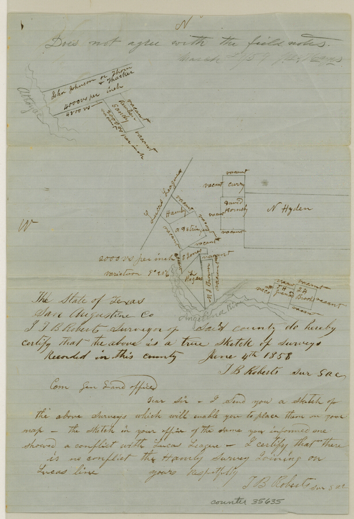
[Two sketches around the Jacob Garrett, John Lucas, and Nathaniel Hyden leagues in the southwest part of the county on the Angelina River]
-
Map/Doc
35635
-
Collection
General Map Collection
-
Object Dates
6/4/1858 (Creation Date)
6/16/1858 (File Date)
3/29/1859 (Creation Date)
9/24/1859 (File Date)
-
People and Organizations
T.B. Roberts (Surveyor/Engineer)
-
Counties
San Augustine
-
Subjects
Surveying Sketch File
-
Height x Width
11.8 x 8.1 inches
30.0 x 20.6 cm
-
Medium
paper, manuscript
-
Features
Attoyac River
Angelina River
Part of: General Map Collection
Chambers County Rolled Sketch 26

Print $20.00
- Digital $50.00
Chambers County Rolled Sketch 26
1947
Size 12.7 x 19.9 inches
Map/Doc 5428
Fayette County Boundary File 5

Print $59.00
- Digital $50.00
Fayette County Boundary File 5
Size 14.4 x 9.0 inches
Map/Doc 53371
Karnes County Rolled Sketch 1

Print $20.00
- Digital $50.00
Karnes County Rolled Sketch 1
1943
Size 27.5 x 25.7 inches
Map/Doc 6452
Galveston County NRC Article 33.136 Sketch 16

Print $28.00
- Digital $50.00
Galveston County NRC Article 33.136 Sketch 16
2002
Size 25.3 x 36.2 inches
Map/Doc 78314
Real County Working Sketch 44

Print $20.00
- Digital $50.00
Real County Working Sketch 44
1953
Size 28.3 x 24.3 inches
Map/Doc 71936
Runnels County Sketch File 36

Print $20.00
Runnels County Sketch File 36
1889
Size 20.9 x 19.6 inches
Map/Doc 12267
Nolan County Sketch File 18

Print $8.00
- Digital $50.00
Nolan County Sketch File 18
Size 14.3 x 8.9 inches
Map/Doc 32489
Red River County Working Sketch 69

Print $20.00
- Digital $50.00
Red River County Working Sketch 69
1975
Size 23.7 x 19.1 inches
Map/Doc 72052
Atascosa County Sketch File 17

Print $2.00
- Digital $50.00
Atascosa County Sketch File 17
Size 7.9 x 6.6 inches
Map/Doc 13783
Winkler County Working Sketch 7

Print $20.00
- Digital $50.00
Winkler County Working Sketch 7
1958
Size 45.4 x 30.2 inches
Map/Doc 72601
Knox County Working Sketch 5

Print $20.00
- Digital $50.00
Knox County Working Sketch 5
1919
Size 27.1 x 23.2 inches
Map/Doc 70247
Limestone County Sketch File 11

Print $4.00
- Digital $50.00
Limestone County Sketch File 11
1881
Size 7.9 x 9.5 inches
Map/Doc 30177
You may also like
Wharton County Working Sketch 13

Print $20.00
- Digital $50.00
Wharton County Working Sketch 13
1968
Size 38.5 x 36.3 inches
Map/Doc 72477
Pecos County Sketch File 44

Print $8.00
- Digital $50.00
Pecos County Sketch File 44
Size 13.0 x 10.4 inches
Map/Doc 33743
Hidalgo County Working Sketch 2

Print $20.00
- Digital $50.00
Hidalgo County Working Sketch 2
1906
Size 22.0 x 28.0 inches
Map/Doc 66179
Nueces County Rolled Sketch 110

Print $20.00
- Digital $50.00
Nueces County Rolled Sketch 110
1990
Size 24.1 x 37.5 inches
Map/Doc 7117
Map of C. C. Slaughter Cattle Co.'s Ranch, Cochran-Hockley Counties, Texas

Print $20.00
- Digital $50.00
Map of C. C. Slaughter Cattle Co.'s Ranch, Cochran-Hockley Counties, Texas
Size 27.4 x 20.3 inches
Map/Doc 90439
Midland County Working Sketch 33

Print $20.00
- Digital $50.00
Midland County Working Sketch 33
1982
Size 38.2 x 36.2 inches
Map/Doc 71014
Flight Mission No. DQN-7K, Frame 89, Calhoun County

Print $20.00
- Digital $50.00
Flight Mission No. DQN-7K, Frame 89, Calhoun County
1953
Size 18.4 x 22.2 inches
Map/Doc 84480
Hartley County Sketch File 16

Print $4.00
- Digital $50.00
Hartley County Sketch File 16
Size 11.1 x 7.1 inches
Map/Doc 26113
Bee County Working Sketch 5

Print $20.00
- Digital $50.00
Bee County Working Sketch 5
1930
Size 21.1 x 14.5 inches
Map/Doc 67255
Nueces County NRC Article 33.136 Location Key Sheet

Print $20.00
- Digital $50.00
Nueces County NRC Article 33.136 Location Key Sheet
1975
Size 27.5 x 23.0 inches
Map/Doc 88589
Milam County Sketch File 4

Print $4.00
- Digital $50.00
Milam County Sketch File 4
Size 7.6 x 8.2 inches
Map/Doc 31630
[Surveys in Austin's Colony along the east bank of the Navidad River]
![211, [Surveys in Austin's Colony along the east bank of the Navidad River], General Map Collection](https://historictexasmaps.com/wmedia_w700/maps/211.tif.jpg)
Print $20.00
- Digital $50.00
[Surveys in Austin's Colony along the east bank of the Navidad River]
1827
Size 20.2 x 16.1 inches
Map/Doc 211