Hartley County Sketch File 16
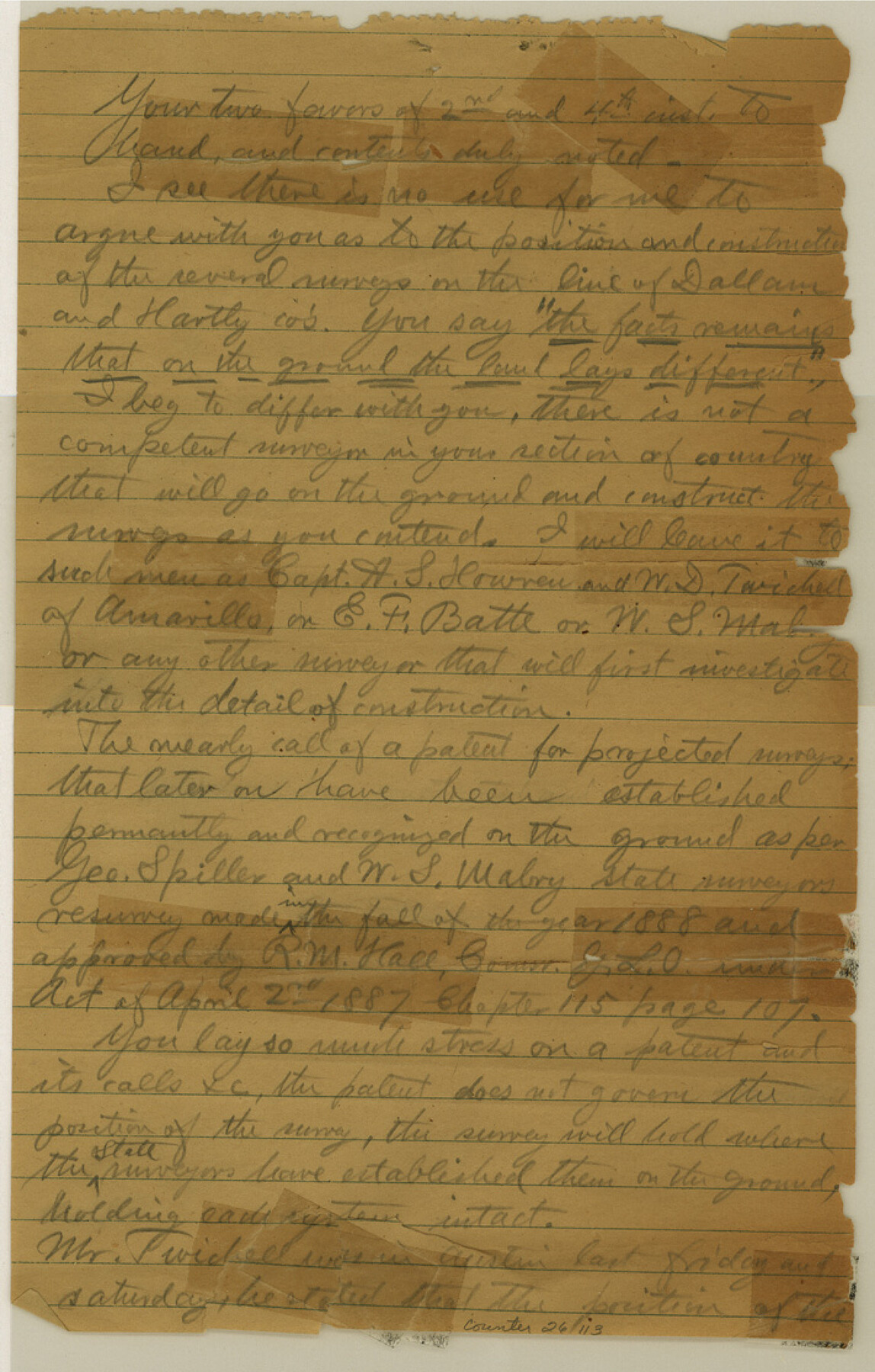
[Letter concerning surveys on line between Dallam and Hartley Counties]
-
Map/Doc
26113
-
Collection
General Map Collection
-
Object Dates
1888 (Survey Date)
-
People and Organizations
George Spiller (Surveyor/Engineer)
W.S. Mabry (Surveyor/Engineer)
-
Counties
Hartley Dallam
-
Subjects
Surveying Sketch File
-
Height x Width
11.1 x 7.1 inches
28.2 x 18.0 cm
-
Medium
paper, manuscript
Part of: General Map Collection
Eastland County Rolled Sketch 25

Print $20.00
- Digital $50.00
Eastland County Rolled Sketch 25
1990
Size 36.9 x 47.7 inches
Map/Doc 8831
Edwards County Working Sketch 10

Print $20.00
- Digital $50.00
Edwards County Working Sketch 10
1920
Size 21.9 x 18.3 inches
Map/Doc 68886
Flight Mission No. DCL-7C, Frame 121, Kenedy County

Print $20.00
- Digital $50.00
Flight Mission No. DCL-7C, Frame 121, Kenedy County
1943
Size 18.5 x 22.3 inches
Map/Doc 86086
Tom Green County Working Sketch 15

Print $20.00
- Digital $50.00
Tom Green County Working Sketch 15
1988
Size 32.9 x 37.5 inches
Map/Doc 69384

Flight Mission No. CUG-2P, Frame 69, Kleberg County

Print $20.00
- Digital $50.00
Flight Mission No. CUG-2P, Frame 69, Kleberg County
1956
Size 18.4 x 22.2 inches
Map/Doc 86206
Gaines County Working Sketch 25

Print $20.00
- Digital $50.00
Gaines County Working Sketch 25
1983
Size 37.5 x 38.4 inches
Map/Doc 69325
Schleicher County Working Sketch 16

Print $20.00
- Digital $50.00
Schleicher County Working Sketch 16
1942
Size 24.5 x 26.4 inches
Map/Doc 63818
Brewster County Rolled Sketch 18B

Print $20.00
- Digital $50.00
Brewster County Rolled Sketch 18B
1906
Size 16.2 x 18.1 inches
Map/Doc 5197

Matagorda County Sketch File 16

Print $4.00
- Digital $50.00
Matagorda County Sketch File 16
Size 8.4 x 10.3 inches
Map/Doc 30780
Harris County Sketch File AA3

Print $8.00
- Digital $50.00
Harris County Sketch File AA3
Size 8.2 x 8.5 inches
Map/Doc 25326
You may also like
Map of Bastrop County, Texas

Print $20.00
- Digital $50.00
Map of Bastrop County, Texas
1879
Size 24.6 x 24.1 inches
Map/Doc 4507
Brazoria County Rolled Sketch 32

Print $20.00
- Digital $50.00
Brazoria County Rolled Sketch 32
Size 29.1 x 22.6 inches
Map/Doc 5170

Crockett County Working Sketch 92

Print $20.00
- Digital $50.00
Crockett County Working Sketch 92
1978
Size 39.5 x 41.2 inches
Map/Doc 68425
[Terry County Highways]
![92905, [Terry County Highways], Twichell Survey Records](https://historictexasmaps.com/wmedia_w700/maps/92905-1.tif.jpg)
Print $20.00
- Digital $50.00
[Terry County Highways]
Size 17.0 x 16.8 inches
Map/Doc 92905
Crockett County Rolled Sketch 29

Print $20.00
- Digital $50.00
Crockett County Rolled Sketch 29
1927
Size 21.9 x 36.6 inches
Map/Doc 5588
[Township 2 North, Blocks 32 and 33]
![91212, [Township 2 North, Blocks 32 and 33], Twichell Survey Records](https://historictexasmaps.com/wmedia_w700/maps/91212-1.tif.jpg)
Print $3.00
- Digital $50.00
[Township 2 North, Blocks 32 and 33]
Size 11.8 x 10.8 inches
Map/Doc 91212
Pecos County Working Sketch 53

Print $20.00
- Digital $50.00
Pecos County Working Sketch 53
1948
Size 37.6 x 25.8 inches
Map/Doc 71525
Donley County Sketch File 5

Print $14.00
- Digital $50.00
Donley County Sketch File 5
Size 12.9 x 8.5 inches
Map/Doc 21223
Matagorda County NRC Article 33.136 Sketch 16

Digital $50.00
Matagorda County NRC Article 33.136 Sketch 16
2023
Map/Doc 97256
Pecos County Working Sketch 141

Print $20.00
- Digital $50.00
Pecos County Working Sketch 141
1941
Size 31.8 x 42.5 inches
Map/Doc 9733
Harrison County Sketch File 2

Print $4.00
- Digital $50.00
Harrison County Sketch File 2
1853
Size 8.1 x 9.9 inches
Map/Doc 26034