Current Miscellaneous File 6
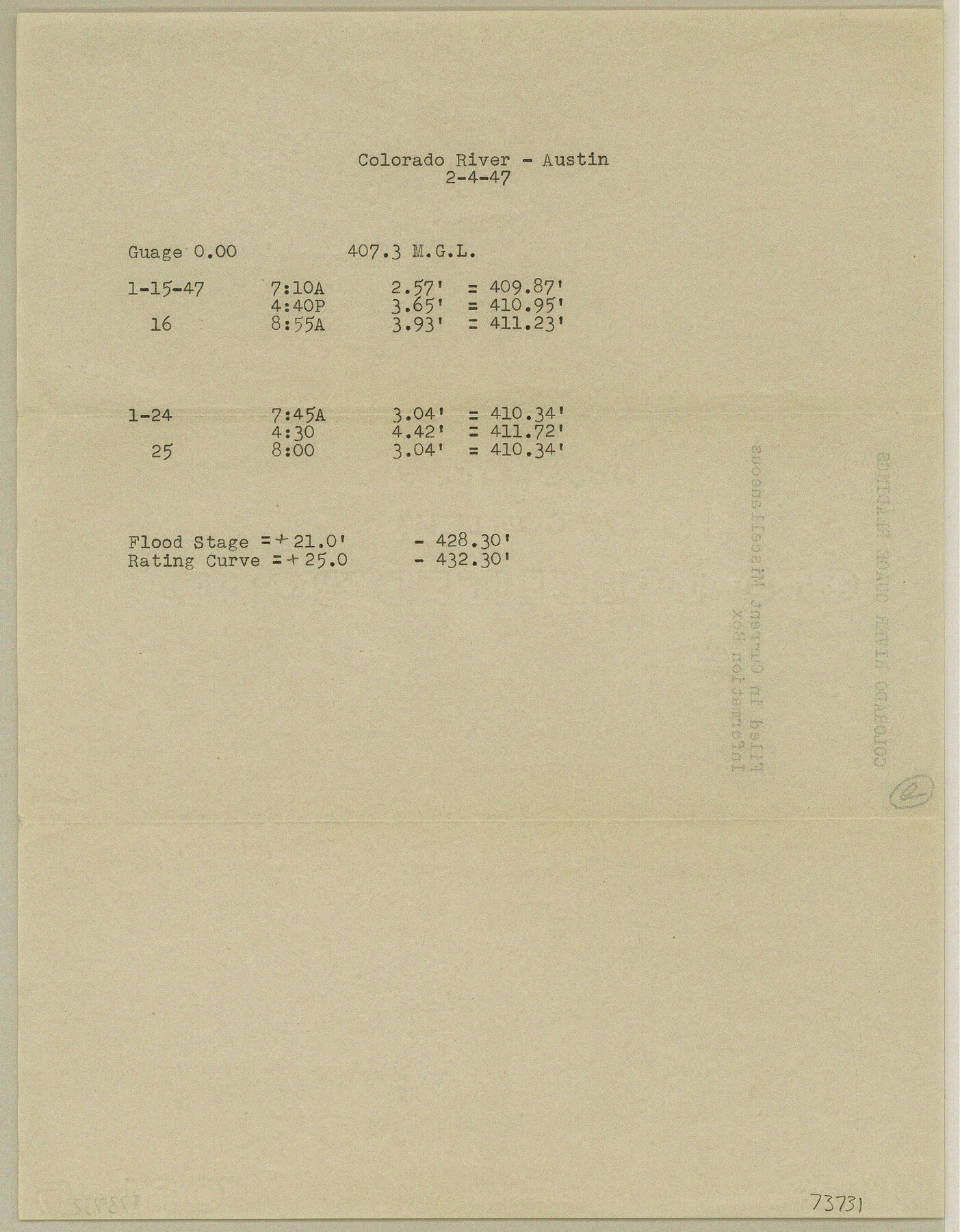
Colorado River gauge readings
-
Map/Doc
73731
-
Collection
General Map Collection
-
Subjects
River Surveys
-
Height x Width
11.3 x 8.8 inches
28.7 x 22.4 cm
Part of: General Map Collection
Schleicher County Sketch File 27

Print $20.00
- Digital $50.00
Schleicher County Sketch File 27
Size 23.0 x 19.2 inches
Map/Doc 12305
McLennan County Sketch File 20

Print $2.00
- Digital $50.00
McLennan County Sketch File 20
Size 8.0 x 9.1 inches
Map/Doc 31293
Grayson County Sketch File 3a

Print $20.00
- Digital $50.00
Grayson County Sketch File 3a
1855
Size 19.6 x 25.5 inches
Map/Doc 11580
Terrell County Working Sketch 6

Print $20.00
- Digital $50.00
Terrell County Working Sketch 6
1914
Size 15.7 x 21.9 inches
Map/Doc 62155
Flight Mission No. DIX-8P, Frame 94, Aransas County

Print $20.00
- Digital $50.00
Flight Mission No. DIX-8P, Frame 94, Aransas County
1956
Size 18.5 x 22.3 inches
Map/Doc 83919
Duval County Sketch File 33

Print $55.00
- Digital $50.00
Duval County Sketch File 33
1932
Size 14.4 x 8.8 inches
Map/Doc 21342
Montgomery County Rolled Sketch 43

Print $20.00
- Digital $50.00
Montgomery County Rolled Sketch 43
1971
Size 32.1 x 34.3 inches
Map/Doc 6822
Sherman County Rolled Sketch 4

Print $20.00
- Digital $50.00
Sherman County Rolled Sketch 4
Size 23.1 x 31.7 inches
Map/Doc 7786
Gaines County Working Sketch 13

Print $20.00
- Digital $50.00
Gaines County Working Sketch 13
1954
Size 36.8 x 39.4 inches
Map/Doc 69313
Real County Working Sketch 57

Print $20.00
- Digital $50.00
Real County Working Sketch 57
1962
Size 19.6 x 25.8 inches
Map/Doc 71949
Uvalde County Working Sketch 56

Print $20.00
- Digital $50.00
Uvalde County Working Sketch 56
1985
Size 44.8 x 40.6 inches
Map/Doc 72126
Flight Mission No. DQN-1K, Frame 83, Calhoun County

Print $20.00
- Digital $50.00
Flight Mission No. DQN-1K, Frame 83, Calhoun County
1953
Size 18.4 x 22.2 inches
Map/Doc 84168
You may also like
Hardin County Sketch File 55

Print $40.00
- Digital $50.00
Hardin County Sketch File 55
1924
Size 14.2 x 13.3 inches
Map/Doc 25220
[Surveys along the Red River and Capitol Lands]
![90738, [Surveys along the Red River and Capitol Lands], Twichell Survey Records](https://historictexasmaps.com/wmedia_w700/maps/90738-1.tif.jpg)
Print $20.00
- Digital $50.00
[Surveys along the Red River and Capitol Lands]
Size 24.8 x 39.7 inches
Map/Doc 90738
Nueces County Working Sketch 1

Print $20.00
- Digital $50.00
Nueces County Working Sketch 1
1937
Size 27.9 x 28.5 inches
Map/Doc 71303
Map of Floyd County

Print $20.00
- Digital $50.00
Map of Floyd County
1888
Size 25.4 x 19.6 inches
Map/Doc 3547
Cochran County

Print $20.00
- Digital $50.00
Cochran County
1946
Size 30.8 x 23.1 inches
Map/Doc 77239
Dallas County Sketch File 7

Print $4.00
- Digital $50.00
Dallas County Sketch File 7
1858
Size 10.4 x 8.5 inches
Map/Doc 20408
Callahan County Sketch File 3

Print $40.00
- Digital $50.00
Callahan County Sketch File 3
1860
Size 17.4 x 13.8 inches
Map/Doc 35857

Victoria County Aerial Photograph Index Sheet 5

Print $20.00
- Digital $50.00
Victoria County Aerial Photograph Index Sheet 5
1953
Size 19.8 x 23.6 inches
Map/Doc 83749
Bandera County Rolled Sketch 9

Print $20.00
- Digital $50.00
Bandera County Rolled Sketch 9
Size 21.2 x 24.2 inches
Map/Doc 5120
San Jacinto County

Print $40.00
- Digital $50.00
San Jacinto County
1942
Size 49.7 x 44.1 inches
Map/Doc 95633
Haskell County Boundary File 5

Print $80.00
- Digital $50.00
Haskell County Boundary File 5
Size 16.5 x 11.9 inches
Map/Doc 54578