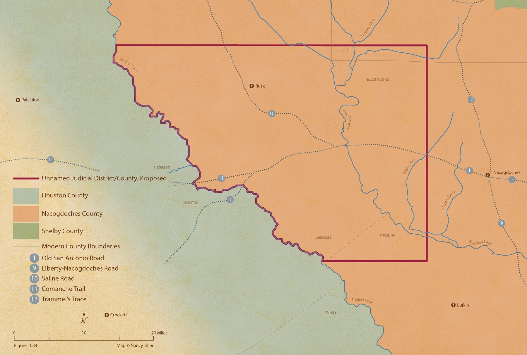
From Citizens of Nacogdoches County for the Creation of a New Judicial County (Unnamed), November 16, 1840
Figure No. 1034 from 'A Boundary Atlas of Texas, 1821-1845' by Jim Tiller
-
Map/Doc
96409
-
Collection
Nancy and Jim Tiller Digital Collection
-
Object Dates
2020/1/1 (Creation Date)
-
People and Organizations
Jim Tiller (Author)
Nancy Tiller (Cartographer)
Gang Gong (GIS Professional)
-
Subjects
Atlas Republic of Texas Texas Boundaries
-
Height x Width
14.6 x 21.7 inches
37.1 x 55.1 cm
-
Medium
digital image
-
Comments
To purchase a digital PDF copy of "A Boundary Atlas of Texas, 1821-1845" see 96437.
Part of: Nancy and Jim Tiller Digital Collection
The Mexican Municipality of Colorado. Created, January 11, 1836

Print $20.00
The Mexican Municipality of Colorado. Created, January 11, 1836
2020
Size 15.7 x 21.6 inches
Map/Doc 96019
The Judicial District/County of Menard. Created, January 22, 1841

Print $20.00
The Judicial District/County of Menard. Created, January 22, 1841
2020
Size 22.4 x 21.7 inches
Map/Doc 96335
The Chief Justice County of Brazoria. April 24, 1837

Print $20.00
The Chief Justice County of Brazoria. April 24, 1837
2020
Size 14.8 x 21.7 inches
Map/Doc 96042
The Republic County of Jasper. December 29, 1845

Print $20.00
The Republic County of Jasper. December 29, 1845
2020
Size 19.5 x 21.7 inches
Map/Doc 96196
The Republic County of Austin. February 5, 1840

Print $20.00
The Republic County of Austin. February 5, 1840
2020
Size 14.7 x 21.7 inches
Map/Doc 96084
The Republic County of San Patricio. December 31, 1838

Print $20.00
The Republic County of San Patricio. December 31, 1838
2020
Size 22.2 x 21.7 inches
Map/Doc 96275
The Chief Justice County of Jasper. Lands in Conflict with Sabine County

Print $20.00
The Chief Justice County of Jasper. Lands in Conflict with Sabine County
2020
Size 18.3 x 21.7 inches
Map/Doc 96053
de Leon Empresario Colony. Absorbed by DeWitt Colony. April 15, 1825

Print $20.00
de Leon Empresario Colony. Absorbed by DeWitt Colony. April 15, 1825
2020
Size 18.5 x 21.7 inches
Map/Doc 95989
Republic-Era Colonies. 1841-1844

Print $20.00
Republic-Era Colonies. 1841-1844
2020
Size 22.7 x 21.7 inches
Map/Doc 96372

The Republic County of Gonzales. December 29, 1845

Print $20.00
The Republic County of Gonzales. December 29, 1845
2020
Size 14.7 x 21.7 inches
Map/Doc 96160
The Republic County of Jackson. 1840

Print $20.00
The Republic County of Jackson. 1840
2020
Size 15.6 x 21.8 inches
Map/Doc 96186
You may also like
Flight Mission No. DAG-26K, Frame 57, Matagorda County

Print $20.00
- Digital $50.00
Flight Mission No. DAG-26K, Frame 57, Matagorda County
1953
Size 18.5 x 22.6 inches
Map/Doc 86577
Flight Mission No. DQO-8K, Frame 49, Galveston County

Print $20.00
- Digital $50.00
Flight Mission No. DQO-8K, Frame 49, Galveston County
1952
Size 18.7 x 22.3 inches
Map/Doc 85156
Packery Channel

Print $3.00
- Digital $50.00
Packery Channel
1974
Size 10.2 x 10.3 inches
Map/Doc 3000
Nacogdoches County

Print $40.00
- Digital $50.00
Nacogdoches County
1950
Size 51.0 x 42.4 inches
Map/Doc 66950
Presidio County Sketch File P2

Print $6.00
- Digital $50.00
Presidio County Sketch File P2
Size 14.3 x 8.9 inches
Map/Doc 34558
Partie du Mexique

Print $20.00
- Digital $50.00
Partie du Mexique
1827
Size 20.4 x 27.8 inches
Map/Doc 94072
Plan of the town of Austin

Print $20.00
- Digital $50.00
Plan of the town of Austin
Size 18.4 x 13.0 inches
Map/Doc 94117
General Highway Map, Callahan County, Texas

Print $20.00
General Highway Map, Callahan County, Texas
1940
Size 25.3 x 18.4 inches
Map/Doc 79037
Webb County Working Sketch 38

Print $20.00
- Digital $50.00
Webb County Working Sketch 38
1941
Size 20.0 x 17.8 inches
Map/Doc 72403
Harris County Sketch File 20

Print $6.00
- Digital $50.00
Harris County Sketch File 20
1862
Size 8.6 x 7.9 inches
Map/Doc 25368
[Sketch of expeditions, trails in Jones, Taylor, Shackelford, Callahan, Buchanan/Stephens and Eastland Counties]
![65405, [Sketch of expeditions, trails in Jones, Taylor, Shackelford, Callahan, Buchanan/Stephens and Eastland Counties], General Map Collection](https://historictexasmaps.com/wmedia_w700/maps/65405.tif.jpg)
Print $4.00
- Digital $50.00
[Sketch of expeditions, trails in Jones, Taylor, Shackelford, Callahan, Buchanan/Stephens and Eastland Counties]
1873
Size 10.8 x 18.3 inches
Map/Doc 65405
[Surveys along the Leon River and Plum Creek]
![69730, [Surveys along the Leon River and Plum Creek], General Map Collection](https://historictexasmaps.com/wmedia_w700/maps/69730.tif.jpg)
Print $2.00
- Digital $50.00
[Surveys along the Leon River and Plum Creek]
1846
Size 9.0 x 14.0 inches
Map/Doc 69730